陆地表面降温:生态系统健康和水资源可用性驱动景观能力以减缓气候变化
IF 7
2区 环境科学与生态学
Q1 ENVIRONMENTAL SCIENCES
引用次数: 0
摘要
地表温度(LST)与景观状态、设置和功能有着深刻的联系,且联系十分复杂。虽然湿地和(半)自然栖息地在缓解极端气候方面的作用已被普遍理解,但解释复杂景观中热模式的机制仍不清楚。我们解决了这一知识差距,研究了地表温度动态与不同砂岩景观特征之间的联系,重点研究了水景和森林健康在缓解极端温度方面的作用。在我们的研究中,我们使用了捷克共和国北部砂岩保护区的一个模型示例,由于树皮甲虫的侵扰以及随之而来的森林死亡和野火,该保护区在过去十年中发生了重大变化。地表温度数据来自基于云的谷歌地球引擎平台上的MODIS和Landsat 8传感器。机器学习回归模型使我们能够评估复杂的多变量关系并提高LST的空间分辨率。结果表明,水分有效性和生态系统健康对地表温度均有显著影响,植被指数、土地覆盖和高程是影响地表温度的主要因素。星载地表温度与地面实测温度的相关性取决于冠层覆盖度。研究表明,在复杂的景观中,高时空分辨率的地表温度数据是解析局地格局和环境驱动因素的必要条件。卫星数据可以作为了解机制和制定适应性管理措施的可靠手段,使景观更能抵御与气候变化有关的威胁。本文章由计算机程序翻译,如有差异,请以英文原文为准。
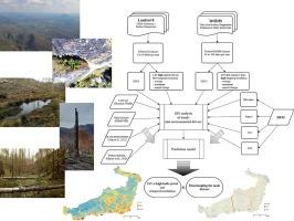
Cooling the land surface: Ecosystem health and water availability drive the landscape capacity to mitigate climate change
Land surface temperature (LST) is profoundly interlinked with the landscape state, settings and functioning, with the connections being very complex. Although the role of wetlands and (semi)natural habitats, in mitigating climate extremes is generally understood, the mechanisms explaining the thermal patterns in complex landscapes remain unclear. We address this knowledge gap, investigating a link between the dynamics of LST and characteristics of a diverse sandstone landscape, focusing on the role of water features and forest health in alleviating temperature extremes. For our study, we used a model example of a sandstone protected area in the north of the Czech Republic that underwent significant changes during the last decade due to a bark beetle infestation and a consequent forest die-off and wildfire. LST data were obtained from MODIS and Landsat 8 sensors in a cloud-based Google Earth Engine platform. Machine learning regression model enabled us to assess complex multivariable relationships and increase the LST spatial resolution. The results suggest the significant effect of both water availability and ecosystem health on LST, with vegetation indices, land cover and elevation being the main factors. The correlation of the satellite-based LST and in situ measured temperature depended on the canopy cover. The study indicates that in complex landscapes, LST data of high spatial and temporal resolution is necessary to disentangle local patterns and environmental drivers. Satellite data can serve as a reliable means to understand the mechanisms and prepare adaptive management measures to make the landscape more resistant to climate change related threats.
求助全文
通过发布文献求助,成功后即可免费获取论文全文。
去求助
来源期刊

Ecological Indicators
环境科学-环境科学
CiteScore
11.80
自引率
8.70%
发文量
1163
审稿时长
78 days
期刊介绍:
The ultimate aim of Ecological Indicators is to integrate the monitoring and assessment of ecological and environmental indicators with management practices. The journal provides a forum for the discussion of the applied scientific development and review of traditional indicator approaches as well as for theoretical, modelling and quantitative applications such as index development. Research into the following areas will be published.
• All aspects of ecological and environmental indicators and indices.
• New indicators, and new approaches and methods for indicator development, testing and use.
• Development and modelling of indices, e.g. application of indicator suites across multiple scales and resources.
• Analysis and research of resource, system- and scale-specific indicators.
• Methods for integration of social and other valuation metrics for the production of scientifically rigorous and politically-relevant assessments using indicator-based monitoring and assessment programs.
• How research indicators can be transformed into direct application for management purposes.
• Broader assessment objectives and methods, e.g. biodiversity, biological integrity, and sustainability, through the use of indicators.
• Resource-specific indicators such as landscape, agroecosystems, forests, wetlands, etc.
 求助内容:
求助内容: 应助结果提醒方式:


