基于多源卫星水下地形数据的干旱未测盆地湖泊水库长期蓄水量监测

IF 8 1区 环境科学与生态学 Q1 ENVIRONMENTAL SCIENCES
Jing Wang , Yongnian Gao
{"title":"基于多源卫星水下地形数据的干旱未测盆地湖泊水库长期蓄水量监测","authors":"Jing Wang ,&nbsp;Yongnian Gao","doi":"10.1016/j.scitotenv.2025.178662","DOIUrl":null,"url":null,"abstract":"<div><div>Accurate underwater topography and water storage data of lakes and reservoirs are crucial for evaluating their functionality and sustainable water resources management. However, due to the scarcity of in-situ data, acquiring such information for remote lakes and reservoirs remains challenging. In this study, we derived multiple underwater elevation points of 14 lakes and reservoirs in the Tarim River Basin of China using ICESat-2 data, combined with the cubic B-spline fitting method. Subsequently, we utilized multi-temporal Sentinel-2 remote sensing data to map the underwater topography of these 14 lakes and reservoirs by inverting underwater elevation. Monthly time series of water area, levels, and storage were subsequently derived, offering a long-term perspective on the water dynamics of the 14 lakes and reservoirs from 1990 to 2021. The results indicate that, compared with the existing contour data of A.lake (Bosten Lake), the underwater elevation points exhibits high accuracy, with an R<sup>2</sup> of 0.90, a mean-absolute-error (MAE) of 0.72 m, and a root-mean-square error (RMSE) of 1.01 m. Additionally, the underwater topographic map of A.lake (Bosten Lake) demonstrates a high degree of fit, with an R<sup>2</sup> of 0.86, a MAE of 1.27 m, and an RMSE of 1.69 m. The findings of this study suggest that ICESat-2 data, combined with optical remote sensing imagery, are effective for mapping lakes and reservoirs in remote inland regions. Additionally, the storage dynamics of these 14 lakes and reservoirs between 1990 and 2021 reveal a notable interannual increase in water storage within the study area during the 2010–2012 period, whereas changes in the upper limit of reservoir storage were comparatively less significant. This study offers an effective approach for investigating the underwater topography and water storage of remote lakes and reservoirs with limited in-situ data, providing valuable reference information for characterizing these water bodies and managing water resources.</div></div>","PeriodicalId":422,"journal":{"name":"Science of the Total Environment","volume":"966 ","pages":"Article 178662"},"PeriodicalIF":8.0000,"publicationDate":"2025-02-04","publicationTypes":"Journal Article","fieldsOfStudy":null,"isOpenAccess":false,"openAccessPdf":"","citationCount":"0","resultStr":"{\"title\":\"Monitoring long-term water storage of lakes and reservoirs in arid ungauged basin based on underwater topography derived from multi-source satellite data\",\"authors\":\"Jing Wang ,&nbsp;Yongnian Gao\",\"doi\":\"10.1016/j.scitotenv.2025.178662\",\"DOIUrl\":null,\"url\":null,\"abstract\":\"<div><div>Accurate underwater topography and water storage data of lakes and reservoirs are crucial for evaluating their functionality and sustainable water resources management. However, due to the scarcity of in-situ data, acquiring such information for remote lakes and reservoirs remains challenging. In this study, we derived multiple underwater elevation points of 14 lakes and reservoirs in the Tarim River Basin of China using ICESat-2 data, combined with the cubic B-spline fitting method. Subsequently, we utilized multi-temporal Sentinel-2 remote sensing data to map the underwater topography of these 14 lakes and reservoirs by inverting underwater elevation. Monthly time series of water area, levels, and storage were subsequently derived, offering a long-term perspective on the water dynamics of the 14 lakes and reservoirs from 1990 to 2021. The results indicate that, compared with the existing contour data of A.lake (Bosten Lake), the underwater elevation points exhibits high accuracy, with an R<sup>2</sup> of 0.90, a mean-absolute-error (MAE) of 0.72 m, and a root-mean-square error (RMSE) of 1.01 m. Additionally, the underwater topographic map of A.lake (Bosten Lake) demonstrates a high degree of fit, with an R<sup>2</sup> of 0.86, a MAE of 1.27 m, and an RMSE of 1.69 m. The findings of this study suggest that ICESat-2 data, combined with optical remote sensing imagery, are effective for mapping lakes and reservoirs in remote inland regions. Additionally, the storage dynamics of these 14 lakes and reservoirs between 1990 and 2021 reveal a notable interannual increase in water storage within the study area during the 2010–2012 period, whereas changes in the upper limit of reservoir storage were comparatively less significant. This study offers an effective approach for investigating the underwater topography and water storage of remote lakes and reservoirs with limited in-situ data, providing valuable reference information for characterizing these water bodies and managing water resources.</div></div>\",\"PeriodicalId\":422,\"journal\":{\"name\":\"Science of the Total Environment\",\"volume\":\"966 \",\"pages\":\"Article 178662\"},\"PeriodicalIF\":8.0000,\"publicationDate\":\"2025-02-04\",\"publicationTypes\":\"Journal Article\",\"fieldsOfStudy\":null,\"isOpenAccess\":false,\"openAccessPdf\":\"\",\"citationCount\":\"0\",\"resultStr\":null,\"platform\":\"Semanticscholar\",\"paperid\":null,\"PeriodicalName\":\"Science of the Total Environment\",\"FirstCategoryId\":\"93\",\"ListUrlMain\":\"https://www.sciencedirect.com/science/article/pii/S0048969725002967\",\"RegionNum\":1,\"RegionCategory\":\"环境科学与生态学\",\"ArticlePicture\":[],\"TitleCN\":null,\"AbstractTextCN\":null,\"PMCID\":null,\"EPubDate\":\"\",\"PubModel\":\"\",\"JCR\":\"Q1\",\"JCRName\":\"ENVIRONMENTAL SCIENCES\",\"Score\":null,\"Total\":0}","platform":"Semanticscholar","paperid":null,"PeriodicalName":"Science of the Total Environment","FirstCategoryId":"93","ListUrlMain":"https://www.sciencedirect.com/science/article/pii/S0048969725002967","RegionNum":1,"RegionCategory":"环境科学与生态学","ArticlePicture":[],"TitleCN":null,"AbstractTextCN":null,"PMCID":null,"EPubDate":"","PubModel":"","JCR":"Q1","JCRName":"ENVIRONMENTAL SCIENCES","Score":null,"Total":0}
引用次数: 0

摘要

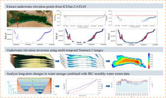
准确的湖泊和水库水下地形和蓄水数据对于评估其功能和可持续水资源管理至关重要。然而,由于原位数据稀缺,获取偏远湖泊和水库的此类信息仍具有挑战性。在本研究中,我们利用 ICESat-2 数据,结合三次 B-样条拟合方法,得出了中国塔里木河流域 14 个湖泊和水库的多个水下高程点。随后,我们利用多时相 Sentinel-2 遥感数据,通过反演水下高程,绘制了这 14 个湖泊和水库的水下地形图。随后得出了水域面积、水位和蓄水量的月度时间序列,从而提供了从 1990 年到 2021 年这 14 个湖泊和水库水体动态的长期视角。结果表明,与 A.湖(博斯腾湖)现有的等高线数据相比,水下高程点具有很高的精度,R2 为 0.90,平均绝对误差(MAE)为 0.72 米,均方根误差(RMSE)为 1.01 米。本研究的结果表明,ICESat-2 数据与光学遥感图像相结合,可有效绘制偏远内陆地区的湖泊和水库地图。此外,这 14 个湖泊和水库在 1990 年至 2021 年期间的蓄水动态显示,在 2010-2012 年期间,研究区域内的蓄水量在年际间显著增加,而水库蓄水上限的变化则相对较小。这项研究为利用有限的原位数据调查偏远湖泊和水库的水下地形和蓄水量提供了一种有效的方法,为描述这些水体的特征和管理水资源提供了宝贵的参考信息。
本文章由计算机程序翻译,如有差异,请以英文原文为准。

Monitoring long-term water storage of lakes and reservoirs in arid ungauged basin based on underwater topography derived from multi-source satellite data

Monitoring long-term water storage of lakes and reservoirs in arid ungauged basin based on underwater topography derived from multi-source satellite data
Accurate underwater topography and water storage data of lakes and reservoirs are crucial for evaluating their functionality and sustainable water resources management. However, due to the scarcity of in-situ data, acquiring such information for remote lakes and reservoirs remains challenging. In this study, we derived multiple underwater elevation points of 14 lakes and reservoirs in the Tarim River Basin of China using ICESat-2 data, combined with the cubic B-spline fitting method. Subsequently, we utilized multi-temporal Sentinel-2 remote sensing data to map the underwater topography of these 14 lakes and reservoirs by inverting underwater elevation. Monthly time series of water area, levels, and storage were subsequently derived, offering a long-term perspective on the water dynamics of the 14 lakes and reservoirs from 1990 to 2021. The results indicate that, compared with the existing contour data of A.lake (Bosten Lake), the underwater elevation points exhibits high accuracy, with an R2 of 0.90, a mean-absolute-error (MAE) of 0.72 m, and a root-mean-square error (RMSE) of 1.01 m. Additionally, the underwater topographic map of A.lake (Bosten Lake) demonstrates a high degree of fit, with an R2 of 0.86, a MAE of 1.27 m, and an RMSE of 1.69 m. The findings of this study suggest that ICESat-2 data, combined with optical remote sensing imagery, are effective for mapping lakes and reservoirs in remote inland regions. Additionally, the storage dynamics of these 14 lakes and reservoirs between 1990 and 2021 reveal a notable interannual increase in water storage within the study area during the 2010–2012 period, whereas changes in the upper limit of reservoir storage were comparatively less significant. This study offers an effective approach for investigating the underwater topography and water storage of remote lakes and reservoirs with limited in-situ data, providing valuable reference information for characterizing these water bodies and managing water resources.
求助全文
通过发布文献求助,成功后即可免费获取论文全文。 去求助
来源期刊
Science of the Total Environment
Science of the Total Environment 环境科学-环境科学
CiteScore
17.60
自引率
10.20%
发文量
8726
审稿时长
2.4 months
期刊介绍: The Science of the Total Environment is an international journal dedicated to scientific research on the environment and its interaction with humanity. It covers a wide range of disciplines and seeks to publish innovative, hypothesis-driven, and impactful research that explores the entire environment, including the atmosphere, lithosphere, hydrosphere, biosphere, and anthroposphere. The journal's updated Aims & Scope emphasizes the importance of interdisciplinary environmental research with broad impact. Priority is given to studies that advance fundamental understanding and explore the interconnectedness of multiple environmental spheres. Field studies are preferred, while laboratory experiments must demonstrate significant methodological advancements or mechanistic insights with direct relevance to the environment.
×
引用
GB/T 7714-2015
复制
MLA
复制
APA
复制
导出至
BibTeX EndNote RefMan NoteFirst NoteExpress
×
提示
您的信息不完整,为了账户安全,请先补充。
现在去补充
×
提示
您因"违规操作"
具体请查看互助需知
我知道了
×
提示
确定
请完成安全验证×
copy
已复制链接
快去分享给好友吧!
我知道了
右上角分享
点击右上角分享
0
联系我们:info@booksci.cn Book学术提供免费学术资源搜索服务,方便国内外学者检索中英文文献。致力于提供最便捷和优质的服务体验。 Copyright © 2023 布克学术 All rights reserved.
京ICP备2023020795号-1
ghs 京公网安备 11010802042870号
Book学术文献互助
Book学术文献互助群
群 号:604180095
Book学术官方微信