利用航空成像光谱和多光谱卫星图像绘制阿拉斯加卡切马克湾冰川沉积物羽流。

IF 5 2区 地球科学 Q1 WATER RESOURCES
L. Hartl , C. Schmitt , M. Stuefer , J. Jenckes , B. Page , C. Crawford , G. Schmidt , R. Yang , R. Hock
{"title":"利用航空成像光谱和多光谱卫星图像绘制阿拉斯加卡切马克湾冰川沉积物羽流。","authors":"L. Hartl ,&nbsp;C. Schmitt ,&nbsp;M. Stuefer ,&nbsp;J. Jenckes ,&nbsp;B. Page ,&nbsp;C. Crawford ,&nbsp;G. Schmidt ,&nbsp;R. Yang ,&nbsp;R. Hock","doi":"10.1016/j.ejrh.2024.102121","DOIUrl":null,"url":null,"abstract":"<div><div>Study Region</div><div>Kachemak Bay is a fjord-type estuary in the northern Gulf of Alaska. Water quality and habitat characteristics are strongly influenced by freshwater and sediment input from multiple glacierized catchments.</div><div>Study Focus</div><div>We present a new method combining imaging spectroscopy from an airborne survey with Landsat and Sentinel-2 imagery to map water surface turbidity originating from glacial runoff based on spectral abundance. We compare the spectral characteristics of turbid glacial water to clear water and generate a high resolution reference map of glacial turbidity in Kachemak Bay. This informs the subsequent analysis of a homogenized, Rayleigh corrected time series of Landsat and Sentinel-2 images and seasonal patterns of turbidity.</div><div>New Hydrological Insights for the Region</div><div>Our results provide the most comprehensive data set on water surface turbidity in Kachemak Bay to date and improve understanding of spatial and seasonal variability of glacial turbidity in a data sparse region. July and August have the largest plumes with median sizes around 150 km<span><math><msup><mrow></mrow><mrow><mn>2</mn></mrow></msup></math></span>, or around a quarter of Kachemak Bay. Plume sizes typically decrease with decreasing glacier runoff in September and October. We show that imaging spectroscopy aids assessments of turbid water in glacial marine catchments across scales. Leveraging high resolution spectral information allows for water color analyses that are customized to local conditions and catchment characteristics as well as scalable to wider regions.</div></div>","PeriodicalId":48620,"journal":{"name":"Journal of Hydrology-Regional Studies","volume":"57 ","pages":"Article 102121"},"PeriodicalIF":5.0000,"publicationDate":"2025-02-01","publicationTypes":"Journal Article","fieldsOfStudy":null,"isOpenAccess":false,"openAccessPdf":"https://www.ncbi.nlm.nih.gov/pmc/articles/PMC11754946/pdf/","citationCount":"0","resultStr":"{\"title\":\"Leveraging airborne imaging spectroscopy and multispectral satellite imagery to map glacial sediment plumes in Kachemak Bay, Alaska\",\"authors\":\"L. Hartl ,&nbsp;C. Schmitt ,&nbsp;M. Stuefer ,&nbsp;J. Jenckes ,&nbsp;B. Page ,&nbsp;C. Crawford ,&nbsp;G. Schmidt ,&nbsp;R. Yang ,&nbsp;R. Hock\",\"doi\":\"10.1016/j.ejrh.2024.102121\",\"DOIUrl\":null,\"url\":null,\"abstract\":\"<div><div>Study Region</div><div>Kachemak Bay is a fjord-type estuary in the northern Gulf of Alaska. Water quality and habitat characteristics are strongly influenced by freshwater and sediment input from multiple glacierized catchments.</div><div>Study Focus</div><div>We present a new method combining imaging spectroscopy from an airborne survey with Landsat and Sentinel-2 imagery to map water surface turbidity originating from glacial runoff based on spectral abundance. We compare the spectral characteristics of turbid glacial water to clear water and generate a high resolution reference map of glacial turbidity in Kachemak Bay. This informs the subsequent analysis of a homogenized, Rayleigh corrected time series of Landsat and Sentinel-2 images and seasonal patterns of turbidity.</div><div>New Hydrological Insights for the Region</div><div>Our results provide the most comprehensive data set on water surface turbidity in Kachemak Bay to date and improve understanding of spatial and seasonal variability of glacial turbidity in a data sparse region. July and August have the largest plumes with median sizes around 150 km<span><math><msup><mrow></mrow><mrow><mn>2</mn></mrow></msup></math></span>, or around a quarter of Kachemak Bay. Plume sizes typically decrease with decreasing glacier runoff in September and October. We show that imaging spectroscopy aids assessments of turbid water in glacial marine catchments across scales. Leveraging high resolution spectral information allows for water color analyses that are customized to local conditions and catchment characteristics as well as scalable to wider regions.</div></div>\",\"PeriodicalId\":48620,\"journal\":{\"name\":\"Journal of Hydrology-Regional Studies\",\"volume\":\"57 \",\"pages\":\"Article 102121\"},\"PeriodicalIF\":5.0000,\"publicationDate\":\"2025-02-01\",\"publicationTypes\":\"Journal Article\",\"fieldsOfStudy\":null,\"isOpenAccess\":false,\"openAccessPdf\":\"https://www.ncbi.nlm.nih.gov/pmc/articles/PMC11754946/pdf/\",\"citationCount\":\"0\",\"resultStr\":null,\"platform\":\"Semanticscholar\",\"paperid\":null,\"PeriodicalName\":\"Journal of Hydrology-Regional Studies\",\"FirstCategoryId\":\"89\",\"ListUrlMain\":\"https://www.sciencedirect.com/science/article/pii/S2214581824004701\",\"RegionNum\":2,\"RegionCategory\":\"地球科学\",\"ArticlePicture\":[],\"TitleCN\":null,\"AbstractTextCN\":null,\"PMCID\":null,\"EPubDate\":\"\",\"PubModel\":\"\",\"JCR\":\"Q1\",\"JCRName\":\"WATER RESOURCES\",\"Score\":null,\"Total\":0}","platform":"Semanticscholar","paperid":null,"PeriodicalName":"Journal of Hydrology-Regional Studies","FirstCategoryId":"89","ListUrlMain":"https://www.sciencedirect.com/science/article/pii/S2214581824004701","RegionNum":2,"RegionCategory":"地球科学","ArticlePicture":[],"TitleCN":null,"AbstractTextCN":null,"PMCID":null,"EPubDate":"","PubModel":"","JCR":"Q1","JCRName":"WATER RESOURCES","Score":null,"Total":0}
引用次数: 0

摘要

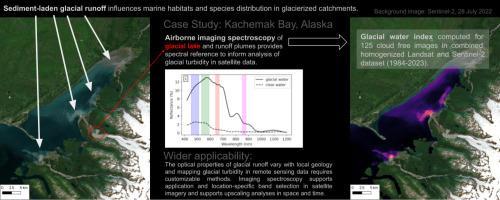
卡切马克湾是阿拉斯加湾北部的一个峡湾型河口。水质和生境特征受到多个冰川化集水区输入的淡水和沉积物的强烈影响。我们提出了一种基于光谱丰度,将航空调查成像光谱与Landsat和Sentinel-2图像相结合,绘制冰川径流产生的水面浑浊度的新方法。我们比较了浑浊冰川水和清澈冰川水的光谱特征,生成了Kachemak湾冰川浑浊度的高分辨率参考图。这为随后的均匀化、瑞利校正的Landsat和Sentinel-2图像时间序列以及浊度的季节性模式分析提供了依据。我们的研究结果提供了迄今为止关于Kachemak湾水面浑浊度的最全面的数据集,并提高了对数据稀疏地区冰川浑浊度的空间和季节变化的理解。7月和8月是最大的羽流,平均大小约为150平方公里,约占卡切马克湾的四分之一。在9月和10月,羽流大小通常随着冰川径流的减少而减少。我们表明,成像光谱辅助评估浑浊水在冰川海洋集水区跨越尺度。利用高分辨率的光谱信息,可以根据当地条件和流域特征进行定制的水色分析,并可扩展到更广泛的地区。
本文章由计算机程序翻译,如有差异,请以英文原文为准。

Leveraging airborne imaging spectroscopy and multispectral satellite imagery to map glacial sediment plumes in Kachemak Bay, Alaska

Leveraging airborne imaging spectroscopy and multispectral satellite imagery to map glacial sediment plumes in Kachemak Bay, Alaska
Study Region
Kachemak Bay is a fjord-type estuary in the northern Gulf of Alaska. Water quality and habitat characteristics are strongly influenced by freshwater and sediment input from multiple glacierized catchments.
Study Focus
We present a new method combining imaging spectroscopy from an airborne survey with Landsat and Sentinel-2 imagery to map water surface turbidity originating from glacial runoff based on spectral abundance. We compare the spectral characteristics of turbid glacial water to clear water and generate a high resolution reference map of glacial turbidity in Kachemak Bay. This informs the subsequent analysis of a homogenized, Rayleigh corrected time series of Landsat and Sentinel-2 images and seasonal patterns of turbidity.
New Hydrological Insights for the Region
Our results provide the most comprehensive data set on water surface turbidity in Kachemak Bay to date and improve understanding of spatial and seasonal variability of glacial turbidity in a data sparse region. July and August have the largest plumes with median sizes around 150 km2, or around a quarter of Kachemak Bay. Plume sizes typically decrease with decreasing glacier runoff in September and October. We show that imaging spectroscopy aids assessments of turbid water in glacial marine catchments across scales. Leveraging high resolution spectral information allows for water color analyses that are customized to local conditions and catchment characteristics as well as scalable to wider regions.
求助全文
通过发布文献求助,成功后即可免费获取论文全文。 去求助
来源期刊
Journal of Hydrology-Regional Studies
Journal of Hydrology-Regional Studies Earth and Planetary Sciences-Earth and Planetary Sciences (miscellaneous)
CiteScore
6.70
自引率
8.50%
发文量
284
审稿时长
60 days
期刊介绍: Journal of Hydrology: Regional Studies publishes original research papers enhancing the science of hydrology and aiming at region-specific problems, past and future conditions, analysis, review and solutions. The journal particularly welcomes research papers that deliver new insights into region-specific hydrological processes and responses to changing conditions, as well as contributions that incorporate interdisciplinarity and translational science.
×
引用
GB/T 7714-2015
复制
MLA
复制
APA
复制
导出至
BibTeX EndNote RefMan NoteFirst NoteExpress
×
提示
您的信息不完整,为了账户安全,请先补充。
现在去补充
×
提示
您因"违规操作"
具体请查看互助需知
我知道了
×
提示
确定
请完成安全验证×
copy
已复制链接
快去分享给好友吧!
我知道了
右上角分享
点击右上角分享
0
联系我们:info@booksci.cn Book学术提供免费学术资源搜索服务,方便国内外学者检索中英文文献。致力于提供最便捷和优质的服务体验。 Copyright © 2023 布克学术 All rights reserved.
京ICP备2023020795号-1
ghs 京公网安备 11010802042870号
Book学术文献互助
Book学术文献互助群
群 号:604180095
Book学术官方微信