C Cabezas-Rabadán, J E Pardo-Pascual, J Palomar-Vázquez, A Cooper
{"title":"海岸工程项目的远程监测方法。","authors":"C Cabezas-Rabadán, J E Pardo-Pascual, J Palomar-Vázquez, A Cooper","doi":"10.1038/s41598-025-86485-y","DOIUrl":null,"url":null,"abstract":"<p><p>High costs and project-based (short-term) financing mean that coastal engineering projects are often undertaken in the absence of appropriate post-construction monitoring programmes. Consequently, the performance of shoreline-stabilizing structures or beach nourishments cannot be properly quantified. Given the high value of beaches and the increase in erosion problems and coastal engineering responses, managers require as much accurate data as possible to support efficient decision-making. This work presents a methodological approach to characterise coastline position changes as a result of engineering actions. We describe a new, low-cost method based on satellite remote sensing to monitor shoreline evolution at high temporal and spatial resolution pre-, during and post-implementation. Initially, satellite-derived waterlines are identified and extracted from publicly available satellite imagery of the Landsat 5, 7, 8, and 9, and Sentinel-2 constellations using the automatic shoreline extraction tool SHOREX. The waterline positions are then compiled, differences over time are quantified, and a matrix is constructed that allows easy depiction and interpretation of spatial and temporal patterns of erosion/accretion. This allows the access and the comprehension of the morphological data by the non-expert. Two examples of application on the Valencian coast of Spain at different spatial scales demonstrate how beach response to coastal engineering actions can be characterised at different levels of detail (from local to regional) and over different periods of time. These applications evidence the utility of the approach as it allows analysis of pre- and post-intervention coastal change and offers a means to overcome the widespread lack of monitoring and hence to improve coastal engineering practice.</p>","PeriodicalId":21811,"journal":{"name":"Scientific Reports","volume":"15 1","pages":"2955"},"PeriodicalIF":3.9000,"publicationDate":"2025-01-23","publicationTypes":"Journal Article","fieldsOfStudy":null,"isOpenAccess":false,"openAccessPdf":"https://www.ncbi.nlm.nih.gov/pmc/articles/PMC11757736/pdf/","citationCount":"0","resultStr":"{\"title\":\"A remote monitoring approach for coastal engineering projects.\",\"authors\":\"C Cabezas-Rabadán, J E Pardo-Pascual, J Palomar-Vázquez, A Cooper\",\"doi\":\"10.1038/s41598-025-86485-y\",\"DOIUrl\":null,\"url\":null,\"abstract\":\"<p><p>High costs and project-based (short-term) financing mean that coastal engineering projects are often undertaken in the absence of appropriate post-construction monitoring programmes. Consequently, the performance of shoreline-stabilizing structures or beach nourishments cannot be properly quantified. Given the high value of beaches and the increase in erosion problems and coastal engineering responses, managers require as much accurate data as possible to support efficient decision-making. This work presents a methodological approach to characterise coastline position changes as a result of engineering actions. We describe a new, low-cost method based on satellite remote sensing to monitor shoreline evolution at high temporal and spatial resolution pre-, during and post-implementation. Initially, satellite-derived waterlines are identified and extracted from publicly available satellite imagery of the Landsat 5, 7, 8, and 9, and Sentinel-2 constellations using the automatic shoreline extraction tool SHOREX. The waterline positions are then compiled, differences over time are quantified, and a matrix is constructed that allows easy depiction and interpretation of spatial and temporal patterns of erosion/accretion. This allows the access and the comprehension of the morphological data by the non-expert. Two examples of application on the Valencian coast of Spain at different spatial scales demonstrate how beach response to coastal engineering actions can be characterised at different levels of detail (from local to regional) and over different periods of time. These applications evidence the utility of the approach as it allows analysis of pre- and post-intervention coastal change and offers a means to overcome the widespread lack of monitoring and hence to improve coastal engineering practice.</p>\",\"PeriodicalId\":21811,\"journal\":{\"name\":\"Scientific Reports\",\"volume\":\"15 1\",\"pages\":\"2955\"},\"PeriodicalIF\":3.9000,\"publicationDate\":\"2025-01-23\",\"publicationTypes\":\"Journal Article\",\"fieldsOfStudy\":null,\"isOpenAccess\":false,\"openAccessPdf\":\"https://www.ncbi.nlm.nih.gov/pmc/articles/PMC11757736/pdf/\",\"citationCount\":\"0\",\"resultStr\":null,\"platform\":\"Semanticscholar\",\"paperid\":null,\"PeriodicalName\":\"Scientific Reports\",\"FirstCategoryId\":\"103\",\"ListUrlMain\":\"https://doi.org/10.1038/s41598-025-86485-y\",\"RegionNum\":2,\"RegionCategory\":\"综合性期刊\",\"ArticlePicture\":[],\"TitleCN\":null,\"AbstractTextCN\":null,\"PMCID\":null,\"EPubDate\":\"\",\"PubModel\":\"\",\"JCR\":\"Q1\",\"JCRName\":\"MULTIDISCIPLINARY SCIENCES\",\"Score\":null,\"Total\":0}","platform":"Semanticscholar","paperid":null,"PeriodicalName":"Scientific Reports","FirstCategoryId":"103","ListUrlMain":"https://doi.org/10.1038/s41598-025-86485-y","RegionNum":2,"RegionCategory":"综合性期刊","ArticlePicture":[],"TitleCN":null,"AbstractTextCN":null,"PMCID":null,"EPubDate":"","PubModel":"","JCR":"Q1","JCRName":"MULTIDISCIPLINARY SCIENCES","Score":null,"Total":0}
A remote monitoring approach for coastal engineering projects.
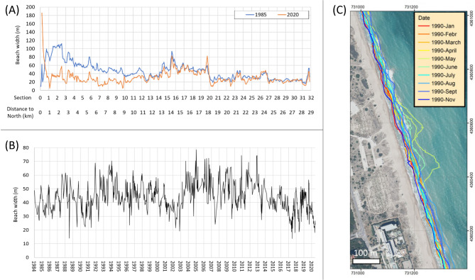
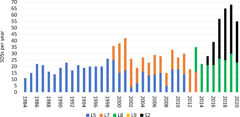
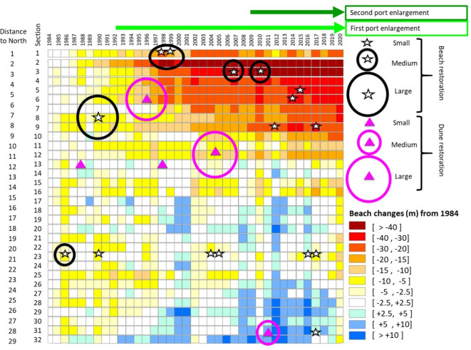
High costs and project-based (short-term) financing mean that coastal engineering projects are often undertaken in the absence of appropriate post-construction monitoring programmes. Consequently, the performance of shoreline-stabilizing structures or beach nourishments cannot be properly quantified. Given the high value of beaches and the increase in erosion problems and coastal engineering responses, managers require as much accurate data as possible to support efficient decision-making. This work presents a methodological approach to characterise coastline position changes as a result of engineering actions. We describe a new, low-cost method based on satellite remote sensing to monitor shoreline evolution at high temporal and spatial resolution pre-, during and post-implementation. Initially, satellite-derived waterlines are identified and extracted from publicly available satellite imagery of the Landsat 5, 7, 8, and 9, and Sentinel-2 constellations using the automatic shoreline extraction tool SHOREX. The waterline positions are then compiled, differences over time are quantified, and a matrix is constructed that allows easy depiction and interpretation of spatial and temporal patterns of erosion/accretion. This allows the access and the comprehension of the morphological data by the non-expert. Two examples of application on the Valencian coast of Spain at different spatial scales demonstrate how beach response to coastal engineering actions can be characterised at different levels of detail (from local to regional) and over different periods of time. These applications evidence the utility of the approach as it allows analysis of pre- and post-intervention coastal change and offers a means to overcome the widespread lack of monitoring and hence to improve coastal engineering practice.
期刊介绍:
We publish original research from all areas of the natural sciences, psychology, medicine and engineering. You can learn more about what we publish by browsing our specific scientific subject areas below or explore Scientific Reports by browsing all articles and collections.
Scientific Reports has a 2-year impact factor: 4.380 (2021), and is the 6th most-cited journal in the world, with more than 540,000 citations in 2020 (Clarivate Analytics, 2021).
•Engineering
Engineering covers all aspects of engineering, technology, and applied science. It plays a crucial role in the development of technologies to address some of the world''s biggest challenges, helping to save lives and improve the way we live.
•Physical sciences
Physical sciences are those academic disciplines that aim to uncover the underlying laws of nature — often written in the language of mathematics. It is a collective term for areas of study including astronomy, chemistry, materials science and physics.
•Earth and environmental sciences
Earth and environmental sciences cover all aspects of Earth and planetary science and broadly encompass solid Earth processes, surface and atmospheric dynamics, Earth system history, climate and climate change, marine and freshwater systems, and ecology. It also considers the interactions between humans and these systems.
•Biological sciences
Biological sciences encompass all the divisions of natural sciences examining various aspects of vital processes. The concept includes anatomy, physiology, cell biology, biochemistry and biophysics, and covers all organisms from microorganisms, animals to plants.
•Health sciences
The health sciences study health, disease and healthcare. This field of study aims to develop knowledge, interventions and technology for use in healthcare to improve the treatment of patients.

 求助内容:
求助内容: 应助结果提醒方式:


