基于多平台高光谱影像和深度回归网络的内陆水体养分污染制图

IF 11.3 1区 环境科学与生态学 Q1 ENGINEERING, ENVIRONMENTAL
Chao Niu , Kun Tan , Xue Wang , Chen Pan
{"title":"基于多平台高光谱影像和深度回归网络的内陆水体养分污染制图","authors":"Chao Niu ,&nbsp;Kun Tan ,&nbsp;Xue Wang ,&nbsp;Chen Pan","doi":"10.1016/j.jhazmat.2025.137314","DOIUrl":null,"url":null,"abstract":"<div><div>Inland waters face multiple threats from human activities and natural factors, leading to frequent water quality issues, particularly the significant challenge of eutrophication. Hyperspectral remote sensing provides rich spectral information, enabling timely and accurate assessment of water quality status and trends. To address the challenge of inaccurate water quality mapping, we propose a novel deep learning framework for multi-parameter estimation from hyperspectral imagery. A deep convolutional spatial-spectral joint learning method incorporating high-dimensional attention-weighted differences is proposed to optimize the deep features. The model was used to accurately estimate the distribution of three key eutrophication-related water quality parameters: total nitrogen, total phosphorus, and ammonia nitrogen. Through scale analysis, ablation experiments, and model comparisons, the results demonstrate stable regression performance with the proposed model. Specifically, the coefficient of determination (R2) values are 0.8315, 0.8137, and 0.8245, the mean absolute error (MAE) values are 0.2035, 0.0056 and 0.0134, and the mean squared error (MSE) values are 0.0733, 0.00008 and 0.0003 for the three parameters in the test set, respectively. Compared to the traditional feature analysis and regression methods, the R² values are improved by approximately 30 %, while the MAE and MSE values are reduced by approximately 60 % and 80 %, respectively. The model was applied to airborne hyperspectral imagery for nutrient pollution mapping. To assess the model’s generalizability, we applied the trained model to multi-temporal satellite hyperspectral imagery and validated against in situ monitoring data, where the proposed model demonstrated promising cross-platform and temporal transferability.</div></div>","PeriodicalId":361,"journal":{"name":"Journal of Hazardous Materials","volume":"488 ","pages":"Article 137314"},"PeriodicalIF":11.3000,"publicationDate":"2025-01-22","publicationTypes":"Journal Article","fieldsOfStudy":null,"isOpenAccess":false,"openAccessPdf":"","citationCount":"0","resultStr":"{\"title\":\"Mapping nutrient pollution in inland water bodies using multi-platform hyperspectral imagery and deep regression network\",\"authors\":\"Chao Niu ,&nbsp;Kun Tan ,&nbsp;Xue Wang ,&nbsp;Chen Pan\",\"doi\":\"10.1016/j.jhazmat.2025.137314\",\"DOIUrl\":null,\"url\":null,\"abstract\":\"<div><div>Inland waters face multiple threats from human activities and natural factors, leading to frequent water quality issues, particularly the significant challenge of eutrophication. Hyperspectral remote sensing provides rich spectral information, enabling timely and accurate assessment of water quality status and trends. To address the challenge of inaccurate water quality mapping, we propose a novel deep learning framework for multi-parameter estimation from hyperspectral imagery. A deep convolutional spatial-spectral joint learning method incorporating high-dimensional attention-weighted differences is proposed to optimize the deep features. The model was used to accurately estimate the distribution of three key eutrophication-related water quality parameters: total nitrogen, total phosphorus, and ammonia nitrogen. Through scale analysis, ablation experiments, and model comparisons, the results demonstrate stable regression performance with the proposed model. Specifically, the coefficient of determination (R2) values are 0.8315, 0.8137, and 0.8245, the mean absolute error (MAE) values are 0.2035, 0.0056 and 0.0134, and the mean squared error (MSE) values are 0.0733, 0.00008 and 0.0003 for the three parameters in the test set, respectively. Compared to the traditional feature analysis and regression methods, the R² values are improved by approximately 30 %, while the MAE and MSE values are reduced by approximately 60 % and 80 %, respectively. The model was applied to airborne hyperspectral imagery for nutrient pollution mapping. To assess the model’s generalizability, we applied the trained model to multi-temporal satellite hyperspectral imagery and validated against in situ monitoring data, where the proposed model demonstrated promising cross-platform and temporal transferability.</div></div>\",\"PeriodicalId\":361,\"journal\":{\"name\":\"Journal of Hazardous Materials\",\"volume\":\"488 \",\"pages\":\"Article 137314\"},\"PeriodicalIF\":11.3000,\"publicationDate\":\"2025-01-22\",\"publicationTypes\":\"Journal Article\",\"fieldsOfStudy\":null,\"isOpenAccess\":false,\"openAccessPdf\":\"\",\"citationCount\":\"0\",\"resultStr\":null,\"platform\":\"Semanticscholar\",\"paperid\":null,\"PeriodicalName\":\"Journal of Hazardous Materials\",\"FirstCategoryId\":\"93\",\"ListUrlMain\":\"https://www.sciencedirect.com/science/article/pii/S0304389425002262\",\"RegionNum\":1,\"RegionCategory\":\"环境科学与生态学\",\"ArticlePicture\":[],\"TitleCN\":null,\"AbstractTextCN\":null,\"PMCID\":null,\"EPubDate\":\"\",\"PubModel\":\"\",\"JCR\":\"Q1\",\"JCRName\":\"ENGINEERING, ENVIRONMENTAL\",\"Score\":null,\"Total\":0}","platform":"Semanticscholar","paperid":null,"PeriodicalName":"Journal of Hazardous Materials","FirstCategoryId":"93","ListUrlMain":"https://www.sciencedirect.com/science/article/pii/S0304389425002262","RegionNum":1,"RegionCategory":"环境科学与生态学","ArticlePicture":[],"TitleCN":null,"AbstractTextCN":null,"PMCID":null,"EPubDate":"","PubModel":"","JCR":"Q1","JCRName":"ENGINEERING, ENVIRONMENTAL","Score":null,"Total":0}
引用次数: 0

摘要

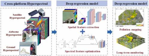
内陆水域面临人类活动和自然因素的多重威胁,导致水质问题频发,特别是富营养化的重大挑战。高光谱遥感提供了丰富的光谱信息,能够及时准确地评估水质状况和趋势。为了解决水质测绘不准确的挑战,我们提出了一种新的深度学习框架,用于从高光谱图像中进行多参数估计。提出了一种基于高维注意加权差分的深度卷积空间-频谱联合学习方法来优化深度特征。利用该模型准确估计了富营养化相关的3个关键水质参数:总氮、总磷和氨氮的分布。通过尺度分析、烧蚀实验和模型比较,结果表明该模型具有稳定的回归性能。其中,三个参数的决定系数(R2)值分别为0.8315、0.8137和0.8245,平均绝对误差(MAE)值分别为0.2035、0.0056和0.0134,均方误差(MSE)值分别为0.0733、0.00008和0.0003。与传统的特征分析和回归方法相比,R²值提高了约30%,MAE和MSE值分别降低了约60%和80%。将该模型应用于航空高光谱影像中进行营养物污染制图。为了评估模型的普遍性,我们将训练好的模型应用于多时相卫星高光谱图像,并针对现场监测数据进行验证,其中所提出的模型显示出良好的跨平台和时间可转移性。
本文章由计算机程序翻译,如有差异,请以英文原文为准。

Mapping nutrient pollution in inland water bodies using multi-platform hyperspectral imagery and deep regression network

Mapping nutrient pollution in inland water bodies using multi-platform hyperspectral imagery and deep regression network
Inland waters face multiple threats from human activities and natural factors, leading to frequent water quality issues, particularly the significant challenge of eutrophication. Hyperspectral remote sensing provides rich spectral information, enabling timely and accurate assessment of water quality status and trends. To address the challenge of inaccurate water quality mapping, we propose a novel deep learning framework for multi-parameter estimation from hyperspectral imagery. A deep convolutional spatial-spectral joint learning method incorporating high-dimensional attention-weighted differences is proposed to optimize the deep features. The model was used to accurately estimate the distribution of three key eutrophication-related water quality parameters: total nitrogen, total phosphorus, and ammonia nitrogen. Through scale analysis, ablation experiments, and model comparisons, the results demonstrate stable regression performance with the proposed model. Specifically, the coefficient of determination (R2) values are 0.8315, 0.8137, and 0.8245, the mean absolute error (MAE) values are 0.2035, 0.0056 and 0.0134, and the mean squared error (MSE) values are 0.0733, 0.00008 and 0.0003 for the three parameters in the test set, respectively. Compared to the traditional feature analysis and regression methods, the R² values are improved by approximately 30 %, while the MAE and MSE values are reduced by approximately 60 % and 80 %, respectively. The model was applied to airborne hyperspectral imagery for nutrient pollution mapping. To assess the model’s generalizability, we applied the trained model to multi-temporal satellite hyperspectral imagery and validated against in situ monitoring data, where the proposed model demonstrated promising cross-platform and temporal transferability.
求助全文
通过发布文献求助,成功后即可免费获取论文全文。 去求助
来源期刊
Journal of Hazardous Materials
Journal of Hazardous Materials 工程技术-工程:环境
CiteScore
25.40
自引率
5.90%
发文量
3059
审稿时长
58 days
期刊介绍: The Journal of Hazardous Materials serves as a global platform for promoting cutting-edge research in the field of Environmental Science and Engineering. Our publication features a wide range of articles, including full-length research papers, review articles, and perspectives, with the aim of enhancing our understanding of the dangers and risks associated with various materials concerning public health and the environment. It is important to note that the term "environmental contaminants" refers specifically to substances that pose hazardous effects through contamination, while excluding those that do not have such impacts on the environment or human health. Moreover, we emphasize the distinction between wastes and hazardous materials in order to provide further clarity on the scope of the journal. We have a keen interest in exploring specific compounds and microbial agents that have adverse effects on the environment.
×
引用
GB/T 7714-2015
复制
MLA
复制
APA
复制
导出至
BibTeX EndNote RefMan NoteFirst NoteExpress
×
提示
您的信息不完整,为了账户安全,请先补充。
现在去补充
×
提示
您因"违规操作"
具体请查看互助需知
我知道了
×
提示
确定
请完成安全验证×
copy
已复制链接
快去分享给好友吧!
我知道了
右上角分享
点击右上角分享
0
联系我们:info@booksci.cn Book学术提供免费学术资源搜索服务,方便国内外学者检索中英文文献。致力于提供最便捷和优质的服务体验。 Copyright © 2023 布克学术 All rights reserved.
京ICP备2023020795号-1
ghs 京公网安备 11010802042870号
Book学术文献互助
Book学术文献互助群
群 号:604180095
Book学术官方微信