将宇宙射线中子遥感数据整合到土壤水文模型中,提高公顷尺度地下水补给估算
IF 4.6
1区 地球科学
Q2 ENVIRONMENTAL SCIENCES
引用次数: 0
摘要
用状态变量校准的渗流带模型可能为推导地下水补给提供一种可靠的方法。宇宙射线中子感应(CRNS)提供大支持体积(公顷水平范围)上的土壤湿度,并提供在此尺度上估计水通量的机会。然而,该方法的水平和垂直敏感性导致其固有的加权含水量,这给其在土壤水文建模中的应用带来了挑战。我们系统地评估校准在HYDRUS 1D土壤水力模型在一个作物田现场。采用不同的田间尺度土壤湿度时间序列进行了校准,并评估了模型表征根区土壤湿度和推导地下水补给的能力。作为我们的基准,我们在CRNS的足迹内使用分布式点传感器网络。根据CRNS数据校准的模型或CRNS与更深点测量的组合得出的地下水累积补给与基准相当。虽然仅基于CRNS数据的模型不能充分代表根区土壤水分动态,但将CRNS与剖面土壤水分相结合克服了这一局限性。与基于土壤水张力测量的独立估计相比,基于CRNS数据校准的模型在确定向下通量的时间方面也表现良好。然而,后者提供了定量的地下水补给估算值,范围很广,包括超出当地年降水量的不切实际的高值。相反,基于分布式传感器网络或CRNS的模拟地下水补给估算值在年降水量的30%至40%之间。本文章由计算机程序翻译,如有差异,请以英文原文为准。
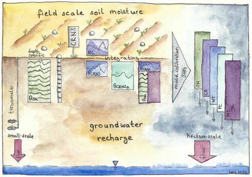
Enhancing Hectare-Scale Groundwater Recharge Estimation by Integrating Data From Cosmic-Ray Neutron Sensing Into Soil Hydrological Modeling
Vadose zone models, calibrated with state variables, may offer a robust approach for deriving groundwater recharge. Cosmic-ray neutron sensing (CRNS) provides soil moisture over a large support volume (horizontal extent of hectares) and offers the opportunity to estimate water fluxes at this scale. However, the horizontal and vertical sensitivity of the method results in an inherently weighted water content, which poses a challenge for its application in soil hydrologic modeling. We systematically assess calibrating a soil hydraulic model in HYDRUS 1D at a cropped field site. Calibration was performed using different field-scale soil moisture time series and the ability of the model to represent root zone soil moisture and derive groundwater recharge was assessed. As our benchmark, we used a distributed point sensor network from within the footprint of the CRNS. Models calibrated on CRNS data or combinations of CRNS with deeper point measurements resulted in cumulative groundwater recharge comparable to the benchmark. While models based exclusively on CRNS data do not represent the root zone soil moisture dynamics adequately, combining CRNS with profile soil moisture overcomes this limitation. Models calibrated on CRNS data also perform well in timing the downward flux compared to an independent estimate based on soil water tension measurements. However, the latter provides quantitative groundwater recharge estimates spanning a wide range of values, including unrealistic highs exceeding local annual precipitation. Conversely, modeled groundwater recharge based on the distributed sensor network or on CRNS resulted in estimates ranging between 30% and 40% of annual precipitation.
求助全文
通过发布文献求助,成功后即可免费获取论文全文。
去求助
来源期刊

Water Resources Research
环境科学-湖沼学
CiteScore
8.80
自引率
13.00%
发文量
599
审稿时长
3.5 months
期刊介绍:
Water Resources Research (WRR) is an interdisciplinary journal that focuses on hydrology and water resources. It publishes original research in the natural and social sciences of water. It emphasizes the role of water in the Earth system, including physical, chemical, biological, and ecological processes in water resources research and management, including social, policy, and public health implications. It encompasses observational, experimental, theoretical, analytical, numerical, and data-driven approaches that advance the science of water and its management. Submissions are evaluated for their novelty, accuracy, significance, and broader implications of the findings.
 求助内容:
求助内容: 应助结果提醒方式:


