Md Abrar Istiak, Razib Hayat Khan, Jahid Hasan Rony, M M Mahbubul Syeed, M Ashrafuzzaman, Md Rajaul Karim, Md Shakhawat Hossain, Mohammad Faisal Uddin
{"title":"AqUavplant数据集:基于无人机的高分辨率水生植物分类分割图像数据集。","authors":"Md Abrar Istiak, Razib Hayat Khan, Jahid Hasan Rony, M M Mahbubul Syeed, M Ashrafuzzaman, Md Rajaul Karim, Md Shakhawat Hossain, Mohammad Faisal Uddin","doi":"10.1038/s41597-024-04155-6","DOIUrl":null,"url":null,"abstract":"<p><p>Aquatic vegetation species are declining gradually, posing a threat to the stability of aquatic ecosystems. The decline can be controlled with proper monitoring and mapping of the species for effective conservation and management. The Unmanned Ariel Vehicle (UAV) aka Drone can be deployed to comprehensively capture large area of water bodies for effective mapping and monitoring. This study developed the AqUavplant dataset consisting of 197 high resolution (3840px × 2160px, 4K) images of 31 aquatic plant species collected from nine different sites in Bangladesh. The DJI Mavic 3 Pro triple-camera professional drone is used with a ground sampling distance (GSD) value of 0.04-0.05 cm/px for optimal image collection without losing detail. The dataset is complemented with binary and multiclass semantic segmentation mask to facilitate ML based model development for automatic plant mapping. The dataset can be used to detect the diversity of indigenous and invasive species, monitor plant growth and diseases, measure the growth ratio to preserve biodiversity, and prevent extinction.</p>","PeriodicalId":21597,"journal":{"name":"Scientific Data","volume":"11 1","pages":"1411"},"PeriodicalIF":6.9000,"publicationDate":"2024-12-20","publicationTypes":"Journal Article","fieldsOfStudy":null,"isOpenAccess":false,"openAccessPdf":"https://www.ncbi.nlm.nih.gov/pmc/articles/PMC11661991/pdf/","citationCount":"0","resultStr":"{\"title\":\"AqUavplant Dataset: A High-Resolution Aquatic Plant Classification and Segmentation Image Dataset Using UAV.\",\"authors\":\"Md Abrar Istiak, Razib Hayat Khan, Jahid Hasan Rony, M M Mahbubul Syeed, M Ashrafuzzaman, Md Rajaul Karim, Md Shakhawat Hossain, Mohammad Faisal Uddin\",\"doi\":\"10.1038/s41597-024-04155-6\",\"DOIUrl\":null,\"url\":null,\"abstract\":\"<p><p>Aquatic vegetation species are declining gradually, posing a threat to the stability of aquatic ecosystems. The decline can be controlled with proper monitoring and mapping of the species for effective conservation and management. The Unmanned Ariel Vehicle (UAV) aka Drone can be deployed to comprehensively capture large area of water bodies for effective mapping and monitoring. This study developed the AqUavplant dataset consisting of 197 high resolution (3840px × 2160px, 4K) images of 31 aquatic plant species collected from nine different sites in Bangladesh. The DJI Mavic 3 Pro triple-camera professional drone is used with a ground sampling distance (GSD) value of 0.04-0.05 cm/px for optimal image collection without losing detail. The dataset is complemented with binary and multiclass semantic segmentation mask to facilitate ML based model development for automatic plant mapping. The dataset can be used to detect the diversity of indigenous and invasive species, monitor plant growth and diseases, measure the growth ratio to preserve biodiversity, and prevent extinction.</p>\",\"PeriodicalId\":21597,\"journal\":{\"name\":\"Scientific Data\",\"volume\":\"11 1\",\"pages\":\"1411\"},\"PeriodicalIF\":6.9000,\"publicationDate\":\"2024-12-20\",\"publicationTypes\":\"Journal Article\",\"fieldsOfStudy\":null,\"isOpenAccess\":false,\"openAccessPdf\":\"https://www.ncbi.nlm.nih.gov/pmc/articles/PMC11661991/pdf/\",\"citationCount\":\"0\",\"resultStr\":null,\"platform\":\"Semanticscholar\",\"paperid\":null,\"PeriodicalName\":\"Scientific Data\",\"FirstCategoryId\":\"103\",\"ListUrlMain\":\"https://doi.org/10.1038/s41597-024-04155-6\",\"RegionNum\":2,\"RegionCategory\":\"综合性期刊\",\"ArticlePicture\":[],\"TitleCN\":null,\"AbstractTextCN\":null,\"PMCID\":null,\"EPubDate\":\"\",\"PubModel\":\"\",\"JCR\":\"Q1\",\"JCRName\":\"MULTIDISCIPLINARY SCIENCES\",\"Score\":null,\"Total\":0}","platform":"Semanticscholar","paperid":null,"PeriodicalName":"Scientific Data","FirstCategoryId":"103","ListUrlMain":"https://doi.org/10.1038/s41597-024-04155-6","RegionNum":2,"RegionCategory":"综合性期刊","ArticlePicture":[],"TitleCN":null,"AbstractTextCN":null,"PMCID":null,"EPubDate":"","PubModel":"","JCR":"Q1","JCRName":"MULTIDISCIPLINARY SCIENCES","Score":null,"Total":0}
AqUavplant Dataset: A High-Resolution Aquatic Plant Classification and Segmentation Image Dataset Using UAV.
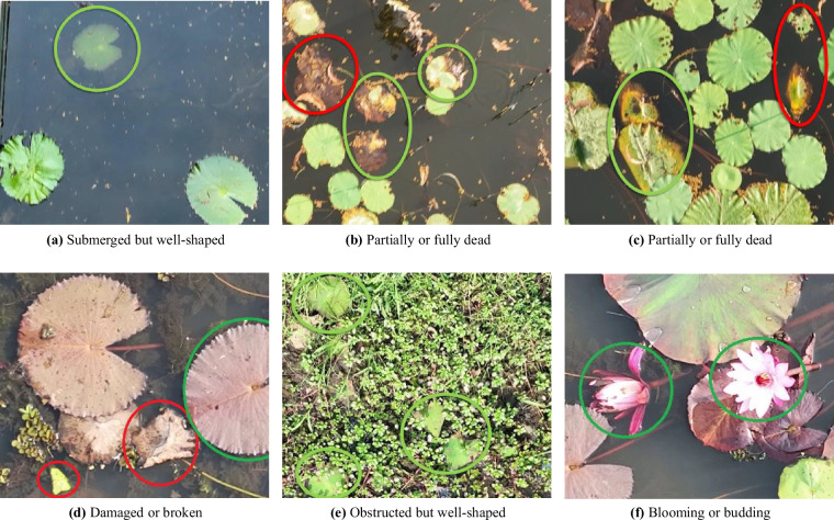
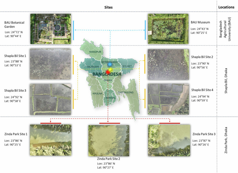
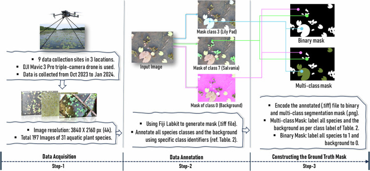
Aquatic vegetation species are declining gradually, posing a threat to the stability of aquatic ecosystems. The decline can be controlled with proper monitoring and mapping of the species for effective conservation and management. The Unmanned Ariel Vehicle (UAV) aka Drone can be deployed to comprehensively capture large area of water bodies for effective mapping and monitoring. This study developed the AqUavplant dataset consisting of 197 high resolution (3840px × 2160px, 4K) images of 31 aquatic plant species collected from nine different sites in Bangladesh. The DJI Mavic 3 Pro triple-camera professional drone is used with a ground sampling distance (GSD) value of 0.04-0.05 cm/px for optimal image collection without losing detail. The dataset is complemented with binary and multiclass semantic segmentation mask to facilitate ML based model development for automatic plant mapping. The dataset can be used to detect the diversity of indigenous and invasive species, monitor plant growth and diseases, measure the growth ratio to preserve biodiversity, and prevent extinction.
期刊介绍:
Scientific Data is an open-access journal focused on data, publishing descriptions of research datasets and articles on data sharing across natural sciences, medicine, engineering, and social sciences. Its goal is to enhance the sharing and reuse of scientific data, encourage broader data sharing, and acknowledge those who share their data.
The journal primarily publishes Data Descriptors, which offer detailed descriptions of research datasets, including data collection methods and technical analyses validating data quality. These descriptors aim to facilitate data reuse rather than testing hypotheses or presenting new interpretations, methods, or in-depth analyses.
 求助内容:
求助内容: 应助结果提醒方式:


