F. Koch, S. Gascoin, K. Achmüller, P. Schattan, K.-F. Wetzel, C. Deschamps-Berger, M. Lehning, T. Rehm, K. Schulz, C. Voigt
{"title":"超导重力仪观测结果表明,卫星得出的雪深图像改进了对高山地区雪水当量演变的模拟","authors":"F. Koch, S. Gascoin, K. Achmüller, P. Schattan, K.-F. Wetzel, C. Deschamps-Berger, M. Lehning, T. Rehm, K. Schulz, C. Voigt","doi":"10.1029/2024GL112483","DOIUrl":null,"url":null,"abstract":"<p>The lack of accurate information on the spatiotemporal variations of snow water equivalent (SWE) in mountain catchments remains a key problem in snow hydrology and water resources management. This is partly because there is no sensor to measure SWE beyond local scale. At Mt. Zugspitze, Germany, a superconducting gravimeter senses the gravity effect of the seasonal snow, reflecting the temporal evolution of SWE in a few kilometers scale radius. We used this new observation to evaluate two configurations of the Alpine3D distributed snow model. In the default run, the model was forced with meteorological station data. In the second run, we applied precipitation correction based on an 8 m resolution snow depth image derived from satellite observations (Pléiades). The snow depth image strongly improved the simulation of the snowpack gravity effect during the melt season. This result suggests that satellite observations can enhance SWE analyses in mountains with limited infrastructure.</p>","PeriodicalId":12523,"journal":{"name":"Geophysical Research Letters","volume":"51 24","pages":""},"PeriodicalIF":4.6000,"publicationDate":"2024-12-20","publicationTypes":"Journal Article","fieldsOfStudy":null,"isOpenAccess":false,"openAccessPdf":"https://onlinelibrary.wiley.com/doi/epdf/10.1029/2024GL112483","citationCount":"0","resultStr":"{\"title\":\"Superconducting Gravimeter Observations Show That a Satellite-Derived Snow Depth Image Improves the Simulation of the Snow Water Equivalent Evolution in a High Alpine Site\",\"authors\":\"F. Koch, S. Gascoin, K. Achmüller, P. Schattan, K.-F. Wetzel, C. Deschamps-Berger, M. Lehning, T. Rehm, K. Schulz, C. Voigt\",\"doi\":\"10.1029/2024GL112483\",\"DOIUrl\":null,\"url\":null,\"abstract\":\"<p>The lack of accurate information on the spatiotemporal variations of snow water equivalent (SWE) in mountain catchments remains a key problem in snow hydrology and water resources management. This is partly because there is no sensor to measure SWE beyond local scale. At Mt. Zugspitze, Germany, a superconducting gravimeter senses the gravity effect of the seasonal snow, reflecting the temporal evolution of SWE in a few kilometers scale radius. We used this new observation to evaluate two configurations of the Alpine3D distributed snow model. In the default run, the model was forced with meteorological station data. In the second run, we applied precipitation correction based on an 8 m resolution snow depth image derived from satellite observations (Pléiades). The snow depth image strongly improved the simulation of the snowpack gravity effect during the melt season. This result suggests that satellite observations can enhance SWE analyses in mountains with limited infrastructure.</p>\",\"PeriodicalId\":12523,\"journal\":{\"name\":\"Geophysical Research Letters\",\"volume\":\"51 24\",\"pages\":\"\"},\"PeriodicalIF\":4.6000,\"publicationDate\":\"2024-12-20\",\"publicationTypes\":\"Journal Article\",\"fieldsOfStudy\":null,\"isOpenAccess\":false,\"openAccessPdf\":\"https://onlinelibrary.wiley.com/doi/epdf/10.1029/2024GL112483\",\"citationCount\":\"0\",\"resultStr\":null,\"platform\":\"Semanticscholar\",\"paperid\":null,\"PeriodicalName\":\"Geophysical Research Letters\",\"FirstCategoryId\":\"89\",\"ListUrlMain\":\"https://agupubs.onlinelibrary.wiley.com/doi/10.1029/2024GL112483\",\"RegionNum\":1,\"RegionCategory\":\"地球科学\",\"ArticlePicture\":[],\"TitleCN\":null,\"AbstractTextCN\":null,\"PMCID\":null,\"EPubDate\":\"\",\"PubModel\":\"\",\"JCR\":\"Q1\",\"JCRName\":\"GEOSCIENCES, MULTIDISCIPLINARY\",\"Score\":null,\"Total\":0}","platform":"Semanticscholar","paperid":null,"PeriodicalName":"Geophysical Research Letters","FirstCategoryId":"89","ListUrlMain":"https://agupubs.onlinelibrary.wiley.com/doi/10.1029/2024GL112483","RegionNum":1,"RegionCategory":"地球科学","ArticlePicture":[],"TitleCN":null,"AbstractTextCN":null,"PMCID":null,"EPubDate":"","PubModel":"","JCR":"Q1","JCRName":"GEOSCIENCES, MULTIDISCIPLINARY","Score":null,"Total":0}
Superconducting Gravimeter Observations Show That a Satellite-Derived Snow Depth Image Improves the Simulation of the Snow Water Equivalent Evolution in a High Alpine Site
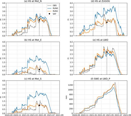
The lack of accurate information on the spatiotemporal variations of snow water equivalent (SWE) in mountain catchments remains a key problem in snow hydrology and water resources management. This is partly because there is no sensor to measure SWE beyond local scale. At Mt. Zugspitze, Germany, a superconducting gravimeter senses the gravity effect of the seasonal snow, reflecting the temporal evolution of SWE in a few kilometers scale radius. We used this new observation to evaluate two configurations of the Alpine3D distributed snow model. In the default run, the model was forced with meteorological station data. In the second run, we applied precipitation correction based on an 8 m resolution snow depth image derived from satellite observations (Pléiades). The snow depth image strongly improved the simulation of the snowpack gravity effect during the melt season. This result suggests that satellite observations can enhance SWE analyses in mountains with limited infrastructure.
期刊介绍:
Geophysical Research Letters (GRL) publishes high-impact, innovative, and timely research on major scientific advances in all the major geoscience disciplines. Papers are communications-length articles and should have broad and immediate implications in their discipline or across the geosciences. GRLmaintains the fastest turn-around of all high-impact publications in the geosciences and works closely with authors to ensure broad visibility of top papers.

 求助内容:
求助内容: 应助结果提醒方式:


