Idrissa Nonmon Sanogo, Maxime Fusade-Boyer, Sophie Molia, Ousmane A Koita, Christelle Camus, Mariette F Ducatez
{"title":"利用GIS-MCDA方法确定马里家禽中禽流感暴发的危险区。","authors":"Idrissa Nonmon Sanogo, Maxime Fusade-Boyer, Sophie Molia, Ousmane A Koita, Christelle Camus, Mariette F Ducatez","doi":"10.1017/S0950268824001390","DOIUrl":null,"url":null,"abstract":"<p><p>Mali is a country where little information is known about the circulation of avian influenza viruses (AIVs) in poultry. Implementing risk-based surveillance strategies would allow early detection and rapid control of AIVs outbreaks in the country. In this study, we implemented a multi-criteria decision analysis (MCDA) method coupled with geographic information systems (GIS) to identify risk areas for AIVs occurrence in domestic poultry in Mali. Five risk factors associated with AIVs occurrence were identified from the literature, and their relative weights were determined using the analytic hierarchy process (AHP). Spatial data were collected for each risk factor and processed to produce risk maps for AIVs outbreaks using a weighted linear combination (WLC). We identified the southeast regions (Bamako and Sikasso) and the central region (Mopti) as areas with the highest risk of AIVs occurrence. Conversely, northern regions were considered low-risk areas. The risk areas agree with the location of HPAI outbreaks in Mali. This study provides the first risk map using the GIS-MCDA approach to identify risk areas for AIVs occurrence in Mali. It should provide a basis for designing risk-based and more cost-effective surveillance strategies for the early detection of avian influenza outbreaks in Mali.</p>","PeriodicalId":11721,"journal":{"name":"Epidemiology and Infection","volume":"152 ","pages":"e152"},"PeriodicalIF":2.2000,"publicationDate":"2024-12-02","publicationTypes":"Journal Article","fieldsOfStudy":null,"isOpenAccess":false,"openAccessPdf":"https://www.ncbi.nlm.nih.gov/pmc/articles/PMC11626446/pdf/","citationCount":"0","resultStr":"{\"title\":\"Identification of risk areas for avian influenza outbreaks in domestic poultry in Mali using the GIS-MCDA approach.\",\"authors\":\"Idrissa Nonmon Sanogo, Maxime Fusade-Boyer, Sophie Molia, Ousmane A Koita, Christelle Camus, Mariette F Ducatez\",\"doi\":\"10.1017/S0950268824001390\",\"DOIUrl\":null,\"url\":null,\"abstract\":\"<p><p>Mali is a country where little information is known about the circulation of avian influenza viruses (AIVs) in poultry. Implementing risk-based surveillance strategies would allow early detection and rapid control of AIVs outbreaks in the country. In this study, we implemented a multi-criteria decision analysis (MCDA) method coupled with geographic information systems (GIS) to identify risk areas for AIVs occurrence in domestic poultry in Mali. Five risk factors associated with AIVs occurrence were identified from the literature, and their relative weights were determined using the analytic hierarchy process (AHP). Spatial data were collected for each risk factor and processed to produce risk maps for AIVs outbreaks using a weighted linear combination (WLC). We identified the southeast regions (Bamako and Sikasso) and the central region (Mopti) as areas with the highest risk of AIVs occurrence. Conversely, northern regions were considered low-risk areas. The risk areas agree with the location of HPAI outbreaks in Mali. This study provides the first risk map using the GIS-MCDA approach to identify risk areas for AIVs occurrence in Mali. It should provide a basis for designing risk-based and more cost-effective surveillance strategies for the early detection of avian influenza outbreaks in Mali.</p>\",\"PeriodicalId\":11721,\"journal\":{\"name\":\"Epidemiology and Infection\",\"volume\":\"152 \",\"pages\":\"e152\"},\"PeriodicalIF\":2.2000,\"publicationDate\":\"2024-12-02\",\"publicationTypes\":\"Journal Article\",\"fieldsOfStudy\":null,\"isOpenAccess\":false,\"openAccessPdf\":\"https://www.ncbi.nlm.nih.gov/pmc/articles/PMC11626446/pdf/\",\"citationCount\":\"0\",\"resultStr\":null,\"platform\":\"Semanticscholar\",\"paperid\":null,\"PeriodicalName\":\"Epidemiology and Infection\",\"FirstCategoryId\":\"3\",\"ListUrlMain\":\"https://doi.org/10.1017/S0950268824001390\",\"RegionNum\":4,\"RegionCategory\":\"医学\",\"ArticlePicture\":[],\"TitleCN\":null,\"AbstractTextCN\":null,\"PMCID\":null,\"EPubDate\":\"\",\"PubModel\":\"\",\"JCR\":\"Q3\",\"JCRName\":\"INFECTIOUS DISEASES\",\"Score\":null,\"Total\":0}","platform":"Semanticscholar","paperid":null,"PeriodicalName":"Epidemiology and Infection","FirstCategoryId":"3","ListUrlMain":"https://doi.org/10.1017/S0950268824001390","RegionNum":4,"RegionCategory":"医学","ArticlePicture":[],"TitleCN":null,"AbstractTextCN":null,"PMCID":null,"EPubDate":"","PubModel":"","JCR":"Q3","JCRName":"INFECTIOUS DISEASES","Score":null,"Total":0}
Identification of risk areas for avian influenza outbreaks in domestic poultry in Mali using the GIS-MCDA approach.
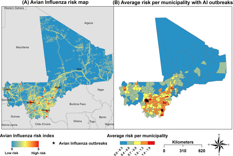
Mali is a country where little information is known about the circulation of avian influenza viruses (AIVs) in poultry. Implementing risk-based surveillance strategies would allow early detection and rapid control of AIVs outbreaks in the country. In this study, we implemented a multi-criteria decision analysis (MCDA) method coupled with geographic information systems (GIS) to identify risk areas for AIVs occurrence in domestic poultry in Mali. Five risk factors associated with AIVs occurrence were identified from the literature, and their relative weights were determined using the analytic hierarchy process (AHP). Spatial data were collected for each risk factor and processed to produce risk maps for AIVs outbreaks using a weighted linear combination (WLC). We identified the southeast regions (Bamako and Sikasso) and the central region (Mopti) as areas with the highest risk of AIVs occurrence. Conversely, northern regions were considered low-risk areas. The risk areas agree with the location of HPAI outbreaks in Mali. This study provides the first risk map using the GIS-MCDA approach to identify risk areas for AIVs occurrence in Mali. It should provide a basis for designing risk-based and more cost-effective surveillance strategies for the early detection of avian influenza outbreaks in Mali.
期刊介绍:
Epidemiology & Infection publishes original reports and reviews on all aspects of infection in humans and animals. Particular emphasis is given to the epidemiology, prevention and control of infectious diseases. The scope covers the zoonoses, outbreaks, food hygiene, vaccine studies, statistics and the clinical, social and public-health aspects of infectious disease, as well as some tropical infections. It has become the key international periodical in which to find the latest reports on recently discovered infections and new technology. For those concerned with policy and planning for the control of infections, the papers on mathematical modelling of epidemics caused by historical, current and emergent infections are of particular value.
 求助内容:
求助内容: 应助结果提醒方式:


