Zhihua Mao, Yang Zhang, Lingbing Bu, Qin Wang, Wei Xiao, Xuhui Lee, Dingyuan Liang, Khalid Muhammad Burhan, Jiqiao Liu, Weibiao Chen, Sihan Liu, Zhongting Wang
{"title":"用星载IPDA激光雷达测量云顶上方CO2柱浓度","authors":"Zhihua Mao, Yang Zhang, Lingbing Bu, Qin Wang, Wei Xiao, Xuhui Lee, Dingyuan Liang, Khalid Muhammad Burhan, Jiqiao Liu, Weibiao Chen, Sihan Liu, Zhongting Wang","doi":"10.1029/2024GL113309","DOIUrl":null,"url":null,"abstract":"<p>The Atmospheric Environment Monitoring Satellite (AEMS), launched by China in 2022, was equipped with active remote sensing lidar for carbon monitoring. It adopts the Integrated Path Differential Absorption (IPDA) technology to monitor global CO<sub>2</sub> column concentration (XCO<sub>2</sub>). The calculation of cloud top XCO<sub>2</sub> requires cloud height data. A comparison between SRTM global elevation data and 1,572 nm channel elevation data reveals a coefficient of determination (R<sup>2</sup>) of 0.998, with an average deviation of 1.24 m. The cloud top XCO<sub>2</sub> observations are consistent with the OCO-2 and CarbonTracker trends. The ocean carbon uptake rate, assessed by the difference in CO<sub>2</sub> concentration between cloud top and sea surface, is −0.319 mmol/m<sup>2</sup>/h, which is in good agreement with the associated carbon flux data. This demonstrates the great potential of IPDA lidar for remote sensing of cloud top CO<sub>2</sub> and quantifying ocean carbon uptake.</p>","PeriodicalId":12523,"journal":{"name":"Geophysical Research Letters","volume":"51 23","pages":""},"PeriodicalIF":4.6000,"publicationDate":"2024-11-29","publicationTypes":"Journal Article","fieldsOfStudy":null,"isOpenAccess":false,"openAccessPdf":"https://onlinelibrary.wiley.com/doi/epdf/10.1029/2024GL113309","citationCount":"0","resultStr":"{\"title\":\"Measurement of CO2 Column Concentration Above Cloud Tops With a Spaceborne IPDA Lidar\",\"authors\":\"Zhihua Mao, Yang Zhang, Lingbing Bu, Qin Wang, Wei Xiao, Xuhui Lee, Dingyuan Liang, Khalid Muhammad Burhan, Jiqiao Liu, Weibiao Chen, Sihan Liu, Zhongting Wang\",\"doi\":\"10.1029/2024GL113309\",\"DOIUrl\":null,\"url\":null,\"abstract\":\"<p>The Atmospheric Environment Monitoring Satellite (AEMS), launched by China in 2022, was equipped with active remote sensing lidar for carbon monitoring. It adopts the Integrated Path Differential Absorption (IPDA) technology to monitor global CO<sub>2</sub> column concentration (XCO<sub>2</sub>). The calculation of cloud top XCO<sub>2</sub> requires cloud height data. A comparison between SRTM global elevation data and 1,572 nm channel elevation data reveals a coefficient of determination (R<sup>2</sup>) of 0.998, with an average deviation of 1.24 m. The cloud top XCO<sub>2</sub> observations are consistent with the OCO-2 and CarbonTracker trends. The ocean carbon uptake rate, assessed by the difference in CO<sub>2</sub> concentration between cloud top and sea surface, is −0.319 mmol/m<sup>2</sup>/h, which is in good agreement with the associated carbon flux data. This demonstrates the great potential of IPDA lidar for remote sensing of cloud top CO<sub>2</sub> and quantifying ocean carbon uptake.</p>\",\"PeriodicalId\":12523,\"journal\":{\"name\":\"Geophysical Research Letters\",\"volume\":\"51 23\",\"pages\":\"\"},\"PeriodicalIF\":4.6000,\"publicationDate\":\"2024-11-29\",\"publicationTypes\":\"Journal Article\",\"fieldsOfStudy\":null,\"isOpenAccess\":false,\"openAccessPdf\":\"https://onlinelibrary.wiley.com/doi/epdf/10.1029/2024GL113309\",\"citationCount\":\"0\",\"resultStr\":null,\"platform\":\"Semanticscholar\",\"paperid\":null,\"PeriodicalName\":\"Geophysical Research Letters\",\"FirstCategoryId\":\"89\",\"ListUrlMain\":\"https://agupubs.onlinelibrary.wiley.com/doi/10.1029/2024GL113309\",\"RegionNum\":1,\"RegionCategory\":\"地球科学\",\"ArticlePicture\":[],\"TitleCN\":null,\"AbstractTextCN\":null,\"PMCID\":null,\"EPubDate\":\"\",\"PubModel\":\"\",\"JCR\":\"Q1\",\"JCRName\":\"GEOSCIENCES, MULTIDISCIPLINARY\",\"Score\":null,\"Total\":0}","platform":"Semanticscholar","paperid":null,"PeriodicalName":"Geophysical Research Letters","FirstCategoryId":"89","ListUrlMain":"https://agupubs.onlinelibrary.wiley.com/doi/10.1029/2024GL113309","RegionNum":1,"RegionCategory":"地球科学","ArticlePicture":[],"TitleCN":null,"AbstractTextCN":null,"PMCID":null,"EPubDate":"","PubModel":"","JCR":"Q1","JCRName":"GEOSCIENCES, MULTIDISCIPLINARY","Score":null,"Total":0}
Measurement of CO2 Column Concentration Above Cloud Tops With a Spaceborne IPDA Lidar
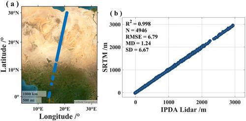
The Atmospheric Environment Monitoring Satellite (AEMS), launched by China in 2022, was equipped with active remote sensing lidar for carbon monitoring. It adopts the Integrated Path Differential Absorption (IPDA) technology to monitor global CO2 column concentration (XCO2). The calculation of cloud top XCO2 requires cloud height data. A comparison between SRTM global elevation data and 1,572 nm channel elevation data reveals a coefficient of determination (R2) of 0.998, with an average deviation of 1.24 m. The cloud top XCO2 observations are consistent with the OCO-2 and CarbonTracker trends. The ocean carbon uptake rate, assessed by the difference in CO2 concentration between cloud top and sea surface, is −0.319 mmol/m2/h, which is in good agreement with the associated carbon flux data. This demonstrates the great potential of IPDA lidar for remote sensing of cloud top CO2 and quantifying ocean carbon uptake.
期刊介绍:
Geophysical Research Letters (GRL) publishes high-impact, innovative, and timely research on major scientific advances in all the major geoscience disciplines. Papers are communications-length articles and should have broad and immediate implications in their discipline or across the geosciences. GRLmaintains the fastest turn-around of all high-impact publications in the geosciences and works closely with authors to ensure broad visibility of top papers.

 求助内容:
求助内容: 应助结果提醒方式:


