Jana Marešová, Petr Bašta, Kateřina Gdulová, Vojtěch Barták, Giorgi Kozhoridze, Jiri Šmída, Yannis Markonis, Duccio Rocchini, Jiří Prošek, Petra Pracná, Vítězslav Moudrý
{"title":"选择最优的全球数字高程模型用于水系圈定:超越垂直精度","authors":"Jana Marešová, Petr Bašta, Kateřina Gdulová, Vojtěch Barták, Giorgi Kozhoridze, Jiri Šmída, Yannis Markonis, Duccio Rocchini, Jiří Prošek, Petra Pracná, Vítězslav Moudrý","doi":"10.1029/2024EA003743","DOIUrl":null,"url":null,"abstract":"<div>\n \n \n <section>\n \n <p>Satellite-derived global digital elevation models (DEMs) are essential for providing the topographic information needed in a wide range of hydrological applications. However, their use is limited by spatial resolution and vertical bias due to sensor limitations in observing bare terrain. Significant efforts have been made to improve the resolution of global DEMs (e.g., TanDEM-X) and create bare-earth DEMs (e.g., FABDEM, MERIT, CEDTM). We evaluated the vertical accuracy of bare-earth and global DEMs in Central European mountains and submontane regions, and assessed how DEM resolution, vegetation offset removal, land cover, and terrain slope affect stream network delineation. Using lidar-derived DTM and national stream networks as references, we found that: (a) bare-earth DEMs outperform global DEMs across all land cover types. RMSEs increased with increasing slope for all DEMs in non-forest areas. In forests, however, the negative effect of the slope was outweighed by the vegetation offset even for bare-earth DTMs; (b) the accuracy of derived stream networks was affected by terrain slope and land cover more than by the vertical accuracy of DEMs. Stream network delineation performed poorly in non-forest areas and relatively well in forests. Increasing slope improved the streams delineation performance; (c) using DEMs with higher resolution (e.g., 12 m TanDEM-X) improved stream network delineation, but increasing resolution also increased the need for effective vegetation bias removal. Our results indicate that vertical accuracy alone does not reflect how well DEMs perform in stream network delineation. This underscores the need to include stream network performance in DEM quality rankings.</p>\n </section>\n </div>","PeriodicalId":54286,"journal":{"name":"Earth and Space Science","volume":"11 12","pages":""},"PeriodicalIF":2.9000,"publicationDate":"2024-11-27","publicationTypes":"Journal Article","fieldsOfStudy":null,"isOpenAccess":false,"openAccessPdf":"https://onlinelibrary.wiley.com/doi/epdf/10.1029/2024EA003743","citationCount":"0","resultStr":"{\"title\":\"Choosing the Optimal Global Digital Elevation Model for Stream Network Delineation: Beyond Vertical Accuracy\",\"authors\":\"Jana Marešová, Petr Bašta, Kateřina Gdulová, Vojtěch Barták, Giorgi Kozhoridze, Jiri Šmída, Yannis Markonis, Duccio Rocchini, Jiří Prošek, Petra Pracná, Vítězslav Moudrý\",\"doi\":\"10.1029/2024EA003743\",\"DOIUrl\":null,\"url\":null,\"abstract\":\"<div>\\n \\n \\n <section>\\n \\n <p>Satellite-derived global digital elevation models (DEMs) are essential for providing the topographic information needed in a wide range of hydrological applications. However, their use is limited by spatial resolution and vertical bias due to sensor limitations in observing bare terrain. Significant efforts have been made to improve the resolution of global DEMs (e.g., TanDEM-X) and create bare-earth DEMs (e.g., FABDEM, MERIT, CEDTM). We evaluated the vertical accuracy of bare-earth and global DEMs in Central European mountains and submontane regions, and assessed how DEM resolution, vegetation offset removal, land cover, and terrain slope affect stream network delineation. Using lidar-derived DTM and national stream networks as references, we found that: (a) bare-earth DEMs outperform global DEMs across all land cover types. RMSEs increased with increasing slope for all DEMs in non-forest areas. In forests, however, the negative effect of the slope was outweighed by the vegetation offset even for bare-earth DTMs; (b) the accuracy of derived stream networks was affected by terrain slope and land cover more than by the vertical accuracy of DEMs. Stream network delineation performed poorly in non-forest areas and relatively well in forests. Increasing slope improved the streams delineation performance; (c) using DEMs with higher resolution (e.g., 12 m TanDEM-X) improved stream network delineation, but increasing resolution also increased the need for effective vegetation bias removal. Our results indicate that vertical accuracy alone does not reflect how well DEMs perform in stream network delineation. This underscores the need to include stream network performance in DEM quality rankings.</p>\\n </section>\\n </div>\",\"PeriodicalId\":54286,\"journal\":{\"name\":\"Earth and Space Science\",\"volume\":\"11 12\",\"pages\":\"\"},\"PeriodicalIF\":2.9000,\"publicationDate\":\"2024-11-27\",\"publicationTypes\":\"Journal Article\",\"fieldsOfStudy\":null,\"isOpenAccess\":false,\"openAccessPdf\":\"https://onlinelibrary.wiley.com/doi/epdf/10.1029/2024EA003743\",\"citationCount\":\"0\",\"resultStr\":null,\"platform\":\"Semanticscholar\",\"paperid\":null,\"PeriodicalName\":\"Earth and Space Science\",\"FirstCategoryId\":\"89\",\"ListUrlMain\":\"https://onlinelibrary.wiley.com/doi/10.1029/2024EA003743\",\"RegionNum\":3,\"RegionCategory\":\"地球科学\",\"ArticlePicture\":[],\"TitleCN\":null,\"AbstractTextCN\":null,\"PMCID\":null,\"EPubDate\":\"\",\"PubModel\":\"\",\"JCR\":\"Q2\",\"JCRName\":\"ASTRONOMY & ASTROPHYSICS\",\"Score\":null,\"Total\":0}","platform":"Semanticscholar","paperid":null,"PeriodicalName":"Earth and Space Science","FirstCategoryId":"89","ListUrlMain":"https://onlinelibrary.wiley.com/doi/10.1029/2024EA003743","RegionNum":3,"RegionCategory":"地球科学","ArticlePicture":[],"TitleCN":null,"AbstractTextCN":null,"PMCID":null,"EPubDate":"","PubModel":"","JCR":"Q2","JCRName":"ASTRONOMY & ASTROPHYSICS","Score":null,"Total":0}
Choosing the Optimal Global Digital Elevation Model for Stream Network Delineation: Beyond Vertical Accuracy
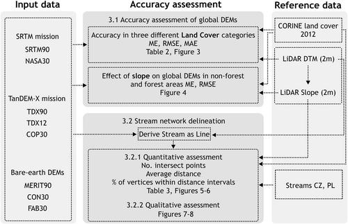
Satellite-derived global digital elevation models (DEMs) are essential for providing the topographic information needed in a wide range of hydrological applications. However, their use is limited by spatial resolution and vertical bias due to sensor limitations in observing bare terrain. Significant efforts have been made to improve the resolution of global DEMs (e.g., TanDEM-X) and create bare-earth DEMs (e.g., FABDEM, MERIT, CEDTM). We evaluated the vertical accuracy of bare-earth and global DEMs in Central European mountains and submontane regions, and assessed how DEM resolution, vegetation offset removal, land cover, and terrain slope affect stream network delineation. Using lidar-derived DTM and national stream networks as references, we found that: (a) bare-earth DEMs outperform global DEMs across all land cover types. RMSEs increased with increasing slope for all DEMs in non-forest areas. In forests, however, the negative effect of the slope was outweighed by the vegetation offset even for bare-earth DTMs; (b) the accuracy of derived stream networks was affected by terrain slope and land cover more than by the vertical accuracy of DEMs. Stream network delineation performed poorly in non-forest areas and relatively well in forests. Increasing slope improved the streams delineation performance; (c) using DEMs with higher resolution (e.g., 12 m TanDEM-X) improved stream network delineation, but increasing resolution also increased the need for effective vegetation bias removal. Our results indicate that vertical accuracy alone does not reflect how well DEMs perform in stream network delineation. This underscores the need to include stream network performance in DEM quality rankings.
期刊介绍:
Marking AGU’s second new open access journal in the last 12 months, Earth and Space Science is the only journal that reflects the expansive range of science represented by AGU’s 62,000 members, including all of the Earth, planetary, and space sciences, and related fields in environmental science, geoengineering, space engineering, and biogeochemistry.

 求助内容:
求助内容: 应助结果提醒方式:


