五大连池火山带地壳和上地幔s波速度结构的直接面波层析成像
IF 2.7
3区 地球科学
Q2 GEOSCIENCES, MULTIDISCIPLINARY
引用次数: 0
摘要
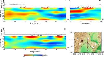
五大连池火山带位于大兴安岭、小兴安岭与松辽盆地的交界处。研究五大连池火山带地壳速度结构的细节,对更好地认识东北亚深部地球动力学具有重要意义。利用直接面波层析成像方法对2015年至2019年新部署的密集WAVESArray台站的环境噪声记录进行分析,建立了五大连池火山带及周边地区45 km深度地壳和上地幔的高分辨率三维s波速度(v)模型。WAVESArray台站在五大连池火山周围有良好的方位覆盖。我们的高分辨率层析模型揭示了五大池火山下地壳和上地幔的低vs异常以及中、下地壳的高vs异常,表明存在热地幔上涌和下地壳冷却凝固。这一上升流过程与俯冲太平洋板块上发育的大地幔楔的复杂动力学有关,该板块处于东亚地幔过渡带的停滞状态。此外,在上地壳的二克山、五大池、克罗、逊克火山下方可见低v异常,并与中下地壳的低v层相连接,为这些火山的同源性提供了新的地震学证据,表明这些火山之间可能存在物质和能量的交换。本文章由计算机程序翻译,如有差异,请以英文原文为准。
Crust and uppermost mantle S-wave velocity structure of the Wudalianchi volcanic belt from direct surface-wave tomography
The Wudalianchi volcanic belt is located at the junction among the Greater Xing’an range, the Lesser Xing’an range, and the Songliao basin. Investigation of detailed crustal velocity structure under the Wudalianchi volcanic belt is of great significance to better understand the deep geodynamics of Northeast Asia. Applying the direct surface-wave tomography method to ambient noise records of our newly deployed dense WAVESArray stations from 2015 to 2019, we aim to determine a high-resolution three-dimensional (3-D) S-wave velocity (Vs) model of the crust and uppermost mantle down to 45 km depth beneath the Wudalianchi volcanic belt and surrounding areas. The WAVESArray stations have good azimuthal coverage around the Wudalianchi volcano. Our high-resolution tomographic model reveals low-Vs anomalies in the upper crust and the uppermost mantle beneath the Wudalianchi volcano and high-Vs anomalies in the mid-lower crust, indicating the presence of hot mantle upwelling and lower crust cooling solidification. This upwelling process is related to the complex dynamics of the big mantle wedge that has developed above the subducted Pacific slab that is stagnant in the mantle transition zone beneath East Asia. In addition, low-Vs anomalies are visible beneath the Erkeshan, Wudalianchi, Keluo, and Xunke volcanoes in the upper crust and they are connected with a low-Vs layer in the mid-lower crust, which provides a new piece of seismological evidence for the homology of these volcanoes, suggesting that there might be exchanges of material and energy between these volcanoes.
求助全文
通过发布文献求助,成功后即可免费获取论文全文。
去求助
来源期刊
Journal of Asian Earth Sciences
地学-地球科学综合
CiteScore
5.90
自引率
10.00%
发文量
324
审稿时长
71 days
期刊介绍:
Journal of Asian Earth Sciences has an open access mirror journal Journal of Asian Earth Sciences: X, sharing the same aims and scope, editorial team, submission system and rigorous peer review.
The Journal of Asian Earth Sciences is an international interdisciplinary journal devoted to all aspects of research related to the solid Earth Sciences of Asia. The Journal publishes high quality, peer-reviewed scientific papers on the regional geology, tectonics, geochemistry and geophysics of Asia. It will be devoted primarily to research papers but short communications relating to new developments of broad interest, reviews and book reviews will also be included. Papers must have international appeal and should present work of more than local significance.
The scope includes deep processes of the Asian continent and its adjacent oceans; seismology and earthquakes; orogeny, magmatism, metamorphism and volcanism; growth, deformation and destruction of the Asian crust; crust-mantle interaction; evolution of life (early life, biostratigraphy, biogeography and mass-extinction); fluids, fluxes and reservoirs of mineral and energy resources; surface processes (weathering, erosion, transport and deposition of sediments) and resulting geomorphology; and the response of the Earth to global climate change as viewed within the Asian continent and surrounding oceans.
 求助内容:
求助内容: 应助结果提醒方式:


