Weibo Ma , Haidong Li , Shaogang Lei , Zhaomin Tong , Nannan Wang
{"title":"消除资源型城市矿区空间冲突和生态障碍的新型建模方法","authors":"Weibo Ma , Haidong Li , Shaogang Lei , Zhaomin Tong , Nannan Wang","doi":"10.1016/j.ecolind.2024.112858","DOIUrl":null,"url":null,"abstract":"<div><div>High-intensity coal mining damages land cover and ecosystems, causing land use spatial conflicts and blockage of ecological connectivity. The optimal allocation of land resource spatial layout is an effective way to alleviate land use conflicts and enhance ecological connectivity. This study designed a patch-level index for evaluating land use conflicts of “production-living-ecology” space and constructed a weighted roulette wheel mechanism to guide the biomimetic intelligent optimization model in improving the connectivity between the research area and surrounding ecosystems. A case study of typical urban mining areas showed that (1) the index can effectively characterize the spatial conflicts from complexity, vulnerability, and competitiveness and serve as an optimization objective to alleviate conflicts in land use allocation; (2) barrier spots and ecological pinch points were identified to provide a reference for the model in discovering potential areas that can be supplemented as ecological sources and corridors; (3) with only 0.7% grid adjustment, land use conflict was reduced by 4.9% and all other objectives were improved. Findings provide theoretical and methodological framework supports for characterizing and optimizing the spatial conflicts and ecological connectivity in resource-based cities, which can guide the sustainability of urban development, resource exploitation, and ecosystem protection.</div></div>","PeriodicalId":11459,"journal":{"name":"Ecological Indicators","volume":"169 ","pages":"Article 112858"},"PeriodicalIF":7.0000,"publicationDate":"2024-11-22","publicationTypes":"Journal Article","fieldsOfStudy":null,"isOpenAccess":false,"openAccessPdf":"","citationCount":"0","resultStr":"{\"title\":\"A novelty modeling approach to eliminate spatial conflicts and ecological barriers in mining areas of a resource-based city\",\"authors\":\"Weibo Ma , Haidong Li , Shaogang Lei , Zhaomin Tong , Nannan Wang\",\"doi\":\"10.1016/j.ecolind.2024.112858\",\"DOIUrl\":null,\"url\":null,\"abstract\":\"<div><div>High-intensity coal mining damages land cover and ecosystems, causing land use spatial conflicts and blockage of ecological connectivity. The optimal allocation of land resource spatial layout is an effective way to alleviate land use conflicts and enhance ecological connectivity. This study designed a patch-level index for evaluating land use conflicts of “production-living-ecology” space and constructed a weighted roulette wheel mechanism to guide the biomimetic intelligent optimization model in improving the connectivity between the research area and surrounding ecosystems. A case study of typical urban mining areas showed that (1) the index can effectively characterize the spatial conflicts from complexity, vulnerability, and competitiveness and serve as an optimization objective to alleviate conflicts in land use allocation; (2) barrier spots and ecological pinch points were identified to provide a reference for the model in discovering potential areas that can be supplemented as ecological sources and corridors; (3) with only 0.7% grid adjustment, land use conflict was reduced by 4.9% and all other objectives were improved. Findings provide theoretical and methodological framework supports for characterizing and optimizing the spatial conflicts and ecological connectivity in resource-based cities, which can guide the sustainability of urban development, resource exploitation, and ecosystem protection.</div></div>\",\"PeriodicalId\":11459,\"journal\":{\"name\":\"Ecological Indicators\",\"volume\":\"169 \",\"pages\":\"Article 112858\"},\"PeriodicalIF\":7.0000,\"publicationDate\":\"2024-11-22\",\"publicationTypes\":\"Journal Article\",\"fieldsOfStudy\":null,\"isOpenAccess\":false,\"openAccessPdf\":\"\",\"citationCount\":\"0\",\"resultStr\":null,\"platform\":\"Semanticscholar\",\"paperid\":null,\"PeriodicalName\":\"Ecological Indicators\",\"FirstCategoryId\":\"93\",\"ListUrlMain\":\"https://www.sciencedirect.com/science/article/pii/S1470160X24013153\",\"RegionNum\":2,\"RegionCategory\":\"环境科学与生态学\",\"ArticlePicture\":[],\"TitleCN\":null,\"AbstractTextCN\":null,\"PMCID\":null,\"EPubDate\":\"\",\"PubModel\":\"\",\"JCR\":\"Q1\",\"JCRName\":\"ENVIRONMENTAL SCIENCES\",\"Score\":null,\"Total\":0}","platform":"Semanticscholar","paperid":null,"PeriodicalName":"Ecological Indicators","FirstCategoryId":"93","ListUrlMain":"https://www.sciencedirect.com/science/article/pii/S1470160X24013153","RegionNum":2,"RegionCategory":"环境科学与生态学","ArticlePicture":[],"TitleCN":null,"AbstractTextCN":null,"PMCID":null,"EPubDate":"","PubModel":"","JCR":"Q1","JCRName":"ENVIRONMENTAL SCIENCES","Score":null,"Total":0}
A novelty modeling approach to eliminate spatial conflicts and ecological barriers in mining areas of a resource-based city
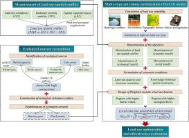
High-intensity coal mining damages land cover and ecosystems, causing land use spatial conflicts and blockage of ecological connectivity. The optimal allocation of land resource spatial layout is an effective way to alleviate land use conflicts and enhance ecological connectivity. This study designed a patch-level index for evaluating land use conflicts of “production-living-ecology” space and constructed a weighted roulette wheel mechanism to guide the biomimetic intelligent optimization model in improving the connectivity between the research area and surrounding ecosystems. A case study of typical urban mining areas showed that (1) the index can effectively characterize the spatial conflicts from complexity, vulnerability, and competitiveness and serve as an optimization objective to alleviate conflicts in land use allocation; (2) barrier spots and ecological pinch points were identified to provide a reference for the model in discovering potential areas that can be supplemented as ecological sources and corridors; (3) with only 0.7% grid adjustment, land use conflict was reduced by 4.9% and all other objectives were improved. Findings provide theoretical and methodological framework supports for characterizing and optimizing the spatial conflicts and ecological connectivity in resource-based cities, which can guide the sustainability of urban development, resource exploitation, and ecosystem protection.
期刊介绍:
The ultimate aim of Ecological Indicators is to integrate the monitoring and assessment of ecological and environmental indicators with management practices. The journal provides a forum for the discussion of the applied scientific development and review of traditional indicator approaches as well as for theoretical, modelling and quantitative applications such as index development. Research into the following areas will be published.
• All aspects of ecological and environmental indicators and indices.
• New indicators, and new approaches and methods for indicator development, testing and use.
• Development and modelling of indices, e.g. application of indicator suites across multiple scales and resources.
• Analysis and research of resource, system- and scale-specific indicators.
• Methods for integration of social and other valuation metrics for the production of scientifically rigorous and politically-relevant assessments using indicator-based monitoring and assessment programs.
• How research indicators can be transformed into direct application for management purposes.
• Broader assessment objectives and methods, e.g. biodiversity, biological integrity, and sustainability, through the use of indicators.
• Resource-specific indicators such as landscape, agroecosystems, forests, wetlands, etc.