{"title":"控制越南南部后河地区土地沉降的因素","authors":"Quoc-Cuong Tran , Thanh-Tam Vu , Okke Batelaan , Quy-Nhan Pham","doi":"10.1016/j.gsd.2024.101383","DOIUrl":null,"url":null,"abstract":"<div><div>The Vietnam's Mekong Delta (VMD) is known to be sinking below the sea due to climate change induced seawater level rise on one hand and land subsidence on the other hand. This phenomenon has deleterious ramifications for sustainable socio-economic advancement, manifesting in infrastructure degradation, recurrent inundation, intrusion of saline water, and reduction of habitable and cultivable areas within the region. Notably, in locales such as the Southern Hau River Region (SHRR), land subsidence rates as high as −10 cm/year have been documented, primarily associated with excessive groundwater extraction. Previous investigations have corroborated this relationship through the congruence between groundwater drawdown cones and areas of subsidence detected via InSAR (Interferometric Synthetic Aperture Radar) or through coupled Terzaghi consolidation theory-groundwater flow numerical modeling. This study extends the understanding of subsidence drivers in the SHRR beyond the groundwater level declining, encompassing tectonic activity, geological - lithological features, and landuse. Utilizing geostatistical analyses based on individual InSAR monitoring points, the study evaluates the respective contributions of these factors to land subsidence in the SHRR. Findings indicate that auto-compaction of young sediments, structural loading, and sediment compaction due to induced groundwater level decline are the principal factors precipitating land subsidence in the SHRR.</div></div>","PeriodicalId":37879,"journal":{"name":"Groundwater for Sustainable Development","volume":"27 ","pages":"Article 101383"},"PeriodicalIF":4.9000,"publicationDate":"2024-11-01","publicationTypes":"Journal Article","fieldsOfStudy":null,"isOpenAccess":false,"openAccessPdf":"","citationCount":"0","resultStr":"{\"title\":\"Factors controlling land subsidence in the Southern Hau River Region, Vietnam\",\"authors\":\"Quoc-Cuong Tran , Thanh-Tam Vu , Okke Batelaan , Quy-Nhan Pham\",\"doi\":\"10.1016/j.gsd.2024.101383\",\"DOIUrl\":null,\"url\":null,\"abstract\":\"<div><div>The Vietnam's Mekong Delta (VMD) is known to be sinking below the sea due to climate change induced seawater level rise on one hand and land subsidence on the other hand. This phenomenon has deleterious ramifications for sustainable socio-economic advancement, manifesting in infrastructure degradation, recurrent inundation, intrusion of saline water, and reduction of habitable and cultivable areas within the region. Notably, in locales such as the Southern Hau River Region (SHRR), land subsidence rates as high as −10 cm/year have been documented, primarily associated with excessive groundwater extraction. Previous investigations have corroborated this relationship through the congruence between groundwater drawdown cones and areas of subsidence detected via InSAR (Interferometric Synthetic Aperture Radar) or through coupled Terzaghi consolidation theory-groundwater flow numerical modeling. This study extends the understanding of subsidence drivers in the SHRR beyond the groundwater level declining, encompassing tectonic activity, geological - lithological features, and landuse. Utilizing geostatistical analyses based on individual InSAR monitoring points, the study evaluates the respective contributions of these factors to land subsidence in the SHRR. Findings indicate that auto-compaction of young sediments, structural loading, and sediment compaction due to induced groundwater level decline are the principal factors precipitating land subsidence in the SHRR.</div></div>\",\"PeriodicalId\":37879,\"journal\":{\"name\":\"Groundwater for Sustainable Development\",\"volume\":\"27 \",\"pages\":\"Article 101383\"},\"PeriodicalIF\":4.9000,\"publicationDate\":\"2024-11-01\",\"publicationTypes\":\"Journal Article\",\"fieldsOfStudy\":null,\"isOpenAccess\":false,\"openAccessPdf\":\"\",\"citationCount\":\"0\",\"resultStr\":null,\"platform\":\"Semanticscholar\",\"paperid\":null,\"PeriodicalName\":\"Groundwater for Sustainable Development\",\"FirstCategoryId\":\"1085\",\"ListUrlMain\":\"https://www.sciencedirect.com/science/article/pii/S2352801X24003060\",\"RegionNum\":0,\"RegionCategory\":null,\"ArticlePicture\":[],\"TitleCN\":null,\"AbstractTextCN\":null,\"PMCID\":null,\"EPubDate\":\"\",\"PubModel\":\"\",\"JCR\":\"Q2\",\"JCRName\":\"ENGINEERING, ENVIRONMENTAL\",\"Score\":null,\"Total\":0}","platform":"Semanticscholar","paperid":null,"PeriodicalName":"Groundwater for Sustainable Development","FirstCategoryId":"1085","ListUrlMain":"https://www.sciencedirect.com/science/article/pii/S2352801X24003060","RegionNum":0,"RegionCategory":null,"ArticlePicture":[],"TitleCN":null,"AbstractTextCN":null,"PMCID":null,"EPubDate":"","PubModel":"","JCR":"Q2","JCRName":"ENGINEERING, ENVIRONMENTAL","Score":null,"Total":0}
引用次数: 0
摘要
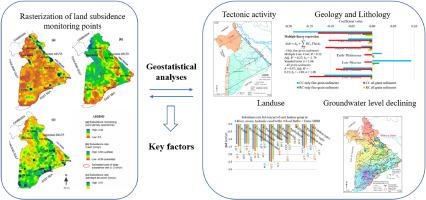
众所周知,越南湄公河三角洲(VMD)正在向海平面下沉,一方面是由于气候变化导致海水水位上升,另一方面是由于土地沉降。这一现象对社会经济的可持续发展产生了有害影响,表现为基础设施退化、经常性淹没、盐水入侵以及该地区可居住和可耕种面积减少。值得注意的是,在南口河地区(South Hau River Region,SHR)等地,记录的土地下沉率高达-10 厘米/年,这主要与过度抽取地下水有关。之前的研究通过 InSAR(干涉合成孔径雷达)或特尔扎吉固结理论-地下水流数值模型耦合检测到的地下水缩减锥与沉降区域之间的一致性证实了这种关系。这项研究将人们对下沉驱动因素的理解扩展到了地下水位下降之外,包括构造活动、地质-岩性特征和土地利用。该研究利用基于单个 InSAR 监测点的地质统计分析,评估了这些因素各自对下沉径流区土地沉降的影响。研究结果表明,年轻沉积物的自动压实、结构荷载以及诱发地下水位下降导致的沉积物压实是造成下拉河谷土地沉降的主要因素。
Factors controlling land subsidence in the Southern Hau River Region, Vietnam
The Vietnam's Mekong Delta (VMD) is known to be sinking below the sea due to climate change induced seawater level rise on one hand and land subsidence on the other hand. This phenomenon has deleterious ramifications for sustainable socio-economic advancement, manifesting in infrastructure degradation, recurrent inundation, intrusion of saline water, and reduction of habitable and cultivable areas within the region. Notably, in locales such as the Southern Hau River Region (SHRR), land subsidence rates as high as −10 cm/year have been documented, primarily associated with excessive groundwater extraction. Previous investigations have corroborated this relationship through the congruence between groundwater drawdown cones and areas of subsidence detected via InSAR (Interferometric Synthetic Aperture Radar) or through coupled Terzaghi consolidation theory-groundwater flow numerical modeling. This study extends the understanding of subsidence drivers in the SHRR beyond the groundwater level declining, encompassing tectonic activity, geological - lithological features, and landuse. Utilizing geostatistical analyses based on individual InSAR monitoring points, the study evaluates the respective contributions of these factors to land subsidence in the SHRR. Findings indicate that auto-compaction of young sediments, structural loading, and sediment compaction due to induced groundwater level decline are the principal factors precipitating land subsidence in the SHRR.
期刊介绍:
Groundwater for Sustainable Development is directed to different stakeholders and professionals, including government and non-governmental organizations, international funding agencies, universities, public water institutions, public health and other public/private sector professionals, and other relevant institutions. It is aimed at professionals, academics and students in the fields of disciplines such as: groundwater and its connection to surface hydrology and environment, soil sciences, engineering, ecology, microbiology, atmospheric sciences, analytical chemistry, hydro-engineering, water technology, environmental ethics, economics, public health, policy, as well as social sciences, legal disciplines, or any other area connected with water issues. The objectives of this journal are to facilitate: • The improvement of effective and sustainable management of water resources across the globe. • The improvement of human access to groundwater resources in adequate quantity and good quality. • The meeting of the increasing demand for drinking and irrigation water needed for food security to contribute to a social and economically sound human development. • The creation of a global inter- and multidisciplinary platform and forum to improve our understanding of groundwater resources and to advocate their effective and sustainable management and protection against contamination. • Interdisciplinary information exchange and to stimulate scientific research in the fields of groundwater related sciences and social and health sciences required to achieve the United Nations Millennium Development Goals for sustainable development.