利用机器学习方法绘制印度尼西亚西爪哇的地下水潜力图

IF 4.9 Q2 ENGINEERING, ENVIRONMENTAL
Jalu Tejo Nugroho , Anugrah Indah Lestari , Budhi Gustiandi , Parwati Sofan , Suwarsono , Indah Prasasti , Khalifah Insan Nur Rahmi , Heru Noviar , Nurwita Mustika Sari , R. Johannes Manalu , Samsul Arifin , Ahmad Taufiq
{"title":"利用机器学习方法绘制印度尼西亚西爪哇的地下水潜力图","authors":"Jalu Tejo Nugroho ,&nbsp;Anugrah Indah Lestari ,&nbsp;Budhi Gustiandi ,&nbsp;Parwati Sofan ,&nbsp;Suwarsono ,&nbsp;Indah Prasasti ,&nbsp;Khalifah Insan Nur Rahmi ,&nbsp;Heru Noviar ,&nbsp;Nurwita Mustika Sari ,&nbsp;R. Johannes Manalu ,&nbsp;Samsul Arifin ,&nbsp;Ahmad Taufiq","doi":"10.1016/j.gsd.2024.101382","DOIUrl":null,"url":null,"abstract":"<div><div>Groundwater availability is a challenge as it is utilized for vital sectors such as agricultural sector, human consumption, and industrial sector. Therefore, water resource mapping is needed to be performed to maintain water resource sustainability. This research aims to investigate groundwater potential in West Java, Indonesia using supervised machine learning (ML) methods namely Random Forest (RF), Support Vector Machine (SVM), and Artificial Neural Network (ANN). Several groundwater conditioning factors were used in this research such as Topographic Wetness Index (TWI), Normalized Difference Vegetation Index (NDVI), lithology, geomorphology, land use land cover (LULC), soil type, and land system. The groundwater potential prediction model was validated using the groundwater potential map and well locations obtained from the Ministry of Energy and Mineral Resources and the Ministry of Public Works and Public Housing of Republic of Indonesia, respectively. The results show that the highest overall accuracy was achieved using RF method (0.8). We found that the land system was the highest contributor to groundwater potential mapping (25%), followed by lithology (16%), NDVI (15%), geomorphology and TWI (14% each), and LULC and soil type (8% each). More than 50% of the West Java Province region exhibited groundwater potential in very low and low classes, while the high and very high classes of groundwater potential were only less than 16%. Ground geoelectric measurements were conducted in sample areas in Bandung City and Sukabumi District, representing very high and very low groundwater potentials, respectively. This study emphasizes the critical need to implement measures that ensure the sustainability of water resources and prevent mismanagement of groundwater extraction, particularly in West Java.</div></div>","PeriodicalId":37879,"journal":{"name":"Groundwater for Sustainable Development","volume":"27 ","pages":"Article 101382"},"PeriodicalIF":4.9000,"publicationDate":"2024-11-01","publicationTypes":"Journal Article","fieldsOfStudy":null,"isOpenAccess":false,"openAccessPdf":"","citationCount":"0","resultStr":"{\"title\":\"Groundwater potential mapping using machine learning approach in West Java, Indonesia\",\"authors\":\"Jalu Tejo Nugroho ,&nbsp;Anugrah Indah Lestari ,&nbsp;Budhi Gustiandi ,&nbsp;Parwati Sofan ,&nbsp;Suwarsono ,&nbsp;Indah Prasasti ,&nbsp;Khalifah Insan Nur Rahmi ,&nbsp;Heru Noviar ,&nbsp;Nurwita Mustika Sari ,&nbsp;R. Johannes Manalu ,&nbsp;Samsul Arifin ,&nbsp;Ahmad Taufiq\",\"doi\":\"10.1016/j.gsd.2024.101382\",\"DOIUrl\":null,\"url\":null,\"abstract\":\"<div><div>Groundwater availability is a challenge as it is utilized for vital sectors such as agricultural sector, human consumption, and industrial sector. Therefore, water resource mapping is needed to be performed to maintain water resource sustainability. This research aims to investigate groundwater potential in West Java, Indonesia using supervised machine learning (ML) methods namely Random Forest (RF), Support Vector Machine (SVM), and Artificial Neural Network (ANN). Several groundwater conditioning factors were used in this research such as Topographic Wetness Index (TWI), Normalized Difference Vegetation Index (NDVI), lithology, geomorphology, land use land cover (LULC), soil type, and land system. The groundwater potential prediction model was validated using the groundwater potential map and well locations obtained from the Ministry of Energy and Mineral Resources and the Ministry of Public Works and Public Housing of Republic of Indonesia, respectively. The results show that the highest overall accuracy was achieved using RF method (0.8). We found that the land system was the highest contributor to groundwater potential mapping (25%), followed by lithology (16%), NDVI (15%), geomorphology and TWI (14% each), and LULC and soil type (8% each). More than 50% of the West Java Province region exhibited groundwater potential in very low and low classes, while the high and very high classes of groundwater potential were only less than 16%. Ground geoelectric measurements were conducted in sample areas in Bandung City and Sukabumi District, representing very high and very low groundwater potentials, respectively. This study emphasizes the critical need to implement measures that ensure the sustainability of water resources and prevent mismanagement of groundwater extraction, particularly in West Java.</div></div>\",\"PeriodicalId\":37879,\"journal\":{\"name\":\"Groundwater for Sustainable Development\",\"volume\":\"27 \",\"pages\":\"Article 101382\"},\"PeriodicalIF\":4.9000,\"publicationDate\":\"2024-11-01\",\"publicationTypes\":\"Journal Article\",\"fieldsOfStudy\":null,\"isOpenAccess\":false,\"openAccessPdf\":\"\",\"citationCount\":\"0\",\"resultStr\":null,\"platform\":\"Semanticscholar\",\"paperid\":null,\"PeriodicalName\":\"Groundwater for Sustainable Development\",\"FirstCategoryId\":\"1085\",\"ListUrlMain\":\"https://www.sciencedirect.com/science/article/pii/S2352801X24003059\",\"RegionNum\":0,\"RegionCategory\":null,\"ArticlePicture\":[],\"TitleCN\":null,\"AbstractTextCN\":null,\"PMCID\":null,\"EPubDate\":\"\",\"PubModel\":\"\",\"JCR\":\"Q2\",\"JCRName\":\"ENGINEERING, ENVIRONMENTAL\",\"Score\":null,\"Total\":0}","platform":"Semanticscholar","paperid":null,"PeriodicalName":"Groundwater for Sustainable Development","FirstCategoryId":"1085","ListUrlMain":"https://www.sciencedirect.com/science/article/pii/S2352801X24003059","RegionNum":0,"RegionCategory":null,"ArticlePicture":[],"TitleCN":null,"AbstractTextCN":null,"PMCID":null,"EPubDate":"","PubModel":"","JCR":"Q2","JCRName":"ENGINEERING, ENVIRONMENTAL","Score":null,"Total":0}
引用次数: 0

摘要

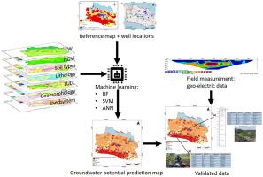
地下水供应是一项挑战,因为它被用于农业部门、人类消费和工业部门等重要部门。因此,需要绘制水资源图,以保持水资源的可持续性。本研究旨在使用有监督的机器学习(ML)方法,即随机森林(RF)、支持向量机(SVM)和人工神经网络(ANN),调查印度尼西亚西爪哇的地下水潜力。本研究使用了多个地下水条件因子,如地形湿润指数(TWI)、归一化植被指数(NDVI)、岩性、地貌、土地利用土地覆盖(LULC)、土壤类型和土地系统。利用分别从印度尼西亚共和国能源和矿产资源部以及公共工程和公共住房部获得的地下水潜势图和水井位置,对地下水潜势预测模型进行了验证。结果表明,射频法的总体精度最高(0.8)。我们发现,土地系统对地下水潜势绘图的贡献率最高(25%),其次是岩性(16%)、NDVI(15%)、地貌和 TWI(各 14%)以及 LULC 和土壤类型(各 8%)。西爪哇省 50%以上地区的地下水潜势为极低和低级别,而地下水潜势为高和极高级别的地区仅占不到 16%。在万隆市和苏卡布米地区的样本区域进行了地面地电测量,这两个地区分别代表了极高和极低的地下水潜力。这项研究强调,亟需采取措施确保水资源的可持续性,防止地下水开采管理不善,尤其是在西爪哇。
本文章由计算机程序翻译,如有差异,请以英文原文为准。

Groundwater potential mapping using machine learning approach in West Java, Indonesia

Groundwater potential mapping using machine learning approach in West Java, Indonesia
Groundwater availability is a challenge as it is utilized for vital sectors such as agricultural sector, human consumption, and industrial sector. Therefore, water resource mapping is needed to be performed to maintain water resource sustainability. This research aims to investigate groundwater potential in West Java, Indonesia using supervised machine learning (ML) methods namely Random Forest (RF), Support Vector Machine (SVM), and Artificial Neural Network (ANN). Several groundwater conditioning factors were used in this research such as Topographic Wetness Index (TWI), Normalized Difference Vegetation Index (NDVI), lithology, geomorphology, land use land cover (LULC), soil type, and land system. The groundwater potential prediction model was validated using the groundwater potential map and well locations obtained from the Ministry of Energy and Mineral Resources and the Ministry of Public Works and Public Housing of Republic of Indonesia, respectively. The results show that the highest overall accuracy was achieved using RF method (0.8). We found that the land system was the highest contributor to groundwater potential mapping (25%), followed by lithology (16%), NDVI (15%), geomorphology and TWI (14% each), and LULC and soil type (8% each). More than 50% of the West Java Province region exhibited groundwater potential in very low and low classes, while the high and very high classes of groundwater potential were only less than 16%. Ground geoelectric measurements were conducted in sample areas in Bandung City and Sukabumi District, representing very high and very low groundwater potentials, respectively. This study emphasizes the critical need to implement measures that ensure the sustainability of water resources and prevent mismanagement of groundwater extraction, particularly in West Java.
求助全文
通过发布文献求助,成功后即可免费获取论文全文。 去求助
来源期刊
Groundwater for Sustainable Development
Groundwater for Sustainable Development Social Sciences-Geography, Planning and Development
CiteScore
11.50
自引率
10.20%
发文量
152
期刊介绍: Groundwater for Sustainable Development is directed to different stakeholders and professionals, including government and non-governmental organizations, international funding agencies, universities, public water institutions, public health and other public/private sector professionals, and other relevant institutions. It is aimed at professionals, academics and students in the fields of disciplines such as: groundwater and its connection to surface hydrology and environment, soil sciences, engineering, ecology, microbiology, atmospheric sciences, analytical chemistry, hydro-engineering, water technology, environmental ethics, economics, public health, policy, as well as social sciences, legal disciplines, or any other area connected with water issues. The objectives of this journal are to facilitate: • The improvement of effective and sustainable management of water resources across the globe. • The improvement of human access to groundwater resources in adequate quantity and good quality. • The meeting of the increasing demand for drinking and irrigation water needed for food security to contribute to a social and economically sound human development. • The creation of a global inter- and multidisciplinary platform and forum to improve our understanding of groundwater resources and to advocate their effective and sustainable management and protection against contamination. • Interdisciplinary information exchange and to stimulate scientific research in the fields of groundwater related sciences and social and health sciences required to achieve the United Nations Millennium Development Goals for sustainable development.
×
引用
GB/T 7714-2015
复制
MLA
复制
APA
复制
导出至
BibTeX EndNote RefMan NoteFirst NoteExpress
×
提示
您的信息不完整,为了账户安全,请先补充。
现在去补充
×
提示
您因"违规操作"
具体请查看互助需知
我知道了
×
提示
确定
请完成安全验证×
copy
已复制链接
快去分享给好友吧!
我知道了
右上角分享
点击右上角分享
0
联系我们:info@booksci.cn Book学术提供免费学术资源搜索服务,方便国内外学者检索中英文文献。致力于提供最便捷和优质的服务体验。 Copyright © 2023 布克学术 All rights reserved.
京ICP备2023020795号-1
ghs 京公网安备 11010802042870号
Book学术文献互助
Book学术文献互助群
群 号:481959085
Book学术官方微信