{"title":"通过综合灾害和脆弱性指数评估孟加拉国东南部的山体滑坡风险","authors":"Neegar Sultana , Shukui Tan , Md. Farhad Hossen","doi":"10.1016/j.ijdrr.2024.104991","DOIUrl":null,"url":null,"abstract":"<div><div>Landslide risk assessment (LRA) is crucial to develop sustainable risk reduction and response measures. Although Southeast Bangladesh is prone to landslides, there is insufficient comprehensive investigation that incorporates susceptibility and vulnerability assessments with LRA. This study first calculated the Landslide Susceptibility Index (LSI) using the frequency ratio (FR), verified it using the ROC-AUC curve, and then measured the Social Vulnerability Index (SoVI) using Principal Component Analysis (PCA). Finally, the research integrated the LSI and SoVI map by normalizing and weighting to compute a Landslide Risk Index (LRI) map. The region's LSI reveals 10.19 % very high, 28.10 % moderate, and 13.41 % very low landslide susceptibility. According to the FR model, slope, elevation NDVI, and rainfall predispose to landslides. However, the SoVI revealed 39.3 % of Upazilas experienced medium landslide social vulnerability, which is hazard independent. The LRI statistics classify landslide risk as very high (23 %), high (12 %), moderate (28 %), low (20 %), or very low (17 %) for a total area of 19163.53 km<sup>2</sup>. A district-wise risk analysis ranks landslide risk as Chattogram > Cox's Bazar > Rangamati > Khagrachhari > Bandarban due to short-term or prolonged rainfall, natural drainage changes, unplanned development, deforestation, hydroelectric plant effects, and population growth. The landslide risk is highest in Teknaf, Ukhia, and Ramu Upazilas and lowest in Thanchi, Rowangchhari, Juraichhari, and Langadu. LSI performed satisfactorily with an AUC-based prediction rate of 81.8 % and success rate curve of 87.0 %. Finally, decision-makers can implement this macro-scale regional landslide risk analysis for southeast hilly Bangladesh for developing sustainable risk reduction schemes.</div></div>","PeriodicalId":13915,"journal":{"name":"International journal of disaster risk reduction","volume":"114 ","pages":"Article 104991"},"PeriodicalIF":4.2000,"publicationDate":"2024-11-01","publicationTypes":"Journal Article","fieldsOfStudy":null,"isOpenAccess":false,"openAccessPdf":"","citationCount":"0","resultStr":"{\"title\":\"Landslide risk assessment by integrating hazards and vulnerability indices in Southeast Bangladesh\",\"authors\":\"Neegar Sultana , Shukui Tan , Md. Farhad Hossen\",\"doi\":\"10.1016/j.ijdrr.2024.104991\",\"DOIUrl\":null,\"url\":null,\"abstract\":\"<div><div>Landslide risk assessment (LRA) is crucial to develop sustainable risk reduction and response measures. Although Southeast Bangladesh is prone to landslides, there is insufficient comprehensive investigation that incorporates susceptibility and vulnerability assessments with LRA. This study first calculated the Landslide Susceptibility Index (LSI) using the frequency ratio (FR), verified it using the ROC-AUC curve, and then measured the Social Vulnerability Index (SoVI) using Principal Component Analysis (PCA). Finally, the research integrated the LSI and SoVI map by normalizing and weighting to compute a Landslide Risk Index (LRI) map. The region's LSI reveals 10.19 % very high, 28.10 % moderate, and 13.41 % very low landslide susceptibility. According to the FR model, slope, elevation NDVI, and rainfall predispose to landslides. However, the SoVI revealed 39.3 % of Upazilas experienced medium landslide social vulnerability, which is hazard independent. The LRI statistics classify landslide risk as very high (23 %), high (12 %), moderate (28 %), low (20 %), or very low (17 %) for a total area of 19163.53 km<sup>2</sup>. A district-wise risk analysis ranks landslide risk as Chattogram > Cox's Bazar > Rangamati > Khagrachhari > Bandarban due to short-term or prolonged rainfall, natural drainage changes, unplanned development, deforestation, hydroelectric plant effects, and population growth. The landslide risk is highest in Teknaf, Ukhia, and Ramu Upazilas and lowest in Thanchi, Rowangchhari, Juraichhari, and Langadu. LSI performed satisfactorily with an AUC-based prediction rate of 81.8 % and success rate curve of 87.0 %. Finally, decision-makers can implement this macro-scale regional landslide risk analysis for southeast hilly Bangladesh for developing sustainable risk reduction schemes.</div></div>\",\"PeriodicalId\":13915,\"journal\":{\"name\":\"International journal of disaster risk reduction\",\"volume\":\"114 \",\"pages\":\"Article 104991\"},\"PeriodicalIF\":4.2000,\"publicationDate\":\"2024-11-01\",\"publicationTypes\":\"Journal Article\",\"fieldsOfStudy\":null,\"isOpenAccess\":false,\"openAccessPdf\":\"\",\"citationCount\":\"0\",\"resultStr\":null,\"platform\":\"Semanticscholar\",\"paperid\":null,\"PeriodicalName\":\"International journal of disaster risk reduction\",\"FirstCategoryId\":\"89\",\"ListUrlMain\":\"https://www.sciencedirect.com/science/article/pii/S2212420924007532\",\"RegionNum\":1,\"RegionCategory\":\"地球科学\",\"ArticlePicture\":[],\"TitleCN\":null,\"AbstractTextCN\":null,\"PMCID\":null,\"EPubDate\":\"\",\"PubModel\":\"\",\"JCR\":\"Q1\",\"JCRName\":\"GEOSCIENCES, MULTIDISCIPLINARY\",\"Score\":null,\"Total\":0}","platform":"Semanticscholar","paperid":null,"PeriodicalName":"International journal of disaster risk reduction","FirstCategoryId":"89","ListUrlMain":"https://www.sciencedirect.com/science/article/pii/S2212420924007532","RegionNum":1,"RegionCategory":"地球科学","ArticlePicture":[],"TitleCN":null,"AbstractTextCN":null,"PMCID":null,"EPubDate":"","PubModel":"","JCR":"Q1","JCRName":"GEOSCIENCES, MULTIDISCIPLINARY","Score":null,"Total":0}
Landslide risk assessment by integrating hazards and vulnerability indices in Southeast Bangladesh
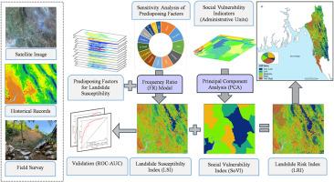
Landslide risk assessment (LRA) is crucial to develop sustainable risk reduction and response measures. Although Southeast Bangladesh is prone to landslides, there is insufficient comprehensive investigation that incorporates susceptibility and vulnerability assessments with LRA. This study first calculated the Landslide Susceptibility Index (LSI) using the frequency ratio (FR), verified it using the ROC-AUC curve, and then measured the Social Vulnerability Index (SoVI) using Principal Component Analysis (PCA). Finally, the research integrated the LSI and SoVI map by normalizing and weighting to compute a Landslide Risk Index (LRI) map. The region's LSI reveals 10.19 % very high, 28.10 % moderate, and 13.41 % very low landslide susceptibility. According to the FR model, slope, elevation NDVI, and rainfall predispose to landslides. However, the SoVI revealed 39.3 % of Upazilas experienced medium landslide social vulnerability, which is hazard independent. The LRI statistics classify landslide risk as very high (23 %), high (12 %), moderate (28 %), low (20 %), or very low (17 %) for a total area of 19163.53 km2. A district-wise risk analysis ranks landslide risk as Chattogram > Cox's Bazar > Rangamati > Khagrachhari > Bandarban due to short-term or prolonged rainfall, natural drainage changes, unplanned development, deforestation, hydroelectric plant effects, and population growth. The landslide risk is highest in Teknaf, Ukhia, and Ramu Upazilas and lowest in Thanchi, Rowangchhari, Juraichhari, and Langadu. LSI performed satisfactorily with an AUC-based prediction rate of 81.8 % and success rate curve of 87.0 %. Finally, decision-makers can implement this macro-scale regional landslide risk analysis for southeast hilly Bangladesh for developing sustainable risk reduction schemes.
期刊介绍:
The International Journal of Disaster Risk Reduction (IJDRR) is the journal for researchers, policymakers and practitioners across diverse disciplines: earth sciences and their implications; environmental sciences; engineering; urban studies; geography; and the social sciences. IJDRR publishes fundamental and applied research, critical reviews, policy papers and case studies with a particular focus on multi-disciplinary research that aims to reduce the impact of natural, technological, social and intentional disasters. IJDRR stimulates exchange of ideas and knowledge transfer on disaster research, mitigation, adaptation, prevention and risk reduction at all geographical scales: local, national and international.
Key topics:-
-multifaceted disaster and cascading disasters
-the development of disaster risk reduction strategies and techniques
-discussion and development of effective warning and educational systems for risk management at all levels
-disasters associated with climate change
-vulnerability analysis and vulnerability trends
-emerging risks
-resilience against disasters.
The journal particularly encourages papers that approach risk from a multi-disciplinary perspective.