泰国北部 Western Mae Chan 断层对活动构造的空间景观响应
IF 2.7
3区 地球科学
Q2 GEOSCIENCES, MULTIDISCIPLINARY
引用次数: 0
摘要
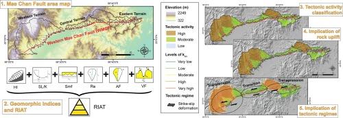
湄南断层(MCF)是泰国北部、老挝人民民主共和国和缅甸的活跃断层之一。尽管该断层十分活跃,但最近的地震记录显示,湄南断裂带的地震频率和震级均低于周边地区。形态构造分析根据排水系统的调整和地貌表现评估相对构造活动。我们分析了西部湄潭断层(WMCF),以探索地貌对相对岩石隆起和长期变形的空间响应。我们利用遥感技术划定了断层段线,并利用数字高程模型绘制了地形表现图。我们分析了沿西部断裂带发育的 70 条低阶河道的地形变化,并利用地貌指数对构造活动进行了评估,包括吸水率积分和吸水率曲线、标准化溪流长度-坡度指数、伸长比、流域不对称因子、山前凹度和谷底宽高比。将这些地貌因子与实地观测结果相结合,就可以得到活动构造相对指数(RIAT)。我们的研究结果表明,遥感技术的线状探测显示了断层段的ENE-WSW方向。总体构造活动相对温和,但西部地形和东部高地形沿线存在较高的构造活动。各种构造活动与线状密度和不同岩石隆起的空间变化相一致,地形在空间上经历了转位和换位制度的变化。这项研究凸显了西麦哲伦地峡沿线潜在的长期构造活动,这些构造活动主导了现代地貌的形成。本文章由计算机程序翻译,如有差异,请以英文原文为准。
Spatial landscape response to active tectonics along the Western Mae Chan Fault, Northern Thailand
Mae Chan Fault (MCF) is one of the active faults in northern Thailand, Lao PDR, and Myanmar. Despite fault activeness, the records of recent earthquakes show a lower frequency and magnitude of earthquakes across the MCF than those of the surrounding regions. The morphotectonic analysis evaluates relative tectonic activity based on the drainage systems’ adjustment and geomorphic expressions. We analyzed the Western Mae Chan Fault (WMCF) to explore the spatial response of landscape to relative rock uplift and long-term deformation. We delineated fault segment lines from the remote sensing and the topographic expressions from the digital elevation model. We analyzed the topographic variations from 70 low-order channels developed along the WMCF and evaluated the tectonic activity using geomorphic indices, including the hypsometric integral and hypsometric curve, the standardized stream length-gradient index, the elongation ratio, the drainage basin asymmetrical factor, the mountain front sinuosity, and the valley floor width-to-height ratio. Combining these geomorphic factors with field observations provides the relative indices of active tectonics (RIAT). Our findings revealed that lineament detection from the remote sensing technique indicated the ENE-WSW direction of fault segments. The overall tectonic activity is relatively moderate, but high tectonic activity is present along the western terrain and high topography in the east. The various tectonic activities are consistent with the spatial variations in lineament density and differential rock uplift, where the terrain experienced spatial variations in transtensional and transpressional regimes. This study highlights the potential long-term tectonic activity along the WMCF that dominantly sculpts the modern landscape.
求助全文
通过发布文献求助,成功后即可免费获取论文全文。
去求助
来源期刊
Journal of Asian Earth Sciences
地学-地球科学综合
CiteScore
5.90
自引率
10.00%
发文量
324
审稿时长
71 days
期刊介绍:
Journal of Asian Earth Sciences has an open access mirror journal Journal of Asian Earth Sciences: X, sharing the same aims and scope, editorial team, submission system and rigorous peer review.
The Journal of Asian Earth Sciences is an international interdisciplinary journal devoted to all aspects of research related to the solid Earth Sciences of Asia. The Journal publishes high quality, peer-reviewed scientific papers on the regional geology, tectonics, geochemistry and geophysics of Asia. It will be devoted primarily to research papers but short communications relating to new developments of broad interest, reviews and book reviews will also be included. Papers must have international appeal and should present work of more than local significance.
The scope includes deep processes of the Asian continent and its adjacent oceans; seismology and earthquakes; orogeny, magmatism, metamorphism and volcanism; growth, deformation and destruction of the Asian crust; crust-mantle interaction; evolution of life (early life, biostratigraphy, biogeography and mass-extinction); fluids, fluxes and reservoirs of mineral and energy resources; surface processes (weathering, erosion, transport and deposition of sediments) and resulting geomorphology; and the response of the Earth to global climate change as viewed within the Asian continent and surrounding oceans.
 求助内容:
求助内容: 应助结果提醒方式:


