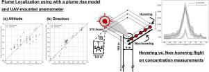
加强无螺旋桨飞行器技术以监测点源温室气体羽流

IF 4.2 2区 环境科学与生态学 Q2 ENVIRONMENTAL SCIENCES
Horim Kim , Keun Taek Kim , Sangjae Jeong , Young Su Lee , Xin Zhao , Jae Young Kim
{"title":"加强无螺旋桨飞行器技术以监测点源温室气体羽流","authors":"Horim Kim ,&nbsp;Keun Taek Kim ,&nbsp;Sangjae Jeong ,&nbsp;Young Su Lee ,&nbsp;Xin Zhao ,&nbsp;Jae Young Kim","doi":"10.1016/j.atmosenv.2024.120924","DOIUrl":null,"url":null,"abstract":"<div><div>The urgency of the global climate crisis necessitates advanced monitoring of greenhouse gases, with an emphasis on capturing their spatial and temporal variability. This study explores techniques to enhance plume detection and concentration measurements using uncrewed aerial vehicles (UAVs) for monitoring at point sources, specifically at an incineration stack. Through preliminary site investigations, our approach employed strategically designed flight paths and an autopilot system to optimize flight operations within the constraints of limited flight time due to battery capacity. We combined a UAV-mounted anemometer with a plume rise model to localize the plume center at a distance of 30 m from the stack center and evaluated its performance by comparing the model-based estimations at different altitudes and angular directions with the observation results. The comparison demonstrated that the results obtained by localizing the plume center using a plume rise model and a UAV-mounted anemometer aligned well with observations based on CO<sub>2</sub> concentration analysis. The comparative analysis showed a RMSE of 8.44 m and a MAE of 7.26 m for altitude, and a RMSE of 32.31<span><math><msup><mrow></mrow><mrow><mo>∘</mo></mrow></msup></math></span> and a MAE of 25.78<span><math><msup><mrow></mrow><mrow><mo>∘</mo></mrow></msup></math></span> for angular direction. Furthermore, we assessed the effectiveness of hovering UAV flights, in which a UAV remains stationary at a fixed point in the air, compared to non-hovering flights in capturing pollutant concentration. While both methods performed similarly in detecting the plume center, non-hovering flights underestimated the CO<sub>2</sub> concentration due to insufficient time for measurement despite a sensor response time of less than three seconds. Overall, our proposed hybrid monitoring strategy integrates non-hovering and hovering flights, enhancing both plume detection efficiency and concentration measurement accuracy at point sources.</div></div>","PeriodicalId":250,"journal":{"name":"Atmospheric Environment","volume":"342 ","pages":"Article 120924"},"PeriodicalIF":4.2000,"publicationDate":"2024-11-16","publicationTypes":"Journal Article","fieldsOfStudy":null,"isOpenAccess":false,"openAccessPdf":"","citationCount":"0","resultStr":"{\"title\":\"Enhancing Uncrewed Aerial Vehicle Techniques for Monitoring Greenhouse Gas Plumes at Point Sources\",\"authors\":\"Horim Kim ,&nbsp;Keun Taek Kim ,&nbsp;Sangjae Jeong ,&nbsp;Young Su Lee ,&nbsp;Xin Zhao ,&nbsp;Jae Young Kim\",\"doi\":\"10.1016/j.atmosenv.2024.120924\",\"DOIUrl\":null,\"url\":null,\"abstract\":\"<div><div>The urgency of the global climate crisis necessitates advanced monitoring of greenhouse gases, with an emphasis on capturing their spatial and temporal variability. This study explores techniques to enhance plume detection and concentration measurements using uncrewed aerial vehicles (UAVs) for monitoring at point sources, specifically at an incineration stack. Through preliminary site investigations, our approach employed strategically designed flight paths and an autopilot system to optimize flight operations within the constraints of limited flight time due to battery capacity. We combined a UAV-mounted anemometer with a plume rise model to localize the plume center at a distance of 30 m from the stack center and evaluated its performance by comparing the model-based estimations at different altitudes and angular directions with the observation results. The comparison demonstrated that the results obtained by localizing the plume center using a plume rise model and a UAV-mounted anemometer aligned well with observations based on CO<sub>2</sub> concentration analysis. The comparative analysis showed a RMSE of 8.44 m and a MAE of 7.26 m for altitude, and a RMSE of 32.31<span><math><msup><mrow></mrow><mrow><mo>∘</mo></mrow></msup></math></span> and a MAE of 25.78<span><math><msup><mrow></mrow><mrow><mo>∘</mo></mrow></msup></math></span> for angular direction. Furthermore, we assessed the effectiveness of hovering UAV flights, in which a UAV remains stationary at a fixed point in the air, compared to non-hovering flights in capturing pollutant concentration. While both methods performed similarly in detecting the plume center, non-hovering flights underestimated the CO<sub>2</sub> concentration due to insufficient time for measurement despite a sensor response time of less than three seconds. Overall, our proposed hybrid monitoring strategy integrates non-hovering and hovering flights, enhancing both plume detection efficiency and concentration measurement accuracy at point sources.</div></div>\",\"PeriodicalId\":250,\"journal\":{\"name\":\"Atmospheric Environment\",\"volume\":\"342 \",\"pages\":\"Article 120924\"},\"PeriodicalIF\":4.2000,\"publicationDate\":\"2024-11-16\",\"publicationTypes\":\"Journal Article\",\"fieldsOfStudy\":null,\"isOpenAccess\":false,\"openAccessPdf\":\"\",\"citationCount\":\"0\",\"resultStr\":null,\"platform\":\"Semanticscholar\",\"paperid\":null,\"PeriodicalName\":\"Atmospheric Environment\",\"FirstCategoryId\":\"93\",\"ListUrlMain\":\"https://www.sciencedirect.com/science/article/pii/S1352231024005995\",\"RegionNum\":2,\"RegionCategory\":\"环境科学与生态学\",\"ArticlePicture\":[],\"TitleCN\":null,\"AbstractTextCN\":null,\"PMCID\":null,\"EPubDate\":\"\",\"PubModel\":\"\",\"JCR\":\"Q2\",\"JCRName\":\"ENVIRONMENTAL SCIENCES\",\"Score\":null,\"Total\":0}","platform":"Semanticscholar","paperid":null,"PeriodicalName":"Atmospheric Environment","FirstCategoryId":"93","ListUrlMain":"https://www.sciencedirect.com/science/article/pii/S1352231024005995","RegionNum":2,"RegionCategory":"环境科学与生态学","ArticlePicture":[],"TitleCN":null,"AbstractTextCN":null,"PMCID":null,"EPubDate":"","PubModel":"","JCR":"Q2","JCRName":"ENVIRONMENTAL SCIENCES","Score":null,"Total":0}
引用次数: 0

摘要

全球气候危机的紧迫性要求对温室气体进行先进的监测,重点是捕捉其空间和时间变化。本研究探讨了利用无人驾驶飞行器(UAVs)加强羽流探测和浓度测量的技术,以监测点源,特别是焚烧烟囱。通过初步现场调查,我们的方法采用了战略性设计的飞行路径和自动驾驶系统,以便在电池容量导致飞行时间有限的限制条件下优化飞行操作。我们将无人飞行器安装的风速计与烟羽上升模型相结合,在距离烟囱中心 30 米处定位烟羽中心,并通过比较不同高度和角度方向上基于模型的估算结果与观测结果,对其性能进行评估。比较结果表明,使用烟羽上升模型和无人机安装的风速计定位烟羽中心所获得的结果与基于二氧化碳浓度分析的观测结果非常吻合。对比分析表明,高度的均方根误差为 8.44 米,最大误差为 7.26 米;角度方向的均方根误差为 32.31∘,最大误差为 25.78∘。此外,我们还评估了无人机悬停飞行与非悬停飞行在捕捉污染物浓度方面的效果,在悬停飞行中,无人机会静止在空中的一个固定点上。虽然这两种方法在检测烟羽中心方面表现相似,但非悬停飞行低估了二氧化碳浓度,原因是测量时间不足,尽管传感器的响应时间不到三秒。总之,我们提出的混合监测策略整合了非悬停和悬停飞行,提高了点源的羽流探测效率和浓度测量精度。
本文章由计算机程序翻译,如有差异,请以英文原文为准。

Enhancing Uncrewed Aerial Vehicle Techniques for Monitoring Greenhouse Gas Plumes at Point Sources

Enhancing Uncrewed Aerial Vehicle Techniques for Monitoring Greenhouse Gas Plumes at Point Sources
The urgency of the global climate crisis necessitates advanced monitoring of greenhouse gases, with an emphasis on capturing their spatial and temporal variability. This study explores techniques to enhance plume detection and concentration measurements using uncrewed aerial vehicles (UAVs) for monitoring at point sources, specifically at an incineration stack. Through preliminary site investigations, our approach employed strategically designed flight paths and an autopilot system to optimize flight operations within the constraints of limited flight time due to battery capacity. We combined a UAV-mounted anemometer with a plume rise model to localize the plume center at a distance of 30 m from the stack center and evaluated its performance by comparing the model-based estimations at different altitudes and angular directions with the observation results. The comparison demonstrated that the results obtained by localizing the plume center using a plume rise model and a UAV-mounted anemometer aligned well with observations based on CO2 concentration analysis. The comparative analysis showed a RMSE of 8.44 m and a MAE of 7.26 m for altitude, and a RMSE of 32.31 and a MAE of 25.78 for angular direction. Furthermore, we assessed the effectiveness of hovering UAV flights, in which a UAV remains stationary at a fixed point in the air, compared to non-hovering flights in capturing pollutant concentration. While both methods performed similarly in detecting the plume center, non-hovering flights underestimated the CO2 concentration due to insufficient time for measurement despite a sensor response time of less than three seconds. Overall, our proposed hybrid monitoring strategy integrates non-hovering and hovering flights, enhancing both plume detection efficiency and concentration measurement accuracy at point sources.
求助全文
通过发布文献求助,成功后即可免费获取论文全文。 去求助
来源期刊
Atmospheric Environment
Atmospheric Environment 环境科学-环境科学
CiteScore
9.40
自引率
8.00%
发文量
458
审稿时长
53 days
期刊介绍: Atmospheric Environment has an open access mirror journal Atmospheric Environment: X, sharing the same aims and scope, editorial team, submission system and rigorous peer review. Atmospheric Environment is the international journal for scientists in different disciplines related to atmospheric composition and its impacts. The journal publishes scientific articles with atmospheric relevance of emissions and depositions of gaseous and particulate compounds, chemical processes and physical effects in the atmosphere, as well as impacts of the changing atmospheric composition on human health, air quality, climate change, and ecosystems.
×
引用
GB/T 7714-2015
复制
MLA
复制
APA
复制
导出至
BibTeX EndNote RefMan NoteFirst NoteExpress
×
提示
您的信息不完整,为了账户安全,请先补充。
现在去补充
×
提示
您因"违规操作"
具体请查看互助需知
我知道了
×
提示
确定
请完成安全验证×
copy
已复制链接
快去分享给好友吧!
我知道了
右上角分享
点击右上角分享
0
联系我们:info@booksci.cn Book学术提供免费学术资源搜索服务,方便国内外学者检索中英文文献。致力于提供最便捷和优质的服务体验。 Copyright © 2023 布克学术 All rights reserved.
京ICP备2023020795号-1
ghs 京公网安备 11010802042870号
Book学术文献互助
Book学术文献互助群
群 号:481959085
Book学术官方微信