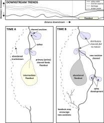
美国亚利桑那州小科罗拉多河溪谷的河道破裂和崩塌

IF 3.1 2区 地球科学 Q2 GEOGRAPHY, PHYSICAL
B.P. Graves , T.J. Ralph , A.M. Morgan
{"title":"美国亚利桑那州小科罗拉多河溪谷的河道破裂和崩塌","authors":"B.P. Graves ,&nbsp;T.J. Ralph ,&nbsp;A.M. Morgan","doi":"10.1016/j.geomorph.2024.109501","DOIUrl":null,"url":null,"abstract":"<div><div>Improved knowledge regarding dryland river character and behaviour is important as the increasing threats of climate change and anthropogenic activities exacerbate water security issues in channels prone to discontinuity and termination. Dryland river character and behaviour is determined by a complex and dynamic interplay between extrinsic controls and intrinsic processes. Polacca and Oraibi Wash are two discontinuous dryland rivers, tributaries of the Little Colorado River in semi-arid, north-eastern Arizona, USA. Valley-scale morphometrics and downstream longitudinal trends were derived from remote sensing and geospatial analyses, hydraulic modelling, and field measurements, to assess the key controls, patterns, and processes driving channel diminution and discontinuity. Both rivers are entrenched along most of their valleys and experience downstream hydro-geomorphic changes as valley confinement eases in their low gradient floodplains. The rivers exhibit non-equilibrium responses to a concomitant decline in calculated discharge (from ∼82 to &lt;4 m<sup>3</sup> s<sup>−1</sup>), stream power (from ∼334 to &lt;5 W m<sup>−2</sup>), and channel cross-sectional area (from ∼82 to &lt;3 m<sup>2</sup>), which are the principal factors contributing to channel breakdown and the development of broad floodouts. Small distributary channels and avulsions are evident in the lowland reaches where channel discontinuity occurs, with a dominance of knickpoints in distal floodout reaches as they attempt to re-establish channel continuity. Using historical aerial imagery we show that knickpoint headcut retreat rates have ranged from ∼1.7 to 53 m a<sup>−1</sup>. Channel breakdown patterns and processes in the Polacca and Oraibi Washes are similar to other dryland rivers around the world, and reveal common underlying factors that are central to river termination and reformation. This study reveals a combination of intrinsic erosion and sedimentation processes and avulsion threshold responses that trigger channel adjustment resulting from downstream fluvial decline. However, key extrinsic controls, such as valley confinement and hydroclimate, influence and limit the rate and nature of these adjustments. Early recognition of these geomorphic changes can inform river, land, and water management strategies across the American southwest.</div></div>","PeriodicalId":55115,"journal":{"name":"Geomorphology","volume":"468 ","pages":"Article 109501"},"PeriodicalIF":3.1000,"publicationDate":"2024-11-07","publicationTypes":"Journal Article","fieldsOfStudy":null,"isOpenAccess":false,"openAccessPdf":"","citationCount":"0","resultStr":"{\"title\":\"Channel breakdown and avulsion in arroyos feeding the Little Colorado River, Arizona, USA\",\"authors\":\"B.P. Graves ,&nbsp;T.J. Ralph ,&nbsp;A.M. Morgan\",\"doi\":\"10.1016/j.geomorph.2024.109501\",\"DOIUrl\":null,\"url\":null,\"abstract\":\"<div><div>Improved knowledge regarding dryland river character and behaviour is important as the increasing threats of climate change and anthropogenic activities exacerbate water security issues in channels prone to discontinuity and termination. Dryland river character and behaviour is determined by a complex and dynamic interplay between extrinsic controls and intrinsic processes. Polacca and Oraibi Wash are two discontinuous dryland rivers, tributaries of the Little Colorado River in semi-arid, north-eastern Arizona, USA. Valley-scale morphometrics and downstream longitudinal trends were derived from remote sensing and geospatial analyses, hydraulic modelling, and field measurements, to assess the key controls, patterns, and processes driving channel diminution and discontinuity. Both rivers are entrenched along most of their valleys and experience downstream hydro-geomorphic changes as valley confinement eases in their low gradient floodplains. The rivers exhibit non-equilibrium responses to a concomitant decline in calculated discharge (from ∼82 to &lt;4 m<sup>3</sup> s<sup>−1</sup>), stream power (from ∼334 to &lt;5 W m<sup>−2</sup>), and channel cross-sectional area (from ∼82 to &lt;3 m<sup>2</sup>), which are the principal factors contributing to channel breakdown and the development of broad floodouts. Small distributary channels and avulsions are evident in the lowland reaches where channel discontinuity occurs, with a dominance of knickpoints in distal floodout reaches as they attempt to re-establish channel continuity. Using historical aerial imagery we show that knickpoint headcut retreat rates have ranged from ∼1.7 to 53 m a<sup>−1</sup>. Channel breakdown patterns and processes in the Polacca and Oraibi Washes are similar to other dryland rivers around the world, and reveal common underlying factors that are central to river termination and reformation. This study reveals a combination of intrinsic erosion and sedimentation processes and avulsion threshold responses that trigger channel adjustment resulting from downstream fluvial decline. However, key extrinsic controls, such as valley confinement and hydroclimate, influence and limit the rate and nature of these adjustments. Early recognition of these geomorphic changes can inform river, land, and water management strategies across the American southwest.</div></div>\",\"PeriodicalId\":55115,\"journal\":{\"name\":\"Geomorphology\",\"volume\":\"468 \",\"pages\":\"Article 109501\"},\"PeriodicalIF\":3.1000,\"publicationDate\":\"2024-11-07\",\"publicationTypes\":\"Journal Article\",\"fieldsOfStudy\":null,\"isOpenAccess\":false,\"openAccessPdf\":\"\",\"citationCount\":\"0\",\"resultStr\":null,\"platform\":\"Semanticscholar\",\"paperid\":null,\"PeriodicalName\":\"Geomorphology\",\"FirstCategoryId\":\"89\",\"ListUrlMain\":\"https://www.sciencedirect.com/science/article/pii/S0169555X24004537\",\"RegionNum\":2,\"RegionCategory\":\"地球科学\",\"ArticlePicture\":[],\"TitleCN\":null,\"AbstractTextCN\":null,\"PMCID\":null,\"EPubDate\":\"\",\"PubModel\":\"\",\"JCR\":\"Q2\",\"JCRName\":\"GEOGRAPHY, PHYSICAL\",\"Score\":null,\"Total\":0}","platform":"Semanticscholar","paperid":null,"PeriodicalName":"Geomorphology","FirstCategoryId":"89","ListUrlMain":"https://www.sciencedirect.com/science/article/pii/S0169555X24004537","RegionNum":2,"RegionCategory":"地球科学","ArticlePicture":[],"TitleCN":null,"AbstractTextCN":null,"PMCID":null,"EPubDate":"","PubModel":"","JCR":"Q2","JCRName":"GEOGRAPHY, PHYSICAL","Score":null,"Total":0}
引用次数: 0

摘要

气候变化和人为活动的威胁日益严重,加剧了易发生断流和终止的河道的水安全问题,因此,提高对旱地河流特征和行为的认识非常重要。旱地河流的特征和行为是由外在控制和内在过程之间复杂而动态的相互作用决定的。Polacca 和 Oraibi Wash 是两条不连续的旱地河流,是美国亚利桑那州东北部半干旱地区小科罗拉多河的支流。通过遥感和地理空间分析、水力模型和实地测量,得出了河谷尺度的形态计量学和下游纵向趋势,以评估驱动河道缩小和不连续的关键控制因素、模式和过程。这两条河流的大部分河谷都有淤积,随着低坡度洪泛区河谷淤积的缓解,下游的水文地质也会发生变化。这两条河流的计算排泄量(从 82 m3 s-1 到 4 m3 s-1)、水流功率(从 334 W m-2 到 5 W m-2)和河道横截面积(从 82 m2 到 3 m2)都出现了非均衡反应,这是导致河道断裂和大面积洪泛的主要因素。在发生河道断裂的低洼地段,小的支流河道和崩塌非常明显,而在洪水泛滥的远端,由于试图重建河道的连续性,则以节理点为主。我们利用历史航拍图像显示,戗点顶切的后退速度在 1.7 至 53 米/秒之间。波拉克卡和奥赖比冲沟的河道断裂模式和过程与世界上其他旱地河流相似,揭示了河流终止和改造的共同基本因素。这项研究揭示了内在侵蚀和沉积过程与崩塌阈值反应的结合,它们触发了河道调整,导致下游河道衰退。然而,河谷封闭性和水文气候等关键的外在控制因素也会影响和限制这些调整的速度和性质。及早认识到这些地貌变化可以为美国西南部的河流、土地和水资源管理策略提供参考。
本文章由计算机程序翻译,如有差异,请以英文原文为准。

Channel breakdown and avulsion in arroyos feeding the Little Colorado River, Arizona, USA

Channel breakdown and avulsion in arroyos feeding the Little Colorado River, Arizona, USA
Improved knowledge regarding dryland river character and behaviour is important as the increasing threats of climate change and anthropogenic activities exacerbate water security issues in channels prone to discontinuity and termination. Dryland river character and behaviour is determined by a complex and dynamic interplay between extrinsic controls and intrinsic processes. Polacca and Oraibi Wash are two discontinuous dryland rivers, tributaries of the Little Colorado River in semi-arid, north-eastern Arizona, USA. Valley-scale morphometrics and downstream longitudinal trends were derived from remote sensing and geospatial analyses, hydraulic modelling, and field measurements, to assess the key controls, patterns, and processes driving channel diminution and discontinuity. Both rivers are entrenched along most of their valleys and experience downstream hydro-geomorphic changes as valley confinement eases in their low gradient floodplains. The rivers exhibit non-equilibrium responses to a concomitant decline in calculated discharge (from ∼82 to <4 m3 s−1), stream power (from ∼334 to <5 W m−2), and channel cross-sectional area (from ∼82 to <3 m2), which are the principal factors contributing to channel breakdown and the development of broad floodouts. Small distributary channels and avulsions are evident in the lowland reaches where channel discontinuity occurs, with a dominance of knickpoints in distal floodout reaches as they attempt to re-establish channel continuity. Using historical aerial imagery we show that knickpoint headcut retreat rates have ranged from ∼1.7 to 53 m a−1. Channel breakdown patterns and processes in the Polacca and Oraibi Washes are similar to other dryland rivers around the world, and reveal common underlying factors that are central to river termination and reformation. This study reveals a combination of intrinsic erosion and sedimentation processes and avulsion threshold responses that trigger channel adjustment resulting from downstream fluvial decline. However, key extrinsic controls, such as valley confinement and hydroclimate, influence and limit the rate and nature of these adjustments. Early recognition of these geomorphic changes can inform river, land, and water management strategies across the American southwest.
求助全文
通过发布文献求助,成功后即可免费获取论文全文。 去求助
来源期刊
Geomorphology
Geomorphology 地学-地球科学综合
CiteScore
8.00
自引率
10.30%
发文量
309
审稿时长
3.4 months
期刊介绍: Our journal''s scope includes geomorphic themes of: tectonics and regional structure; glacial processes and landforms; fluvial sequences, Quaternary environmental change and dating; fluvial processes and landforms; mass movement, slopes and periglacial processes; hillslopes and soil erosion; weathering, karst and soils; aeolian processes and landforms, coastal dunes and arid environments; coastal and marine processes, estuaries and lakes; modelling, theoretical and quantitative geomorphology; DEM, GIS and remote sensing methods and applications; hazards, applied and planetary geomorphology; and volcanics.
×
引用
GB/T 7714-2015
复制
MLA
复制
APA
复制
导出至
BibTeX EndNote RefMan NoteFirst NoteExpress
×
提示
您的信息不完整,为了账户安全,请先补充。
现在去补充
×
提示
您因"违规操作"
具体请查看互助需知
我知道了
×
提示
确定
请完成安全验证×
copy
已复制链接
快去分享给好友吧!
我知道了
右上角分享
点击右上角分享
0
联系我们:info@booksci.cn Book学术提供免费学术资源搜索服务,方便国内外学者检索中英文文献。致力于提供最便捷和优质的服务体验。 Copyright © 2023 布克学术 All rights reserved.
京ICP备2023020795号-1
ghs 京公网安备 11010802042870号
Book学术文献互助
Book学术文献互助群
群 号:481959085
Book学术官方微信