Yaozu Qin , Li Cao , Shimin Li , Fawang Ye , Ali Darvishi Boloorani , Zhaoxi Liang , Jun Huang , Guofeng Liu
{"title":"多源地球科学数据驱动的城市地区沉降风险评估框架","authors":"Yaozu Qin , Li Cao , Shimin Li , Fawang Ye , Ali Darvishi Boloorani , Zhaoxi Liang , Jun Huang , Guofeng Liu","doi":"10.1016/j.ijdrr.2024.104901","DOIUrl":null,"url":null,"abstract":"<div><div>Land subsidence, especially in developed cities, poses significant risks to human life, social property, and urban sustainability. Taking Liwan District in southern China as an example, this study proposed an acceptable framework for regional land subsidence risk assessment while complying with current national assessment system. With integrating the multi-source geospatial data from remote sensing and various geology surveys into ArcGIS, the subsidence risk assessment was carried out based on the subsidence susceptibility mapping, hazard and vulnerability surveying by using a series of data-driven methods. The results showed that, (<em>i</em>) although not all surface deformations detected by InSAR technology were caused by subsidence, they were instrumental in updating subsidence records; (<em>ii</em>) with the help of spatial correlation analysis using weight evidence as well as multi-source data fusion in high spatial resolution, the Random Forest-based classification models effectively identified the land use types and accurately mapped the land subsidence susceptibility; (<em>iii</em>) the hazard and vulnerability surveying based on a series of newly developed combined weight methods, improved the reliability of risk assessment; (<em>iv</em>) the extremely high- and high-risk areas from the zoning of the land subsidence, provided target areas for further management and prevention of land subsidence. This comprehensive and quantitative assessment framework highlights the need for continued monitoring in subsidence-prone regions, helping to propose strategies for risk mitigation and adaptive planning in urban areas.</div></div>","PeriodicalId":13915,"journal":{"name":"International journal of disaster risk reduction","volume":"113 ","pages":"Article 104901"},"PeriodicalIF":4.2000,"publicationDate":"2024-10-15","publicationTypes":"Journal Article","fieldsOfStudy":null,"isOpenAccess":false,"openAccessPdf":"","citationCount":"0","resultStr":"{\"title\":\"Multisource geoscience data-driven framework for subsidence risk assessment in urban area\",\"authors\":\"Yaozu Qin , Li Cao , Shimin Li , Fawang Ye , Ali Darvishi Boloorani , Zhaoxi Liang , Jun Huang , Guofeng Liu\",\"doi\":\"10.1016/j.ijdrr.2024.104901\",\"DOIUrl\":null,\"url\":null,\"abstract\":\"<div><div>Land subsidence, especially in developed cities, poses significant risks to human life, social property, and urban sustainability. Taking Liwan District in southern China as an example, this study proposed an acceptable framework for regional land subsidence risk assessment while complying with current national assessment system. With integrating the multi-source geospatial data from remote sensing and various geology surveys into ArcGIS, the subsidence risk assessment was carried out based on the subsidence susceptibility mapping, hazard and vulnerability surveying by using a series of data-driven methods. The results showed that, (<em>i</em>) although not all surface deformations detected by InSAR technology were caused by subsidence, they were instrumental in updating subsidence records; (<em>ii</em>) with the help of spatial correlation analysis using weight evidence as well as multi-source data fusion in high spatial resolution, the Random Forest-based classification models effectively identified the land use types and accurately mapped the land subsidence susceptibility; (<em>iii</em>) the hazard and vulnerability surveying based on a series of newly developed combined weight methods, improved the reliability of risk assessment; (<em>iv</em>) the extremely high- and high-risk areas from the zoning of the land subsidence, provided target areas for further management and prevention of land subsidence. This comprehensive and quantitative assessment framework highlights the need for continued monitoring in subsidence-prone regions, helping to propose strategies for risk mitigation and adaptive planning in urban areas.</div></div>\",\"PeriodicalId\":13915,\"journal\":{\"name\":\"International journal of disaster risk reduction\",\"volume\":\"113 \",\"pages\":\"Article 104901\"},\"PeriodicalIF\":4.2000,\"publicationDate\":\"2024-10-15\",\"publicationTypes\":\"Journal Article\",\"fieldsOfStudy\":null,\"isOpenAccess\":false,\"openAccessPdf\":\"\",\"citationCount\":\"0\",\"resultStr\":null,\"platform\":\"Semanticscholar\",\"paperid\":null,\"PeriodicalName\":\"International journal of disaster risk reduction\",\"FirstCategoryId\":\"89\",\"ListUrlMain\":\"https://www.sciencedirect.com/science/article/pii/S2212420924006630\",\"RegionNum\":1,\"RegionCategory\":\"地球科学\",\"ArticlePicture\":[],\"TitleCN\":null,\"AbstractTextCN\":null,\"PMCID\":null,\"EPubDate\":\"\",\"PubModel\":\"\",\"JCR\":\"Q1\",\"JCRName\":\"GEOSCIENCES, MULTIDISCIPLINARY\",\"Score\":null,\"Total\":0}","platform":"Semanticscholar","paperid":null,"PeriodicalName":"International journal of disaster risk reduction","FirstCategoryId":"89","ListUrlMain":"https://www.sciencedirect.com/science/article/pii/S2212420924006630","RegionNum":1,"RegionCategory":"地球科学","ArticlePicture":[],"TitleCN":null,"AbstractTextCN":null,"PMCID":null,"EPubDate":"","PubModel":"","JCR":"Q1","JCRName":"GEOSCIENCES, MULTIDISCIPLINARY","Score":null,"Total":0}
Multisource geoscience data-driven framework for subsidence risk assessment in urban area
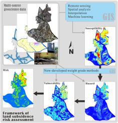
Land subsidence, especially in developed cities, poses significant risks to human life, social property, and urban sustainability. Taking Liwan District in southern China as an example, this study proposed an acceptable framework for regional land subsidence risk assessment while complying with current national assessment system. With integrating the multi-source geospatial data from remote sensing and various geology surveys into ArcGIS, the subsidence risk assessment was carried out based on the subsidence susceptibility mapping, hazard and vulnerability surveying by using a series of data-driven methods. The results showed that, (i) although not all surface deformations detected by InSAR technology were caused by subsidence, they were instrumental in updating subsidence records; (ii) with the help of spatial correlation analysis using weight evidence as well as multi-source data fusion in high spatial resolution, the Random Forest-based classification models effectively identified the land use types and accurately mapped the land subsidence susceptibility; (iii) the hazard and vulnerability surveying based on a series of newly developed combined weight methods, improved the reliability of risk assessment; (iv) the extremely high- and high-risk areas from the zoning of the land subsidence, provided target areas for further management and prevention of land subsidence. This comprehensive and quantitative assessment framework highlights the need for continued monitoring in subsidence-prone regions, helping to propose strategies for risk mitigation and adaptive planning in urban areas.
期刊介绍:
The International Journal of Disaster Risk Reduction (IJDRR) is the journal for researchers, policymakers and practitioners across diverse disciplines: earth sciences and their implications; environmental sciences; engineering; urban studies; geography; and the social sciences. IJDRR publishes fundamental and applied research, critical reviews, policy papers and case studies with a particular focus on multi-disciplinary research that aims to reduce the impact of natural, technological, social and intentional disasters. IJDRR stimulates exchange of ideas and knowledge transfer on disaster research, mitigation, adaptation, prevention and risk reduction at all geographical scales: local, national and international.
Key topics:-
-multifaceted disaster and cascading disasters
-the development of disaster risk reduction strategies and techniques
-discussion and development of effective warning and educational systems for risk management at all levels
-disasters associated with climate change
-vulnerability analysis and vulnerability trends
-emerging risks
-resilience against disasters.
The journal particularly encourages papers that approach risk from a multi-disciplinary perspective.