Jamie MacMahan, Ed Thornton, Stef Dressel, Mike Cook
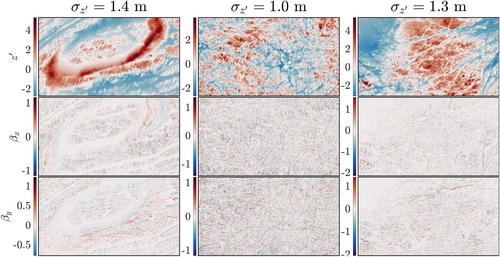
{"title":"加利福尼亚近岸的中波尺度岩底可变性","authors":"Jamie MacMahan, Ed Thornton, Stef Dressel, Mike Cook","doi":"10.1029/2023EA003475","DOIUrl":null,"url":null,"abstract":"<div>\n \n \n <section>\n \n <p>Approximately 75% of the world's and California's shores are rocky. Rocky shores are of biological interest owing to their diverse and productive species assemblages, where waves and currents play a critical role in larval dispersal and recruitment. Surface variability for nearshore <span></span><math>\n <semantics>\n <mrow>\n <mo>(</mo>\n <mrow>\n <mn>5</mn>\n <mo>⪅</mo>\n <mi>d</mi>\n <mi>e</mi>\n <mi>p</mi>\n <mi>t</mi>\n <mi>h</mi>\n <mo>⪅</mo>\n <mn>60</mn>\n <mspace></mspace>\n <mi>m</mi>\n </mrow>\n <mo>)</mo>\n </mrow>\n <annotation> $(5\\lessapprox \\mathrm{d}\\mathrm{e}\\mathrm{p}\\mathrm{t}\\mathrm{h}\\lessapprox 60\\hspace*{.5em}\\mathrm{m})$</annotation>\n </semantics></math> rocky bottoms at intermediate wave scale <span></span><math>\n <semantics>\n <mrow>\n <mfenced>\n <mrow>\n <mn>1</mn>\n <mo>/</mo>\n <mn>750</mn>\n <mo><</mo>\n <mi>k</mi>\n <mo><</mo>\n <mn>1</mn>\n <mo>/</mo>\n <mn>4</mn>\n <mspace></mspace>\n <msup>\n <mi>m</mi>\n <mrow>\n <mo>−</mo>\n <mn>1</mn>\n </mrow>\n </msup>\n </mrow>\n </mfenced>\n </mrow>\n <annotation> $\\left(1/750< k< 1/4\\hspace*{.5em}{\\mathrm{m}}^{-1}\\right)$</annotation>\n </semantics></math> is described for the first time using existing high-resolution bathymetric surveys extending the length of California. The vertical variability of rocky shores is three times larger than measured coral reefs at the reef scale of <span></span><math>\n <semantics>\n <mrow>\n <mn>1</mn>\n <mo>/</mo>\n <mn>64</mn>\n <mo><</mo>\n <mi>k</mi>\n <mo><</mo>\n <mn>1</mn>\n <mo>/</mo>\n <mn>4</mn>\n <mspace></mspace>\n <msup>\n <mi>m</mi>\n <mrow>\n <mo>−</mo>\n <mn>1</mn>\n </mrow>\n </msup>\n </mrow>\n <annotation> $1/64< k< 1/4\\hspace*{.5em}{\\mathrm{m}}^{-1}$</annotation>\n </semantics></math>. The ensemble-averaged, normalized, wavenumber elevation spectra are self-similar, with at least two negative power-law slope regions of 1.3 indicating rough bottoms and 2.75 at high wavenumbers indicating smoother-filled depressions. The ensemble statistics for rocky bottoms appear isotropic based on their cross-shore and alongshore variances and wave number slope spectra being statistically equal. Isotropy is attributed to wave erosion over time that only occurs in the nearshore ocean region. A Fourier spectral representation of the bottom boundary condition, <span></span><math>\n <semantics>\n <mrow>\n <msub>\n <mover>\n <mi>G</mi>\n <mo>‾</mo>\n </mover>\n <msup>\n <mi>z</mi>\n <mo>′</mo>\n </msup>\n </msub>\n </mrow>\n <annotation> ${\\overline{G}}_{{z}^{\\prime }}$</annotation>\n </semantics></math>, is developed for wave and current-driven hydrodynamic models along rocky coasts. The model has an error of less than 2% relative to the observed spectral data for reconstructive profiles and surfaces.</p>\n </section>\n </div>","PeriodicalId":54286,"journal":{"name":"Earth and Space Science","volume":"11 10","pages":""},"PeriodicalIF":2.9000,"publicationDate":"2024-10-19","publicationTypes":"Journal Article","fieldsOfStudy":null,"isOpenAccess":false,"openAccessPdf":"https://onlinelibrary.wiley.com/doi/epdf/10.1029/2023EA003475","citationCount":"0","resultStr":"{\"title\":\"Intermediate Wave Scale Rocky Bottom Variability for the Nearshore Along California\",\"authors\":\"Jamie MacMahan, Ed Thornton, Stef Dressel, Mike Cook\",\"doi\":\"10.1029/2023EA003475\",\"DOIUrl\":null,\"url\":null,\"abstract\":\"<div>\\n \\n \\n <section>\\n \\n <p>Approximately 75% of the world's and California's shores are rocky. Rocky shores are of biological interest owing to their diverse and productive species assemblages, where waves and currents play a critical role in larval dispersal and recruitment. Surface variability for nearshore <span></span><math>\\n <semantics>\\n <mrow>\\n <mo>(</mo>\\n <mrow>\\n <mn>5</mn>\\n <mo>⪅</mo>\\n <mi>d</mi>\\n <mi>e</mi>\\n <mi>p</mi>\\n <mi>t</mi>\\n <mi>h</mi>\\n <mo>⪅</mo>\\n <mn>60</mn>\\n <mspace></mspace>\\n <mi>m</mi>\\n </mrow>\\n <mo>)</mo>\\n </mrow>\\n <annotation> $(5\\\\lessapprox \\\\mathrm{d}\\\\mathrm{e}\\\\mathrm{p}\\\\mathrm{t}\\\\mathrm{h}\\\\lessapprox 60\\\\hspace*{.5em}\\\\mathrm{m})$</annotation>\\n </semantics></math> rocky bottoms at intermediate wave scale <span></span><math>\\n <semantics>\\n <mrow>\\n <mfenced>\\n <mrow>\\n <mn>1</mn>\\n <mo>/</mo>\\n <mn>750</mn>\\n <mo><</mo>\\n <mi>k</mi>\\n <mo><</mo>\\n <mn>1</mn>\\n <mo>/</mo>\\n <mn>4</mn>\\n <mspace></mspace>\\n <msup>\\n <mi>m</mi>\\n <mrow>\\n <mo>−</mo>\\n <mn>1</mn>\\n </mrow>\\n </msup>\\n </mrow>\\n </mfenced>\\n </mrow>\\n <annotation> $\\\\left(1/750< k< 1/4\\\\hspace*{.5em}{\\\\mathrm{m}}^{-1}\\\\right)$</annotation>\\n </semantics></math> is described for the first time using existing high-resolution bathymetric surveys extending the length of California. The vertical variability of rocky shores is three times larger than measured coral reefs at the reef scale of <span></span><math>\\n <semantics>\\n <mrow>\\n <mn>1</mn>\\n <mo>/</mo>\\n <mn>64</mn>\\n <mo><</mo>\\n <mi>k</mi>\\n <mo><</mo>\\n <mn>1</mn>\\n <mo>/</mo>\\n <mn>4</mn>\\n <mspace></mspace>\\n <msup>\\n <mi>m</mi>\\n <mrow>\\n <mo>−</mo>\\n <mn>1</mn>\\n </mrow>\\n </msup>\\n </mrow>\\n <annotation> $1/64< k< 1/4\\\\hspace*{.5em}{\\\\mathrm{m}}^{-1}$</annotation>\\n </semantics></math>. The ensemble-averaged, normalized, wavenumber elevation spectra are self-similar, with at least two negative power-law slope regions of 1.3 indicating rough bottoms and 2.75 at high wavenumbers indicating smoother-filled depressions. The ensemble statistics for rocky bottoms appear isotropic based on their cross-shore and alongshore variances and wave number slope spectra being statistically equal. Isotropy is attributed to wave erosion over time that only occurs in the nearshore ocean region. A Fourier spectral representation of the bottom boundary condition, <span></span><math>\\n <semantics>\\n <mrow>\\n <msub>\\n <mover>\\n <mi>G</mi>\\n <mo>‾</mo>\\n </mover>\\n <msup>\\n <mi>z</mi>\\n <mo>′</mo>\\n </msup>\\n </msub>\\n </mrow>\\n <annotation> ${\\\\overline{G}}_{{z}^{\\\\prime }}$</annotation>\\n </semantics></math>, is developed for wave and current-driven hydrodynamic models along rocky coasts. The model has an error of less than 2% relative to the observed spectral data for reconstructive profiles and surfaces.</p>\\n </section>\\n </div>\",\"PeriodicalId\":54286,\"journal\":{\"name\":\"Earth and Space Science\",\"volume\":\"11 10\",\"pages\":\"\"},\"PeriodicalIF\":2.9000,\"publicationDate\":\"2024-10-19\",\"publicationTypes\":\"Journal Article\",\"fieldsOfStudy\":null,\"isOpenAccess\":false,\"openAccessPdf\":\"https://onlinelibrary.wiley.com/doi/epdf/10.1029/2023EA003475\",\"citationCount\":\"0\",\"resultStr\":null,\"platform\":\"Semanticscholar\",\"paperid\":null,\"PeriodicalName\":\"Earth and Space Science\",\"FirstCategoryId\":\"89\",\"ListUrlMain\":\"https://onlinelibrary.wiley.com/doi/10.1029/2023EA003475\",\"RegionNum\":3,\"RegionCategory\":\"地球科学\",\"ArticlePicture\":[],\"TitleCN\":null,\"AbstractTextCN\":null,\"PMCID\":null,\"EPubDate\":\"\",\"PubModel\":\"\",\"JCR\":\"Q2\",\"JCRName\":\"ASTRONOMY & ASTROPHYSICS\",\"Score\":null,\"Total\":0}","platform":"Semanticscholar","paperid":null,"PeriodicalName":"Earth and Space Science","FirstCategoryId":"89","ListUrlMain":"https://onlinelibrary.wiley.com/doi/10.1029/2023EA003475","RegionNum":3,"RegionCategory":"地球科学","ArticlePicture":[],"TitleCN":null,"AbstractTextCN":null,"PMCID":null,"EPubDate":"","PubModel":"","JCR":"Q2","JCRName":"ASTRONOMY & ASTROPHYSICS","Score":null,"Total":0}
引用次数: 0
摘要
全世界和加利福尼亚州约有 75% 的海岸是岩石海岸。岩石海岸因其多样且富饶的物种组合而备受生物界关注,其中波浪和海流对幼虫的扩散和繁殖起着至关重要的作用。Surface variability for nearshore ( 5 ⪅ d e p t h ⪅ 60 m ) $(5\lessapprox \mathrm{d}\mathrm{e}\mathrm{p}\mathrm{t}\mathrm{h}\lessapprox 60\hspace*{.5em}\mathrm{m})$ rocky bottoms at intermediate wave scale 1 / 750 < k < 1 / 4 m − 1 $\left(1/750< k< 1/4\hspace*{.5em}{\mathrm{m}}^{-1}\right)$ is described for the first time using existing high-resolution bathymetric surveys extending the length of California.在 1 / 64 < k < 1 / 4 m - 1 $1/64 < k < 1/4\hspace*{.5em}{mathrm{m}}^{-1}$ 的珊瑚礁尺度下,岩石海岸的垂直变化比测量的珊瑚礁大三倍。经过归一化处理的集合平均波数高程谱具有自相似性,至少有两个负幂律斜率区域,1.3 表示粗糙的底部,2.75 的高波数表示较平滑的凹陷。岩质海底的集合统计量似乎是各向同性的,因为它们的跨岸和沿岸方差以及波数斜率谱在统计上是相等的。各向同性的原因是波浪随时间的侵蚀只发生在近岸海洋区域。为沿岩石海岸的波浪和海流驱动的水动力模型开发了海底边界条件 G‾z ′ ${\overline{G}}_{{z}^{\prime }}$ 的傅立叶谱表示法。相对于重建剖面和表面的观测光谱数据,该模型的误差小于 2%。
Intermediate Wave Scale Rocky Bottom Variability for the Nearshore Along California
Approximately 75% of the world's and California's shores are rocky. Rocky shores are of biological interest owing to their diverse and productive species assemblages, where waves and currents play a critical role in larval dispersal and recruitment. Surface variability for nearshore rocky bottoms at intermediate wave scale is described for the first time using existing high-resolution bathymetric surveys extending the length of California. The vertical variability of rocky shores is three times larger than measured coral reefs at the reef scale of . The ensemble-averaged, normalized, wavenumber elevation spectra are self-similar, with at least two negative power-law slope regions of 1.3 indicating rough bottoms and 2.75 at high wavenumbers indicating smoother-filled depressions. The ensemble statistics for rocky bottoms appear isotropic based on their cross-shore and alongshore variances and wave number slope spectra being statistically equal. Isotropy is attributed to wave erosion over time that only occurs in the nearshore ocean region. A Fourier spectral representation of the bottom boundary condition, , is developed for wave and current-driven hydrodynamic models along rocky coasts. The model has an error of less than 2% relative to the observed spectral data for reconstructive profiles and surfaces.
期刊介绍:
Marking AGU’s second new open access journal in the last 12 months, Earth and Space Science is the only journal that reflects the expansive range of science represented by AGU’s 62,000 members, including all of the Earth, planetary, and space sciences, and related fields in environmental science, geoengineering, space engineering, and biogeochemistry.

 求助内容:
求助内容: 应助结果提醒方式:


