{"title":"机器学习驱动的中国臭氧暴露与健康风险时空分析","authors":"Chendong Ma, Jun Song, Maohao Ran, Zhenglin Wan, Yike Guo, Meng Gao","doi":"10.1029/2024JD041593","DOIUrl":null,"url":null,"abstract":"<p>Accurate and fine-scaled prediction of ozone concentrations across space and time, as well as the assessment of associated human risks, is crucial for protecting public health and promoting environmental conservation. This paper introduces NetGBM, an innovative machine-learning model designed to comprehensively model ozone levels across China's diverse topography and analyze the spatiotemporal distribution of ozone and exposure. Our model focuses on daily, weekly, and monthly predictions, achieving commendable <span></span><math>\n <semantics>\n <mrow>\n <msup>\n <mi>R</mi>\n <mn>2</mn>\n </msup>\n </mrow>\n <annotation> ${\\mathrm{R}}^{2}$</annotation>\n </semantics></math> coefficients of 0.83, 0.77, and 0.79, respectively. By constructing a gridded map of ozone and incorporating both land use and meteorological features into each grid, we achieved ozone prediction at a high spatiotemporal resolution, outperforming previous research in terms of performance and scale, particularly in regions with limited monitoring stations. The results can be further improved when applied to regional research using meteorological and ozone data from regional stations. Additionally, our research revealed that temperature is the most significant factor affecting ozone concentrations across China. In health risk assessment, we retrieved a high-resolution spatial distribution of ozone-attributed mortality for 5-COD and daily ozone inhalation distributions during our study period. We concluded that ozone-attributed mortality is predominantly caused by stroke and IHD, accounting for more than 70% of the total deaths in 2021, with the highest mortality rates in developed urban areas such as the NCP and the YRD. Our experiment demonstrated the potential of NetGBM in robustly modeling ozone across China with high spatiotemporal resolution and its applicability in measuring associated health risks.</p>","PeriodicalId":15986,"journal":{"name":"Journal of Geophysical Research: Atmospheres","volume":"129 20","pages":""},"PeriodicalIF":3.8000,"publicationDate":"2024-10-16","publicationTypes":"Journal Article","fieldsOfStudy":null,"isOpenAccess":false,"openAccessPdf":"https://onlinelibrary.wiley.com/doi/epdf/10.1029/2024JD041593","citationCount":"0","resultStr":"{\"title\":\"Machine Learning-Driven Spatiotemporal Analysis of Ozone Exposure and Health Risks in China\",\"authors\":\"Chendong Ma, Jun Song, Maohao Ran, Zhenglin Wan, Yike Guo, Meng Gao\",\"doi\":\"10.1029/2024JD041593\",\"DOIUrl\":null,\"url\":null,\"abstract\":\"<p>Accurate and fine-scaled prediction of ozone concentrations across space and time, as well as the assessment of associated human risks, is crucial for protecting public health and promoting environmental conservation. This paper introduces NetGBM, an innovative machine-learning model designed to comprehensively model ozone levels across China's diverse topography and analyze the spatiotemporal distribution of ozone and exposure. Our model focuses on daily, weekly, and monthly predictions, achieving commendable <span></span><math>\\n <semantics>\\n <mrow>\\n <msup>\\n <mi>R</mi>\\n <mn>2</mn>\\n </msup>\\n </mrow>\\n <annotation> ${\\\\mathrm{R}}^{2}$</annotation>\\n </semantics></math> coefficients of 0.83, 0.77, and 0.79, respectively. By constructing a gridded map of ozone and incorporating both land use and meteorological features into each grid, we achieved ozone prediction at a high spatiotemporal resolution, outperforming previous research in terms of performance and scale, particularly in regions with limited monitoring stations. The results can be further improved when applied to regional research using meteorological and ozone data from regional stations. Additionally, our research revealed that temperature is the most significant factor affecting ozone concentrations across China. In health risk assessment, we retrieved a high-resolution spatial distribution of ozone-attributed mortality for 5-COD and daily ozone inhalation distributions during our study period. We concluded that ozone-attributed mortality is predominantly caused by stroke and IHD, accounting for more than 70% of the total deaths in 2021, with the highest mortality rates in developed urban areas such as the NCP and the YRD. Our experiment demonstrated the potential of NetGBM in robustly modeling ozone across China with high spatiotemporal resolution and its applicability in measuring associated health risks.</p>\",\"PeriodicalId\":15986,\"journal\":{\"name\":\"Journal of Geophysical Research: Atmospheres\",\"volume\":\"129 20\",\"pages\":\"\"},\"PeriodicalIF\":3.8000,\"publicationDate\":\"2024-10-16\",\"publicationTypes\":\"Journal Article\",\"fieldsOfStudy\":null,\"isOpenAccess\":false,\"openAccessPdf\":\"https://onlinelibrary.wiley.com/doi/epdf/10.1029/2024JD041593\",\"citationCount\":\"0\",\"resultStr\":null,\"platform\":\"Semanticscholar\",\"paperid\":null,\"PeriodicalName\":\"Journal of Geophysical Research: Atmospheres\",\"FirstCategoryId\":\"89\",\"ListUrlMain\":\"https://onlinelibrary.wiley.com/doi/10.1029/2024JD041593\",\"RegionNum\":2,\"RegionCategory\":\"地球科学\",\"ArticlePicture\":[],\"TitleCN\":null,\"AbstractTextCN\":null,\"PMCID\":null,\"EPubDate\":\"\",\"PubModel\":\"\",\"JCR\":\"Q2\",\"JCRName\":\"METEOROLOGY & ATMOSPHERIC SCIENCES\",\"Score\":null,\"Total\":0}","platform":"Semanticscholar","paperid":null,"PeriodicalName":"Journal of Geophysical Research: Atmospheres","FirstCategoryId":"89","ListUrlMain":"https://onlinelibrary.wiley.com/doi/10.1029/2024JD041593","RegionNum":2,"RegionCategory":"地球科学","ArticlePicture":[],"TitleCN":null,"AbstractTextCN":null,"PMCID":null,"EPubDate":"","PubModel":"","JCR":"Q2","JCRName":"METEOROLOGY & ATMOSPHERIC SCIENCES","Score":null,"Total":0}
Machine Learning-Driven Spatiotemporal Analysis of Ozone Exposure and Health Risks in China
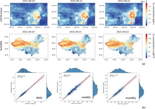
Accurate and fine-scaled prediction of ozone concentrations across space and time, as well as the assessment of associated human risks, is crucial for protecting public health and promoting environmental conservation. This paper introduces NetGBM, an innovative machine-learning model designed to comprehensively model ozone levels across China's diverse topography and analyze the spatiotemporal distribution of ozone and exposure. Our model focuses on daily, weekly, and monthly predictions, achieving commendable coefficients of 0.83, 0.77, and 0.79, respectively. By constructing a gridded map of ozone and incorporating both land use and meteorological features into each grid, we achieved ozone prediction at a high spatiotemporal resolution, outperforming previous research in terms of performance and scale, particularly in regions with limited monitoring stations. The results can be further improved when applied to regional research using meteorological and ozone data from regional stations. Additionally, our research revealed that temperature is the most significant factor affecting ozone concentrations across China. In health risk assessment, we retrieved a high-resolution spatial distribution of ozone-attributed mortality for 5-COD and daily ozone inhalation distributions during our study period. We concluded that ozone-attributed mortality is predominantly caused by stroke and IHD, accounting for more than 70% of the total deaths in 2021, with the highest mortality rates in developed urban areas such as the NCP and the YRD. Our experiment demonstrated the potential of NetGBM in robustly modeling ozone across China with high spatiotemporal resolution and its applicability in measuring associated health risks.
期刊介绍:
JGR: Atmospheres publishes articles that advance and improve understanding of atmospheric properties and processes, including the interaction of the atmosphere with other components of the Earth system.

 求助内容:
求助内容: 应助结果提醒方式:


