加利福尼亚洋流系统中源自高度计的极向拉格朗日路径:第一部分

IF 3.8 3区 地球科学 Q1 OCEANOGRAPHY
{"title":"加利福尼亚洋流系统中源自高度计的极向拉格朗日路径:第一部分","authors":"","doi":"10.1016/j.pocean.2024.103353","DOIUrl":null,"url":null,"abstract":"<div><div>We use altimeter-derived geostrophic velocities, with and without the addition of surface Ekman transports, to create trajectories for virtual parcels in the California Current System (CCS). The goal is to investigate the poleward transport of passive water parcels in the surface 50–100 m of the nominally equatorward system. Motivation for the study is provided by observations of anomalous biomass of copepods with warm water affinities along the Newport Hydrographic Line off central Oregon (44.7°N) during El Niño years, as well as during and following the 2014–2016 marine heat wave. By backward tracking virtual parcels from 44.7°N, we find that the most distant source of passive water parcels in the upper ocean during a one-year period of travel is from within the Southern California Bight (SCB), north of 30°N. To make that journey, parcels use the Inshore Countercurrent off southern and central California during summer–winter and the Davidson Current off northern California and Oregon during autumn–winter. The inclusion of small-scale eddy diffusion usually increases the number of parcels that reach more northern latitudes, while the inclusion of Ekman velocities more often reduces those numbers. Even so, parcels can travel from the SCB to central Oregon in either the Ekman layer or beneath it in the geostrophic flow. Using backward tracking, we find that parcels arrive at 44.7°N most often in winter–spring, least often in autumn. They arrive from within the large-cape region off northern California (41°–42°N) during all years and all months, from just south of the large-cape region (38°–39°N) during most years but seldom in autumn, from south of Monterey Bay along central California (36°N) and within the SCB (34.5°N) during a third (or less) of the years and only in winter-spring. The shortest average transit times are found in winter: for parcels reaching 44.7°N in February, the average transit time is 2 months for parcels coming from 41°–42°N, 4 months for parcels coming from 38°–39°N, and 5–6 months or more for parcels coming from south of 36°N. Transit times increase as the arrival time progresses from winter to autumn. The longest average transit times are for parcels reaching central Oregon in autumn (9–12 months in October for parcels coming from south of 39°N). This makes the journey a multi-generational task for the copepods. Interannual variability in the observed southern copepod species biomass off central Oregon correlates highly with years when more virtual parcels from the south reach central and northern Oregon, providing increased confidence in the results found with the altimeter-derived parcel trajectories.</div></div>","PeriodicalId":20620,"journal":{"name":"Progress in Oceanography","volume":null,"pages":null},"PeriodicalIF":3.8000,"publicationDate":"2024-09-24","publicationTypes":"Journal Article","fieldsOfStudy":null,"isOpenAccess":false,"openAccessPdf":"","citationCount":"0","resultStr":"{\"title\":\"Altimeter-derived poleward Lagrangian pathways in the California Current System: Part 1\",\"authors\":\"\",\"doi\":\"10.1016/j.pocean.2024.103353\",\"DOIUrl\":null,\"url\":null,\"abstract\":\"<div><div>We use altimeter-derived geostrophic velocities, with and without the addition of surface Ekman transports, to create trajectories for virtual parcels in the California Current System (CCS). The goal is to investigate the poleward transport of passive water parcels in the surface 50–100 m of the nominally equatorward system. Motivation for the study is provided by observations of anomalous biomass of copepods with warm water affinities along the Newport Hydrographic Line off central Oregon (44.7°N) during El Niño years, as well as during and following the 2014–2016 marine heat wave. By backward tracking virtual parcels from 44.7°N, we find that the most distant source of passive water parcels in the upper ocean during a one-year period of travel is from within the Southern California Bight (SCB), north of 30°N. To make that journey, parcels use the Inshore Countercurrent off southern and central California during summer–winter and the Davidson Current off northern California and Oregon during autumn–winter. The inclusion of small-scale eddy diffusion usually increases the number of parcels that reach more northern latitudes, while the inclusion of Ekman velocities more often reduces those numbers. Even so, parcels can travel from the SCB to central Oregon in either the Ekman layer or beneath it in the geostrophic flow. Using backward tracking, we find that parcels arrive at 44.7°N most often in winter–spring, least often in autumn. They arrive from within the large-cape region off northern California (41°–42°N) during all years and all months, from just south of the large-cape region (38°–39°N) during most years but seldom in autumn, from south of Monterey Bay along central California (36°N) and within the SCB (34.5°N) during a third (or less) of the years and only in winter-spring. The shortest average transit times are found in winter: for parcels reaching 44.7°N in February, the average transit time is 2 months for parcels coming from 41°–42°N, 4 months for parcels coming from 38°–39°N, and 5–6 months or more for parcels coming from south of 36°N. Transit times increase as the arrival time progresses from winter to autumn. The longest average transit times are for parcels reaching central Oregon in autumn (9–12 months in October for parcels coming from south of 39°N). This makes the journey a multi-generational task for the copepods. Interannual variability in the observed southern copepod species biomass off central Oregon correlates highly with years when more virtual parcels from the south reach central and northern Oregon, providing increased confidence in the results found with the altimeter-derived parcel trajectories.</div></div>\",\"PeriodicalId\":20620,\"journal\":{\"name\":\"Progress in Oceanography\",\"volume\":null,\"pages\":null},\"PeriodicalIF\":3.8000,\"publicationDate\":\"2024-09-24\",\"publicationTypes\":\"Journal Article\",\"fieldsOfStudy\":null,\"isOpenAccess\":false,\"openAccessPdf\":\"\",\"citationCount\":\"0\",\"resultStr\":null,\"platform\":\"Semanticscholar\",\"paperid\":null,\"PeriodicalName\":\"Progress in Oceanography\",\"FirstCategoryId\":\"89\",\"ListUrlMain\":\"https://www.sciencedirect.com/science/article/pii/S0079661124001599\",\"RegionNum\":3,\"RegionCategory\":\"地球科学\",\"ArticlePicture\":[],\"TitleCN\":null,\"AbstractTextCN\":null,\"PMCID\":null,\"EPubDate\":\"\",\"PubModel\":\"\",\"JCR\":\"Q1\",\"JCRName\":\"OCEANOGRAPHY\",\"Score\":null,\"Total\":0}","platform":"Semanticscholar","paperid":null,"PeriodicalName":"Progress in Oceanography","FirstCategoryId":"89","ListUrlMain":"https://www.sciencedirect.com/science/article/pii/S0079661124001599","RegionNum":3,"RegionCategory":"地球科学","ArticlePicture":[],"TitleCN":null,"AbstractTextCN":null,"PMCID":null,"EPubDate":"","PubModel":"","JCR":"Q1","JCRName":"OCEANOGRAPHY","Score":null,"Total":0}
引用次数: 0

摘要

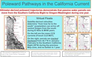
我们利用测高仪得出的地转速度,加上或不加上地表埃克曼传输,为加利福尼亚洋流系统(CCS)中的虚拟水团创建轨迹。目的是研究名义上赤道流系统表层 50-100 米处被动水团的极向输送。在厄尔尼诺年以及 2014-2016 年海洋热浪期间和之后,沿俄勒冈中部(北纬 44.7 度)纽波特水文线观测到具有暖水亲缘关系的桡足类生物量异常,这为研究提供了动机。通过对来自北纬 44.7 度的虚拟包裹进行反向追踪,我们发现,在一年的旅行期间,上层海洋中被动水包裹的最远来源是北纬 30 度以北的南加利福尼亚湾(SCB)。为了完成这次旅行,水团在夏冬季节利用加利福尼亚南部和中部沿海的近岸逆流,在秋冬季节利用加利福尼亚北部和俄勒冈州沿海的戴维森洋流。加入小尺度涡扩散通常会增加到达更北纬度的包裹数量,而加入埃克曼速度通常会减少包裹数量。即便如此,包裹还是可以在 Ekman 层或 Ekman 层下的地转流中从 SCB 到达俄勒冈中部。通过逆向追踪,我们发现包裹到达北纬 44.7 度的时间以冬春季最多,秋季最少。它们在所有年份和所有月份都从北加州北部近海的大海湾地区(北纬 41°-42°)到达,在大多数年份从大海湾地区以南(北纬 38°-39°)到达,但很少在秋季到达,在三分之一(或更少)的年份从蒙特雷湾以南沿加州中部(北纬 36°)和南加州边界(北纬 34.5°)到达,而且只在冬春季节到达。冬季的平均过境时间最短:就二月份到达北纬 44.7 度的包裹而言,来自北纬 41 度至 42 度的包裹的平均过境时间为 2 个月,来自北纬 38 度至 39 度的包裹的平均过境时间为 4 个月,来自北纬 36 度以南的包裹的平均过境时间为 5-6 个月或更长。从冬季到秋季,到达时间越长,转运时间越长。秋季到达俄勒冈州中部的包裹平均运输时间最长(来自北纬 39 度以南的包裹在 10 月份需要 9-12 个月)。这使得桡足类的旅程要经历多代。在俄勒冈州中部沿海观测到的南部桡足类物种生物量的年际变化,与更多来自南部的虚拟包裹到达俄勒冈州中部和北部的年份高度相关,从而增加了对通过高度计推导出的包裹轨迹所发现结果的信心。
本文章由计算机程序翻译,如有差异,请以英文原文为准。

Altimeter-derived poleward Lagrangian pathways in the California Current System: Part 1

Altimeter-derived poleward Lagrangian pathways in the California Current System: Part 1
We use altimeter-derived geostrophic velocities, with and without the addition of surface Ekman transports, to create trajectories for virtual parcels in the California Current System (CCS). The goal is to investigate the poleward transport of passive water parcels in the surface 50–100 m of the nominally equatorward system. Motivation for the study is provided by observations of anomalous biomass of copepods with warm water affinities along the Newport Hydrographic Line off central Oregon (44.7°N) during El Niño years, as well as during and following the 2014–2016 marine heat wave. By backward tracking virtual parcels from 44.7°N, we find that the most distant source of passive water parcels in the upper ocean during a one-year period of travel is from within the Southern California Bight (SCB), north of 30°N. To make that journey, parcels use the Inshore Countercurrent off southern and central California during summer–winter and the Davidson Current off northern California and Oregon during autumn–winter. The inclusion of small-scale eddy diffusion usually increases the number of parcels that reach more northern latitudes, while the inclusion of Ekman velocities more often reduces those numbers. Even so, parcels can travel from the SCB to central Oregon in either the Ekman layer or beneath it in the geostrophic flow. Using backward tracking, we find that parcels arrive at 44.7°N most often in winter–spring, least often in autumn. They arrive from within the large-cape region off northern California (41°–42°N) during all years and all months, from just south of the large-cape region (38°–39°N) during most years but seldom in autumn, from south of Monterey Bay along central California (36°N) and within the SCB (34.5°N) during a third (or less) of the years and only in winter-spring. The shortest average transit times are found in winter: for parcels reaching 44.7°N in February, the average transit time is 2 months for parcels coming from 41°–42°N, 4 months for parcels coming from 38°–39°N, and 5–6 months or more for parcels coming from south of 36°N. Transit times increase as the arrival time progresses from winter to autumn. The longest average transit times are for parcels reaching central Oregon in autumn (9–12 months in October for parcels coming from south of 39°N). This makes the journey a multi-generational task for the copepods. Interannual variability in the observed southern copepod species biomass off central Oregon correlates highly with years when more virtual parcels from the south reach central and northern Oregon, providing increased confidence in the results found with the altimeter-derived parcel trajectories.
求助全文
通过发布文献求助,成功后即可免费获取论文全文。 去求助
来源期刊
Progress in Oceanography
Progress in Oceanography 地学-海洋学
CiteScore
7.20
自引率
4.90%
发文量
138
审稿时长
3 months
期刊介绍: Progress in Oceanography publishes the longer, more comprehensive papers that most oceanographers feel are necessary, on occasion, to do justice to their work. Contributions are generally either a review of an aspect of oceanography or a treatise on an expanding oceanographic subject. The articles cover the entire spectrum of disciplines within the science of oceanography. Occasionally volumes are devoted to collections of papers and conference proceedings of exceptional interest. Essential reading for all oceanographers.
×
引用
GB/T 7714-2015
复制
MLA
复制
APA
复制
导出至
BibTeX EndNote RefMan NoteFirst NoteExpress
×
提示
您的信息不完整,为了账户安全,请先补充。
现在去补充
×
提示
您因"违规操作"
具体请查看互助需知
我知道了
×
提示
确定
请完成安全验证×
copy
已复制链接
快去分享给好友吧!
我知道了
右上角分享
点击右上角分享
0
联系我们:info@booksci.cn Book学术提供免费学术资源搜索服务,方便国内外学者检索中英文文献。致力于提供最便捷和优质的服务体验。 Copyright © 2023 布克学术 All rights reserved.
京ICP备2023020795号-1
ghs 京公网安备 11010802042870号
Book学术文献互助
Book学术文献互助群
群 号:481959085
Book学术官方微信