实现可持续发展目标:利用多数据遥感融合监测埃及尼罗河谷地下水诱发的基岩沉降动态

IF 4.9 Q2 ENGINEERING, ENVIRONMENTAL
Shaimaa M. El-Hadidy
{"title":"实现可持续发展目标:利用多数据遥感融合监测埃及尼罗河谷地下水诱发的基岩沉降动态","authors":"Shaimaa M. El-Hadidy","doi":"10.1016/j.gsd.2024.101353","DOIUrl":null,"url":null,"abstract":"<div><div>Egypt's Golden Triangle megaproject within Egypt's vision 2030, involving land reclamation in Qena Bend's densely populated governorate, develops sustainable land management strategies. Advanced technologies and low-cost remote sensing multi-data fusion are utilized to understand subsidence dynamics influenced by geologic structure, groundwater, climate change, and human activities in Egypt's Nile Valley. This approach identifies environmental hazards and provides a detailed explanation for groundwater-induced bedrock subsidence, aiding in informed decision-making and risk avoidance. Landsat images reveal 13% increased cultivation, 28.28% urban-growth, and decreased water by 8.46%, impacting groundwater resources and controlling the situation. The Gravity Recovery and Climate Experiment(GRACE) and Global Land Data Assimilation System (GLDAS) satellite observations reveal changes in water storage, impacting climate change, groundwater storage dynamics, and aquifer behavior. Historical data indicates a significant southwest-northeast gradient in precipitation from 5 to 60 mm. GLDAS shows soil moisture decline from 0.25 to 0.23 mm. GRACE (total water storage) depleting, then slightly increasing from 2020 to 2023 with an average value (−5 cm/yr). Groundwater storage increases in wet seasons, in 2015 showing (+3–4 mm), less than (+1 mm) in (2018), and (+6–8 mm) in (2020–2023). The NE-SW and NW-SE faults increase hydraulic connection and recharge from aquifers, causing groundwater circulation and karstification in Eocene limestone aquifers, posing risks to urban development and human safety. The InSAR (Synthetic Aperture Radar) measures ground subsidence over time, revealing a range of (−0.04 to −0.07m) in the northwest to (+0.03m) in the southeast, with average subsidence (-4 cm), primarily associated with increased groundwater storage motivate the interaction between the carbonate and groundwater. The ArcGIS overlay model divides the region into three zones: northern, middle, and southern, each with varying degrees of displacement and groundwater storage. The findings emphasize the significance of remote sensing in hazard evaluation for development planning due to its cost-effectiveness and accuracy, applicable globally in hydrogeologically similar areas.</div></div>","PeriodicalId":37879,"journal":{"name":"Groundwater for Sustainable Development","volume":"27 ","pages":"Article 101353"},"PeriodicalIF":4.9000,"publicationDate":"2024-10-10","publicationTypes":"Journal Article","fieldsOfStudy":null,"isOpenAccess":false,"openAccessPdf":"","citationCount":"0","resultStr":"{\"title\":\"Towards sustainable development goals: Leveraging multi-data remote sensing fusion for monitoring groundwater-induced bedrock subsidence dynamics in Egypt's Nile Valley\",\"authors\":\"Shaimaa M. El-Hadidy\",\"doi\":\"10.1016/j.gsd.2024.101353\",\"DOIUrl\":null,\"url\":null,\"abstract\":\"<div><div>Egypt's Golden Triangle megaproject within Egypt's vision 2030, involving land reclamation in Qena Bend's densely populated governorate, develops sustainable land management strategies. Advanced technologies and low-cost remote sensing multi-data fusion are utilized to understand subsidence dynamics influenced by geologic structure, groundwater, climate change, and human activities in Egypt's Nile Valley. This approach identifies environmental hazards and provides a detailed explanation for groundwater-induced bedrock subsidence, aiding in informed decision-making and risk avoidance. Landsat images reveal 13% increased cultivation, 28.28% urban-growth, and decreased water by 8.46%, impacting groundwater resources and controlling the situation. The Gravity Recovery and Climate Experiment(GRACE) and Global Land Data Assimilation System (GLDAS) satellite observations reveal changes in water storage, impacting climate change, groundwater storage dynamics, and aquifer behavior. Historical data indicates a significant southwest-northeast gradient in precipitation from 5 to 60 mm. GLDAS shows soil moisture decline from 0.25 to 0.23 mm. GRACE (total water storage) depleting, then slightly increasing from 2020 to 2023 with an average value (−5 cm/yr). Groundwater storage increases in wet seasons, in 2015 showing (+3–4 mm), less than (+1 mm) in (2018), and (+6–8 mm) in (2020–2023). The NE-SW and NW-SE faults increase hydraulic connection and recharge from aquifers, causing groundwater circulation and karstification in Eocene limestone aquifers, posing risks to urban development and human safety. The InSAR (Synthetic Aperture Radar) measures ground subsidence over time, revealing a range of (−0.04 to −0.07m) in the northwest to (+0.03m) in the southeast, with average subsidence (-4 cm), primarily associated with increased groundwater storage motivate the interaction between the carbonate and groundwater. The ArcGIS overlay model divides the region into three zones: northern, middle, and southern, each with varying degrees of displacement and groundwater storage. The findings emphasize the significance of remote sensing in hazard evaluation for development planning due to its cost-effectiveness and accuracy, applicable globally in hydrogeologically similar areas.</div></div>\",\"PeriodicalId\":37879,\"journal\":{\"name\":\"Groundwater for Sustainable Development\",\"volume\":\"27 \",\"pages\":\"Article 101353\"},\"PeriodicalIF\":4.9000,\"publicationDate\":\"2024-10-10\",\"publicationTypes\":\"Journal Article\",\"fieldsOfStudy\":null,\"isOpenAccess\":false,\"openAccessPdf\":\"\",\"citationCount\":\"0\",\"resultStr\":null,\"platform\":\"Semanticscholar\",\"paperid\":null,\"PeriodicalName\":\"Groundwater for Sustainable Development\",\"FirstCategoryId\":\"1085\",\"ListUrlMain\":\"https://www.sciencedirect.com/science/article/pii/S2352801X24002765\",\"RegionNum\":0,\"RegionCategory\":null,\"ArticlePicture\":[],\"TitleCN\":null,\"AbstractTextCN\":null,\"PMCID\":null,\"EPubDate\":\"\",\"PubModel\":\"\",\"JCR\":\"Q2\",\"JCRName\":\"ENGINEERING, ENVIRONMENTAL\",\"Score\":null,\"Total\":0}","platform":"Semanticscholar","paperid":null,"PeriodicalName":"Groundwater for Sustainable Development","FirstCategoryId":"1085","ListUrlMain":"https://www.sciencedirect.com/science/article/pii/S2352801X24002765","RegionNum":0,"RegionCategory":null,"ArticlePicture":[],"TitleCN":null,"AbstractTextCN":null,"PMCID":null,"EPubDate":"","PubModel":"","JCR":"Q2","JCRName":"ENGINEERING, ENVIRONMENTAL","Score":null,"Total":0}
引用次数: 0

摘要

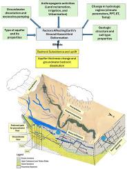
埃及 2030 年远景规划中的埃及金三角大型项目涉及在人口稠密的基纳弯省进行土地开垦,该项目制定了可持续土地管理战略。利用先进技术和低成本遥感多数据融合技术,了解受埃及尼罗河谷地质结构、地下水、气候变化和人类活动影响的沉降动态。这种方法可以识别环境危害,并详细解释地下水引起的基岩沉降,有助于做出明智的决策和规避风险。大地遥感卫星图像显示,耕地面积增加了 13%,城市人口增长了 28.28%,水量减少了 8.46%,从而影响了地下水资源并控制了局势。重力恢复与气候实验(GRACE)和全球陆地数据同化系统(GLDAS)的卫星观测显示了蓄水量的变化,对气候变化、地下水蓄水动态和含水层行为产生了影响。历史数据表明,降水量从 5 毫米到 60 毫米之间呈明显的西南-东北梯度。GLDAS 显示土壤水分从 0.25 毫米下降到 0.23 毫米。全球地下水资源评估(GRACE)(总蓄水量)逐渐减少,然后在 2020 年至 2023 年期间略有增加,平均值(-5 厘米/年)。地下水储量在雨季增加,2015 年为(+3-4 毫米),2018 年小于(+1 毫米),2020-2023 年为(+6-8 毫米)。NE-SW 断层和 NW-SE 断层增加了含水层的水力联系和补给,导致始新世石灰岩含水层的地下水循环和岩溶化,给城市发展和人类安全带来风险。InSAR(合成孔径雷达)测量了随时间变化的地面沉降,显示西北部地面沉降范围为(-0.04 至-0.07 米),东南部地面沉降范围为(+0.03 米),平均下沉(-4 厘米),这主要与碳酸盐岩和地下水之间相互作用促使地下水储量增加有关。ArcGIS 叠加模型将该区域划分为三个区域:北部、中部和南部,每个区域都有不同程度的位移和地下水储存。研究结果表明,遥感技术具有成本效益和准确性,适用于全球水文地质相似地区,因此在发展规划的灾害评估中具有重要意义。
本文章由计算机程序翻译,如有差异,请以英文原文为准。

Towards sustainable development goals: Leveraging multi-data remote sensing fusion for monitoring groundwater-induced bedrock subsidence dynamics in Egypt's Nile Valley

Towards sustainable development goals: Leveraging multi-data remote sensing fusion for monitoring groundwater-induced bedrock subsidence dynamics in Egypt's Nile Valley
Egypt's Golden Triangle megaproject within Egypt's vision 2030, involving land reclamation in Qena Bend's densely populated governorate, develops sustainable land management strategies. Advanced technologies and low-cost remote sensing multi-data fusion are utilized to understand subsidence dynamics influenced by geologic structure, groundwater, climate change, and human activities in Egypt's Nile Valley. This approach identifies environmental hazards and provides a detailed explanation for groundwater-induced bedrock subsidence, aiding in informed decision-making and risk avoidance. Landsat images reveal 13% increased cultivation, 28.28% urban-growth, and decreased water by 8.46%, impacting groundwater resources and controlling the situation. The Gravity Recovery and Climate Experiment(GRACE) and Global Land Data Assimilation System (GLDAS) satellite observations reveal changes in water storage, impacting climate change, groundwater storage dynamics, and aquifer behavior. Historical data indicates a significant southwest-northeast gradient in precipitation from 5 to 60 mm. GLDAS shows soil moisture decline from 0.25 to 0.23 mm. GRACE (total water storage) depleting, then slightly increasing from 2020 to 2023 with an average value (−5 cm/yr). Groundwater storage increases in wet seasons, in 2015 showing (+3–4 mm), less than (+1 mm) in (2018), and (+6–8 mm) in (2020–2023). The NE-SW and NW-SE faults increase hydraulic connection and recharge from aquifers, causing groundwater circulation and karstification in Eocene limestone aquifers, posing risks to urban development and human safety. The InSAR (Synthetic Aperture Radar) measures ground subsidence over time, revealing a range of (−0.04 to −0.07m) in the northwest to (+0.03m) in the southeast, with average subsidence (-4 cm), primarily associated with increased groundwater storage motivate the interaction between the carbonate and groundwater. The ArcGIS overlay model divides the region into three zones: northern, middle, and southern, each with varying degrees of displacement and groundwater storage. The findings emphasize the significance of remote sensing in hazard evaluation for development planning due to its cost-effectiveness and accuracy, applicable globally in hydrogeologically similar areas.
求助全文
通过发布文献求助,成功后即可免费获取论文全文。 去求助
来源期刊
Groundwater for Sustainable Development
Groundwater for Sustainable Development Social Sciences-Geography, Planning and Development
CiteScore
11.50
自引率
10.20%
发文量
152
期刊介绍: Groundwater for Sustainable Development is directed to different stakeholders and professionals, including government and non-governmental organizations, international funding agencies, universities, public water institutions, public health and other public/private sector professionals, and other relevant institutions. It is aimed at professionals, academics and students in the fields of disciplines such as: groundwater and its connection to surface hydrology and environment, soil sciences, engineering, ecology, microbiology, atmospheric sciences, analytical chemistry, hydro-engineering, water technology, environmental ethics, economics, public health, policy, as well as social sciences, legal disciplines, or any other area connected with water issues. The objectives of this journal are to facilitate: • The improvement of effective and sustainable management of water resources across the globe. • The improvement of human access to groundwater resources in adequate quantity and good quality. • The meeting of the increasing demand for drinking and irrigation water needed for food security to contribute to a social and economically sound human development. • The creation of a global inter- and multidisciplinary platform and forum to improve our understanding of groundwater resources and to advocate their effective and sustainable management and protection against contamination. • Interdisciplinary information exchange and to stimulate scientific research in the fields of groundwater related sciences and social and health sciences required to achieve the United Nations Millennium Development Goals for sustainable development.
×
引用
GB/T 7714-2015
复制
MLA
复制
APA
复制
导出至
BibTeX EndNote RefMan NoteFirst NoteExpress
×
提示
您的信息不完整,为了账户安全,请先补充。
现在去补充
×
提示
您因"违规操作"
具体请查看互助需知
我知道了
×
提示
确定
请完成安全验证×
copy
已复制链接
快去分享给好友吧!
我知道了
右上角分享
点击右上角分享
0
联系我们:info@booksci.cn Book学术提供免费学术资源搜索服务,方便国内外学者检索中英文文献。致力于提供最便捷和优质的服务体验。 Copyright © 2023 布克学术 All rights reserved.
京ICP备2023020795号-1
ghs 京公网安备 11010802042870号
Book学术文献互助
Book学术文献互助群
群 号:481959085
Book学术官方微信