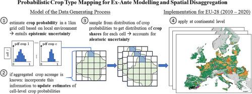
用于事前建模和空间分解的概率作物类型绘图

IF 5.8 2区 环境科学与生态学 Q1 ECOLOGY
Josef Baumert, Thomas Heckelei, Hugo Storm
{"title":"用于事前建模和空间分解的概率作物类型绘图","authors":"Josef Baumert,&nbsp;Thomas Heckelei,&nbsp;Hugo Storm","doi":"10.1016/j.ecoinf.2024.102836","DOIUrl":null,"url":null,"abstract":"<div><div>Agricultural land use and management fundamentally impacts the condition of natural resources like waterbodies, soils, and biodiversity. Modelling the anthropogenic effects on those resources over time requires detailed knowledge of the temporal and spatial distribution of crops. However, currently available crop type maps for Europe either lack the required spatial resolution or the temporal and spatial coverage. We develop and apply a probabilistic, spatially explicit crop type mapping approach that is suitable for ex-post and ex-ante modelling. The approach allows to quantify epistemic and aleatoric uncertainty related to estimated crop shares by providing an ensemble of maps. We implement the method for the EU-28 for the years 2010 – 2020, distinguishing between 28 different crop types at 1 km resolution. Based on a model of the data generating process that conceptually links field-, grid cell- and region-level crop acreages, our approach considers soil, climate, and topography information, as well as administrative data. The validation with ground-truthing data for France indicates that the generated crop type maps are plausible. The provided uncertainty intervals capture differences in uncertainty across space and time and correctly identify grid cells and crops where estimations are less precise. The generated maps constitute a unique data product of high practical value, e.g., for agri-environmental modelling applications. We see additional potential in using the approach to disaggregate the regional or national predictions of socio-economic ex-ante prediction models.</div></div>","PeriodicalId":51024,"journal":{"name":"Ecological Informatics","volume":null,"pages":null},"PeriodicalIF":5.8000,"publicationDate":"2024-09-27","publicationTypes":"Journal Article","fieldsOfStudy":null,"isOpenAccess":false,"openAccessPdf":"","citationCount":"0","resultStr":"{\"title\":\"Probabilistic crop type mapping for ex-ante modelling and spatial disaggregation\",\"authors\":\"Josef Baumert,&nbsp;Thomas Heckelei,&nbsp;Hugo Storm\",\"doi\":\"10.1016/j.ecoinf.2024.102836\",\"DOIUrl\":null,\"url\":null,\"abstract\":\"<div><div>Agricultural land use and management fundamentally impacts the condition of natural resources like waterbodies, soils, and biodiversity. Modelling the anthropogenic effects on those resources over time requires detailed knowledge of the temporal and spatial distribution of crops. However, currently available crop type maps for Europe either lack the required spatial resolution or the temporal and spatial coverage. We develop and apply a probabilistic, spatially explicit crop type mapping approach that is suitable for ex-post and ex-ante modelling. The approach allows to quantify epistemic and aleatoric uncertainty related to estimated crop shares by providing an ensemble of maps. We implement the method for the EU-28 for the years 2010 – 2020, distinguishing between 28 different crop types at 1 km resolution. Based on a model of the data generating process that conceptually links field-, grid cell- and region-level crop acreages, our approach considers soil, climate, and topography information, as well as administrative data. The validation with ground-truthing data for France indicates that the generated crop type maps are plausible. The provided uncertainty intervals capture differences in uncertainty across space and time and correctly identify grid cells and crops where estimations are less precise. The generated maps constitute a unique data product of high practical value, e.g., for agri-environmental modelling applications. We see additional potential in using the approach to disaggregate the regional or national predictions of socio-economic ex-ante prediction models.</div></div>\",\"PeriodicalId\":51024,\"journal\":{\"name\":\"Ecological Informatics\",\"volume\":null,\"pages\":null},\"PeriodicalIF\":5.8000,\"publicationDate\":\"2024-09-27\",\"publicationTypes\":\"Journal Article\",\"fieldsOfStudy\":null,\"isOpenAccess\":false,\"openAccessPdf\":\"\",\"citationCount\":\"0\",\"resultStr\":null,\"platform\":\"Semanticscholar\",\"paperid\":null,\"PeriodicalName\":\"Ecological Informatics\",\"FirstCategoryId\":\"93\",\"ListUrlMain\":\"https://www.sciencedirect.com/science/article/pii/S1574954124003789\",\"RegionNum\":2,\"RegionCategory\":\"环境科学与生态学\",\"ArticlePicture\":[],\"TitleCN\":null,\"AbstractTextCN\":null,\"PMCID\":null,\"EPubDate\":\"\",\"PubModel\":\"\",\"JCR\":\"Q1\",\"JCRName\":\"ECOLOGY\",\"Score\":null,\"Total\":0}","platform":"Semanticscholar","paperid":null,"PeriodicalName":"Ecological Informatics","FirstCategoryId":"93","ListUrlMain":"https://www.sciencedirect.com/science/article/pii/S1574954124003789","RegionNum":2,"RegionCategory":"环境科学与生态学","ArticlePicture":[],"TitleCN":null,"AbstractTextCN":null,"PMCID":null,"EPubDate":"","PubModel":"","JCR":"Q1","JCRName":"ECOLOGY","Score":null,"Total":0}
引用次数: 0

摘要

农业用地的使用和管理从根本上影响着水体、土壤和生物多样性等自然资源的状况。要模拟人为因素对这些资源的长期影响,就必须详细了解作物的时空分布。然而,目前可用的欧洲作物类型图要么缺乏所需的空间分辨率,要么缺乏时空覆盖范围。我们开发并应用了一种适用于事后和事前建模的概率性、空间明确的作物类型绘图方法。该方法可通过提供一系列地图,量化与估计作物份额相关的认识不确定性和不确定性。我们将该方法应用于 2010-2020 年欧盟 28 国,以 1 千米的分辨率区分 28 种不同的作物类型。我们的方法以数据生成过程模型为基础,在概念上将田间、网格单元和区域级作物种植面积联系起来,并考虑了土壤、气候和地形信息以及行政数据。利用法国的地面实况数据进行的验证表明,生成的作物类型图是可信的。所提供的不确定性区间捕捉到了不确定性在空间和时间上的差异,并正确识别了估计精度较低的网格单元和作物。生成的地图是一种独特的数据产品,具有很高的实用价值,例如可用于农业环境建模应用。我们认为,利用这种方法对社会经济事前预测模型的区域或国家预测进行分类还有更大的潜力。
本文章由计算机程序翻译,如有差异,请以英文原文为准。

Probabilistic crop type mapping for ex-ante modelling and spatial disaggregation

Probabilistic crop type mapping for ex-ante modelling and spatial disaggregation
Agricultural land use and management fundamentally impacts the condition of natural resources like waterbodies, soils, and biodiversity. Modelling the anthropogenic effects on those resources over time requires detailed knowledge of the temporal and spatial distribution of crops. However, currently available crop type maps for Europe either lack the required spatial resolution or the temporal and spatial coverage. We develop and apply a probabilistic, spatially explicit crop type mapping approach that is suitable for ex-post and ex-ante modelling. The approach allows to quantify epistemic and aleatoric uncertainty related to estimated crop shares by providing an ensemble of maps. We implement the method for the EU-28 for the years 2010 – 2020, distinguishing between 28 different crop types at 1 km resolution. Based on a model of the data generating process that conceptually links field-, grid cell- and region-level crop acreages, our approach considers soil, climate, and topography information, as well as administrative data. The validation with ground-truthing data for France indicates that the generated crop type maps are plausible. The provided uncertainty intervals capture differences in uncertainty across space and time and correctly identify grid cells and crops where estimations are less precise. The generated maps constitute a unique data product of high practical value, e.g., for agri-environmental modelling applications. We see additional potential in using the approach to disaggregate the regional or national predictions of socio-economic ex-ante prediction models.
求助全文
通过发布文献求助,成功后即可免费获取论文全文。 去求助
来源期刊
Ecological Informatics
Ecological Informatics 环境科学-生态学
CiteScore
8.30
自引率
11.80%
发文量
346
审稿时长
46 days
期刊介绍: The journal Ecological Informatics is devoted to the publication of high quality, peer-reviewed articles on all aspects of computational ecology, data science and biogeography. The scope of the journal takes into account the data-intensive nature of ecology, the growing capacity of information technology to access, harness and leverage complex data as well as the critical need for informing sustainable management in view of global environmental and climate change. The nature of the journal is interdisciplinary at the crossover between ecology and informatics. It focuses on novel concepts and techniques for image- and genome-based monitoring and interpretation, sensor- and multimedia-based data acquisition, internet-based data archiving and sharing, data assimilation, modelling and prediction of ecological data.
×
引用
GB/T 7714-2015
复制
MLA
复制
APA
复制
导出至
BibTeX EndNote RefMan NoteFirst NoteExpress
×
提示
您的信息不完整,为了账户安全,请先补充。
现在去补充
×
提示
您因"违规操作"
具体请查看互助需知
我知道了
×
提示
确定
请完成安全验证×
copy
已复制链接
快去分享给好友吧!
我知道了
右上角分享
点击右上角分享
0
联系我们:info@booksci.cn Book学术提供免费学术资源搜索服务,方便国内外学者检索中英文文献。致力于提供最便捷和优质的服务体验。 Copyright © 2023 布克学术 All rights reserved.
京ICP备2023020795号-1
ghs 京公网安备 11010802042870号
Book学术文献互助
Book学术文献互助群
群 号:481959085
Book学术官方微信