使用 AHP 和 WIOA 模型评估印度查谟和克什米尔 Shopian 地区的地下水质量潜力区:地理信息系统

IF 5.4 Q2 ENGINEERING, ENVIRONMENTAL
{"title":"使用 AHP 和 WIOA 模型评估印度查谟和克什米尔 Shopian 地区的地下水质量潜力区:地理信息系统","authors":"","doi":"10.1016/j.hazadv.2024.100488","DOIUrl":null,"url":null,"abstract":"<div><div>Groundwater is an important natural resource stored in aquifers beneath the earth's surface. The hilly district of Shopian in Jammu and Kashmir serves as a study area due to its present and future groundwater needs. This study aims to assess the groundwater potential zones (GWPZ) in Shopian District using the analytical hierarchy process (AHP) and weighted index overlay analysis (WIOA). The AHP approach attempted to assign weights to specific groundwater recharge characteristics. The various thematic maps, including rainfall, land cover and usage, slope, drainage density, geomorphology, soil, and geology, were integrated using overlay analysis to create a comprehensive GWPZ map. Geographic information system (GIS) and remote sensing (RS) tools were utilized to indicate the potential groundwater existence in the studied area. Four zones were created from the GWPZ: very poor, poor, good, and very good. The analysis showed that the very poor GWPZ is around 35.12 sq km, the poor zone is roughly 166.89 sq km, the excellent zone is approximately 340 sq km, and the very good zone is approximately 66.13 sq km. The present study reveals significant perspectives for organizing and effectively restocking groundwater locations within the district. It intends to safeguard the sustainability of groundwater resources for future generations by promoting their successful development and management.</div></div>","PeriodicalId":73763,"journal":{"name":"Journal of hazardous materials advances","volume":null,"pages":null},"PeriodicalIF":5.4000,"publicationDate":"2024-09-30","publicationTypes":"Journal Article","fieldsOfStudy":null,"isOpenAccess":false,"openAccessPdf":"","citationCount":"0","resultStr":"{\"title\":\"Evaluation of groundwater quality potential zones using AHP and WIOA models in Shopian District, Jammu and Kashmir, India: A GIS\",\"authors\":\"\",\"doi\":\"10.1016/j.hazadv.2024.100488\",\"DOIUrl\":null,\"url\":null,\"abstract\":\"<div><div>Groundwater is an important natural resource stored in aquifers beneath the earth's surface. The hilly district of Shopian in Jammu and Kashmir serves as a study area due to its present and future groundwater needs. This study aims to assess the groundwater potential zones (GWPZ) in Shopian District using the analytical hierarchy process (AHP) and weighted index overlay analysis (WIOA). The AHP approach attempted to assign weights to specific groundwater recharge characteristics. The various thematic maps, including rainfall, land cover and usage, slope, drainage density, geomorphology, soil, and geology, were integrated using overlay analysis to create a comprehensive GWPZ map. Geographic information system (GIS) and remote sensing (RS) tools were utilized to indicate the potential groundwater existence in the studied area. Four zones were created from the GWPZ: very poor, poor, good, and very good. The analysis showed that the very poor GWPZ is around 35.12 sq km, the poor zone is roughly 166.89 sq km, the excellent zone is approximately 340 sq km, and the very good zone is approximately 66.13 sq km. The present study reveals significant perspectives for organizing and effectively restocking groundwater locations within the district. It intends to safeguard the sustainability of groundwater resources for future generations by promoting their successful development and management.</div></div>\",\"PeriodicalId\":73763,\"journal\":{\"name\":\"Journal of hazardous materials advances\",\"volume\":null,\"pages\":null},\"PeriodicalIF\":5.4000,\"publicationDate\":\"2024-09-30\",\"publicationTypes\":\"Journal Article\",\"fieldsOfStudy\":null,\"isOpenAccess\":false,\"openAccessPdf\":\"\",\"citationCount\":\"0\",\"resultStr\":null,\"platform\":\"Semanticscholar\",\"paperid\":null,\"PeriodicalName\":\"Journal of hazardous materials advances\",\"FirstCategoryId\":\"1085\",\"ListUrlMain\":\"https://www.sciencedirect.com/science/article/pii/S2772416624000895\",\"RegionNum\":0,\"RegionCategory\":null,\"ArticlePicture\":[],\"TitleCN\":null,\"AbstractTextCN\":null,\"PMCID\":null,\"EPubDate\":\"\",\"PubModel\":\"\",\"JCR\":\"Q2\",\"JCRName\":\"ENGINEERING, ENVIRONMENTAL\",\"Score\":null,\"Total\":0}","platform":"Semanticscholar","paperid":null,"PeriodicalName":"Journal of hazardous materials advances","FirstCategoryId":"1085","ListUrlMain":"https://www.sciencedirect.com/science/article/pii/S2772416624000895","RegionNum":0,"RegionCategory":null,"ArticlePicture":[],"TitleCN":null,"AbstractTextCN":null,"PMCID":null,"EPubDate":"","PubModel":"","JCR":"Q2","JCRName":"ENGINEERING, ENVIRONMENTAL","Score":null,"Total":0}
引用次数: 0

摘要

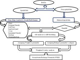
地下水是一种储存在地表下含水层中的重要自然资源。查谟和克什米尔的丘陵地带肖皮安由于其目前和未来的地下水需求而成为研究区域。本研究旨在利用层次分析法(AHP)和加权指数叠加分析法(WIOA)评估肖皮安地区的地下水潜力区(GWPZ)。AHP 方法试图为特定的地下水补给特征分配权重。利用叠加分析法将各种专题地图(包括降雨量、土地覆盖和使用、坡度、排水密度、地貌、土壤和地质)整合在一起,绘制出一幅全面的 GWPZ 地图。地理信息系统(GIS)和遥感(RS)工具被用来指示研究区域内潜在的地下水存在情况。根据 GWPZ 创建了四个区域:极差、差、好和非常好。分析结果表明,极差的 GWPZ 约为 35.12 平方公里,差的区域约为 166.89 平方公里,好的区域约为 340 平方公里,非常好的区域约为 66.13 平方公里。本研究揭示了在该地区组织和有效恢复地下水位置的重要前景。它旨在通过促进地下水资源的成功开发和管理,为子孙后代保护地下水资源的可持续性。
本文章由计算机程序翻译,如有差异,请以英文原文为准。

Evaluation of groundwater quality potential zones using AHP and WIOA models in Shopian District, Jammu and Kashmir, India: A GIS

Evaluation of groundwater quality potential zones using AHP and WIOA models in Shopian District, Jammu and Kashmir, India: A GIS
Groundwater is an important natural resource stored in aquifers beneath the earth's surface. The hilly district of Shopian in Jammu and Kashmir serves as a study area due to its present and future groundwater needs. This study aims to assess the groundwater potential zones (GWPZ) in Shopian District using the analytical hierarchy process (AHP) and weighted index overlay analysis (WIOA). The AHP approach attempted to assign weights to specific groundwater recharge characteristics. The various thematic maps, including rainfall, land cover and usage, slope, drainage density, geomorphology, soil, and geology, were integrated using overlay analysis to create a comprehensive GWPZ map. Geographic information system (GIS) and remote sensing (RS) tools were utilized to indicate the potential groundwater existence in the studied area. Four zones were created from the GWPZ: very poor, poor, good, and very good. The analysis showed that the very poor GWPZ is around 35.12 sq km, the poor zone is roughly 166.89 sq km, the excellent zone is approximately 340 sq km, and the very good zone is approximately 66.13 sq km. The present study reveals significant perspectives for organizing and effectively restocking groundwater locations within the district. It intends to safeguard the sustainability of groundwater resources for future generations by promoting their successful development and management.
求助全文
通过发布文献求助,成功后即可免费获取论文全文。 去求助
来源期刊
Journal of hazardous materials advances
Journal of hazardous materials advances Environmental Engineering
CiteScore
4.80
自引率
0.00%
发文量
0
审稿时长
50 days
×
引用
GB/T 7714-2015
复制
MLA
复制
APA
复制
导出至
BibTeX EndNote RefMan NoteFirst NoteExpress
×
提示
您的信息不完整,为了账户安全,请先补充。
现在去补充
×
提示
您因"违规操作"
具体请查看互助需知
我知道了
×
提示
确定
请完成安全验证×
copy
已复制链接
快去分享给好友吧!
我知道了
右上角分享
点击右上角分享
0
联系我们:info@booksci.cn Book学术提供免费学术资源搜索服务,方便国内外学者检索中英文文献。致力于提供最便捷和优质的服务体验。 Copyright © 2023 布克学术 All rights reserved.
京ICP备2023020795号-1
ghs 京公网安备 11010802042870号
Book学术文献互助
Book学术文献互助群
群 号:481959085
Book学术官方微信