利用机器学习从卫星图像评估气候风险:雅加达洪水风险案例研究

IF 4.8 2区 环境科学与生态学 Q1 ENVIRONMENTAL SCIENCES
Jeasurk Yang , Donghyun Ahn , Junbeom Bahk , Sungwon Park , Nurrokhmah Rizqihandari , Meeyoung Cha
{"title":"利用机器学习从卫星图像评估气候风险:雅加达洪水风险案例研究","authors":"Jeasurk Yang ,&nbsp;Donghyun Ahn ,&nbsp;Junbeom Bahk ,&nbsp;Sungwon Park ,&nbsp;Nurrokhmah Rizqihandari ,&nbsp;Meeyoung Cha","doi":"10.1016/j.crm.2024.100651","DOIUrl":null,"url":null,"abstract":"<div><div>Consistent and timely assessment of climate risks is crucial for planning disaster mitigation and adaptation to climate change at the local community level. This article presents an automatized method for monitoring climate risks with machine learning on satellite imagery, specially targeting riverine and coastal floods. Our research demonstrates that disaster-related risk measurement becomes more comprehensive and multi-faceted by including the following components: hazards, exposure, and vulnerability. Our model first maps hazard-related risks with geo-spatial data, then extends the model to incorporate exposure and vulnerability. In doing so, we adopt a clustering-based supervised algorithm to sort satellite images to produce the climate risk scores at a grid-level. The developed model was tested over multiple ground-truth datasets on flood risks in the region of Jakarta, Indonesia. Results confirm that our model can assess climate risks in a granular scale and further capture potential risks in the marginalized areas (e.g., slums) that were previously hard to predict. We discuss how computational methods like ours can support humanitarian projects for developing countries.</div></div>","PeriodicalId":54226,"journal":{"name":"Climate Risk Management","volume":"46 ","pages":"Article 100651"},"PeriodicalIF":4.8000,"publicationDate":"2024-01-01","publicationTypes":"Journal Article","fieldsOfStudy":null,"isOpenAccess":false,"openAccessPdf":"https://www.sciencedirect.com/science/article/pii/S2212096324000688/pdfft?md5=afa68c0566457d76eda0fe2ad1db09a8&pid=1-s2.0-S2212096324000688-main.pdf","citationCount":"0","resultStr":"{\"title\":\"Assessing climate risks from satellite imagery with machine learning: A case study of flood risks in Jakarta\",\"authors\":\"Jeasurk Yang ,&nbsp;Donghyun Ahn ,&nbsp;Junbeom Bahk ,&nbsp;Sungwon Park ,&nbsp;Nurrokhmah Rizqihandari ,&nbsp;Meeyoung Cha\",\"doi\":\"10.1016/j.crm.2024.100651\",\"DOIUrl\":null,\"url\":null,\"abstract\":\"<div><div>Consistent and timely assessment of climate risks is crucial for planning disaster mitigation and adaptation to climate change at the local community level. This article presents an automatized method for monitoring climate risks with machine learning on satellite imagery, specially targeting riverine and coastal floods. Our research demonstrates that disaster-related risk measurement becomes more comprehensive and multi-faceted by including the following components: hazards, exposure, and vulnerability. Our model first maps hazard-related risks with geo-spatial data, then extends the model to incorporate exposure and vulnerability. In doing so, we adopt a clustering-based supervised algorithm to sort satellite images to produce the climate risk scores at a grid-level. The developed model was tested over multiple ground-truth datasets on flood risks in the region of Jakarta, Indonesia. Results confirm that our model can assess climate risks in a granular scale and further capture potential risks in the marginalized areas (e.g., slums) that were previously hard to predict. We discuss how computational methods like ours can support humanitarian projects for developing countries.</div></div>\",\"PeriodicalId\":54226,\"journal\":{\"name\":\"Climate Risk Management\",\"volume\":\"46 \",\"pages\":\"Article 100651\"},\"PeriodicalIF\":4.8000,\"publicationDate\":\"2024-01-01\",\"publicationTypes\":\"Journal Article\",\"fieldsOfStudy\":null,\"isOpenAccess\":false,\"openAccessPdf\":\"https://www.sciencedirect.com/science/article/pii/S2212096324000688/pdfft?md5=afa68c0566457d76eda0fe2ad1db09a8&pid=1-s2.0-S2212096324000688-main.pdf\",\"citationCount\":\"0\",\"resultStr\":null,\"platform\":\"Semanticscholar\",\"paperid\":null,\"PeriodicalName\":\"Climate Risk Management\",\"FirstCategoryId\":\"93\",\"ListUrlMain\":\"https://www.sciencedirect.com/science/article/pii/S2212096324000688\",\"RegionNum\":2,\"RegionCategory\":\"环境科学与生态学\",\"ArticlePicture\":[],\"TitleCN\":null,\"AbstractTextCN\":null,\"PMCID\":null,\"EPubDate\":\"\",\"PubModel\":\"\",\"JCR\":\"Q1\",\"JCRName\":\"ENVIRONMENTAL SCIENCES\",\"Score\":null,\"Total\":0}","platform":"Semanticscholar","paperid":null,"PeriodicalName":"Climate Risk Management","FirstCategoryId":"93","ListUrlMain":"https://www.sciencedirect.com/science/article/pii/S2212096324000688","RegionNum":2,"RegionCategory":"环境科学与生态学","ArticlePicture":[],"TitleCN":null,"AbstractTextCN":null,"PMCID":null,"EPubDate":"","PubModel":"","JCR":"Q1","JCRName":"ENVIRONMENTAL SCIENCES","Score":null,"Total":0}
引用次数: 0

摘要

对气候风险进行一致而及时的评估,对于在地方社区层面规划减灾和适应气候变化至关重要。本文介绍了一种利用机器学习监测卫星图像气候风险的自动化方法,特别针对河流和沿海洪水。我们的研究表明,与灾害相关的风险测量包括以下组成部分:危害、风险暴露和脆弱性,从而变得更加全面和多面。我们的模型首先利用地理空间数据绘制与灾害相关的风险地图,然后扩展模型,将风险暴露和脆弱性纳入其中。在此过程中,我们采用基于聚类的监督算法对卫星图像进行排序,从而得出网格级的气候风险分数。开发的模型在印度尼西亚雅加达地区的多个洪水风险地面实况数据集上进行了测试。结果证实,我们的模型可以评估细粒度的气候风险,并进一步捕捉到以前难以预测的边缘化地区(如贫民窟)的潜在风险。我们将讨论像我们这样的计算方法如何支持发展中国家的人道主义项目。
本文章由计算机程序翻译,如有差异,请以英文原文为准。

Assessing climate risks from satellite imagery with machine learning: A case study of flood risks in Jakarta

Assessing climate risks from satellite imagery with machine learning: A case study of flood risks in Jakarta
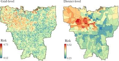
Consistent and timely assessment of climate risks is crucial for planning disaster mitigation and adaptation to climate change at the local community level. This article presents an automatized method for monitoring climate risks with machine learning on satellite imagery, specially targeting riverine and coastal floods. Our research demonstrates that disaster-related risk measurement becomes more comprehensive and multi-faceted by including the following components: hazards, exposure, and vulnerability. Our model first maps hazard-related risks with geo-spatial data, then extends the model to incorporate exposure and vulnerability. In doing so, we adopt a clustering-based supervised algorithm to sort satellite images to produce the climate risk scores at a grid-level. The developed model was tested over multiple ground-truth datasets on flood risks in the region of Jakarta, Indonesia. Results confirm that our model can assess climate risks in a granular scale and further capture potential risks in the marginalized areas (e.g., slums) that were previously hard to predict. We discuss how computational methods like ours can support humanitarian projects for developing countries.
求助全文
通过发布文献求助,成功后即可免费获取论文全文。 去求助
来源期刊
Climate Risk Management
Climate Risk Management Earth and Planetary Sciences-Atmospheric Science
CiteScore
8.20
自引率
4.50%
发文量
76
审稿时长
30 weeks
期刊介绍: Climate Risk Management publishes original scientific contributions, state-of-the-art reviews and reports of practical experience on the use of knowledge and information regarding the consequences of climate variability and climate change in decision and policy making on climate change responses from the near- to long-term. The concept of climate risk management refers to activities and methods that are used by individuals, organizations, and institutions to facilitate climate-resilient decision-making. Its objective is to promote sustainable development by maximizing the beneficial impacts of climate change responses and minimizing negative impacts across the full spectrum of geographies and sectors that are potentially affected by the changing climate.
×
引用
GB/T 7714-2015
复制
MLA
复制
APA
复制
导出至
BibTeX EndNote RefMan NoteFirst NoteExpress
×
提示
您的信息不完整,为了账户安全,请先补充。
现在去补充
×
提示
您因"违规操作"
具体请查看互助需知
我知道了
×
提示
确定
请完成安全验证×
copy
已复制链接
快去分享给好友吧!
我知道了
右上角分享
点击右上角分享
0
联系我们:info@booksci.cn Book学术提供免费学术资源搜索服务,方便国内外学者检索中英文文献。致力于提供最便捷和优质的服务体验。 Copyright © 2023 布克学术 All rights reserved.
京ICP备2023020795号-1
ghs 京公网安备 11010802042870号
Book学术文献互助
Book学术文献互助群
群 号:481959085
Book学术官方微信