{"title":"应用 DRASTIC-LU/LC 方法与机器学习模型相结合,评估和预测 Rmel 含水层(摩洛哥西北部)的脆弱性","authors":"Morad Chahid , Jamal Eddine Stitou El Messari , Ismail Hilal , Mourad Aqnouy","doi":"10.1016/j.gsd.2024.101345","DOIUrl":null,"url":null,"abstract":"<div><div>The Rmel aquifer, located in the Tangier-Tetouan-Al Hoceima region of northwest Morocco, covers approximately 240 km<sup>2</sup> and faces increasing pollution threats due to population growth and economic development. This study assesses aquifer vulnerability to pollution, and compares the performance of various machine learning models integrated with the DRASTIC-LU/LC method. The research used a dataset of 52 water samples analyzed for nitrate concentrations, considering eight factors influencing vulnerability: aquifer depth, net recharge, aquifer lithology, soil texture, topography, vadose zone impact, hydraulic conductivity, and land use. An information gain test was applied to evaluate the importance of these factors. Four machine learning algorithms were used with the DRASTIC-LU/LC method: multilayer perceptron (MLP), the bagging algorithm (BA), K-nearest neighbors (KNN), and extremely randomized trees (ERT). Model performance was assessed via the area under the ROC curve (ROC-AUC) to measure accuracy. The ERT model combined with DRASTIC-LU/LC achieved the highest accuracy (AUC = 0.929), followed by BA (AUC = 0.925), MLP (AUC = 0.852), and KNN (AUC = 0.787). In comparison, the original DRASTIC-LU/LC model had an AUC of 0.530. The results highlight significant vulnerability variation across the Rmel aquifer, with high to very high levels in the southern and northwestern regions, and moderate to low levels in the northeast and central areas. Vulnerability maps were validated by comparing the observed nitrate concentrations in the water samples, confirming model accuracy. Groundwater depth, net recharge, and hydraulic conductivity were identified as the most significant factors influencing vulnerability. This study demonstrates the effectiveness of integrating machine learning models with the DRASTIC-LU/LC method for accurate aquifer vulnerability assessment, offering valuable tools for public policy and groundwater management.</div></div>","PeriodicalId":37879,"journal":{"name":"Groundwater for Sustainable Development","volume":"27 ","pages":"Article 101345"},"PeriodicalIF":4.9000,"publicationDate":"2024-09-18","publicationTypes":"Journal Article","fieldsOfStudy":null,"isOpenAccess":false,"openAccessPdf":"","citationCount":"0","resultStr":"{\"title\":\"Application of the DRASTIC-LU/LC method combined with machine learning models to assess and predict the vulnerability of the Rmel aquifer (Northwest, Morocco)\",\"authors\":\"Morad Chahid , Jamal Eddine Stitou El Messari , Ismail Hilal , Mourad Aqnouy\",\"doi\":\"10.1016/j.gsd.2024.101345\",\"DOIUrl\":null,\"url\":null,\"abstract\":\"<div><div>The Rmel aquifer, located in the Tangier-Tetouan-Al Hoceima region of northwest Morocco, covers approximately 240 km<sup>2</sup> and faces increasing pollution threats due to population growth and economic development. This study assesses aquifer vulnerability to pollution, and compares the performance of various machine learning models integrated with the DRASTIC-LU/LC method. The research used a dataset of 52 water samples analyzed for nitrate concentrations, considering eight factors influencing vulnerability: aquifer depth, net recharge, aquifer lithology, soil texture, topography, vadose zone impact, hydraulic conductivity, and land use. An information gain test was applied to evaluate the importance of these factors. Four machine learning algorithms were used with the DRASTIC-LU/LC method: multilayer perceptron (MLP), the bagging algorithm (BA), K-nearest neighbors (KNN), and extremely randomized trees (ERT). Model performance was assessed via the area under the ROC curve (ROC-AUC) to measure accuracy. The ERT model combined with DRASTIC-LU/LC achieved the highest accuracy (AUC = 0.929), followed by BA (AUC = 0.925), MLP (AUC = 0.852), and KNN (AUC = 0.787). In comparison, the original DRASTIC-LU/LC model had an AUC of 0.530. The results highlight significant vulnerability variation across the Rmel aquifer, with high to very high levels in the southern and northwestern regions, and moderate to low levels in the northeast and central areas. Vulnerability maps were validated by comparing the observed nitrate concentrations in the water samples, confirming model accuracy. Groundwater depth, net recharge, and hydraulic conductivity were identified as the most significant factors influencing vulnerability. This study demonstrates the effectiveness of integrating machine learning models with the DRASTIC-LU/LC method for accurate aquifer vulnerability assessment, offering valuable tools for public policy and groundwater management.</div></div>\",\"PeriodicalId\":37879,\"journal\":{\"name\":\"Groundwater for Sustainable Development\",\"volume\":\"27 \",\"pages\":\"Article 101345\"},\"PeriodicalIF\":4.9000,\"publicationDate\":\"2024-09-18\",\"publicationTypes\":\"Journal Article\",\"fieldsOfStudy\":null,\"isOpenAccess\":false,\"openAccessPdf\":\"\",\"citationCount\":\"0\",\"resultStr\":null,\"platform\":\"Semanticscholar\",\"paperid\":null,\"PeriodicalName\":\"Groundwater for Sustainable Development\",\"FirstCategoryId\":\"1085\",\"ListUrlMain\":\"https://www.sciencedirect.com/science/article/pii/S2352801X24002686\",\"RegionNum\":0,\"RegionCategory\":null,\"ArticlePicture\":[],\"TitleCN\":null,\"AbstractTextCN\":null,\"PMCID\":null,\"EPubDate\":\"\",\"PubModel\":\"\",\"JCR\":\"Q2\",\"JCRName\":\"ENGINEERING, ENVIRONMENTAL\",\"Score\":null,\"Total\":0}","platform":"Semanticscholar","paperid":null,"PeriodicalName":"Groundwater for Sustainable Development","FirstCategoryId":"1085","ListUrlMain":"https://www.sciencedirect.com/science/article/pii/S2352801X24002686","RegionNum":0,"RegionCategory":null,"ArticlePicture":[],"TitleCN":null,"AbstractTextCN":null,"PMCID":null,"EPubDate":"","PubModel":"","JCR":"Q2","JCRName":"ENGINEERING, ENVIRONMENTAL","Score":null,"Total":0}
Application of the DRASTIC-LU/LC method combined with machine learning models to assess and predict the vulnerability of the Rmel aquifer (Northwest, Morocco)
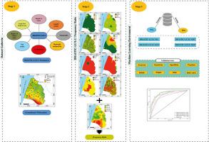
The Rmel aquifer, located in the Tangier-Tetouan-Al Hoceima region of northwest Morocco, covers approximately 240 km2 and faces increasing pollution threats due to population growth and economic development. This study assesses aquifer vulnerability to pollution, and compares the performance of various machine learning models integrated with the DRASTIC-LU/LC method. The research used a dataset of 52 water samples analyzed for nitrate concentrations, considering eight factors influencing vulnerability: aquifer depth, net recharge, aquifer lithology, soil texture, topography, vadose zone impact, hydraulic conductivity, and land use. An information gain test was applied to evaluate the importance of these factors. Four machine learning algorithms were used with the DRASTIC-LU/LC method: multilayer perceptron (MLP), the bagging algorithm (BA), K-nearest neighbors (KNN), and extremely randomized trees (ERT). Model performance was assessed via the area under the ROC curve (ROC-AUC) to measure accuracy. The ERT model combined with DRASTIC-LU/LC achieved the highest accuracy (AUC = 0.929), followed by BA (AUC = 0.925), MLP (AUC = 0.852), and KNN (AUC = 0.787). In comparison, the original DRASTIC-LU/LC model had an AUC of 0.530. The results highlight significant vulnerability variation across the Rmel aquifer, with high to very high levels in the southern and northwestern regions, and moderate to low levels in the northeast and central areas. Vulnerability maps were validated by comparing the observed nitrate concentrations in the water samples, confirming model accuracy. Groundwater depth, net recharge, and hydraulic conductivity were identified as the most significant factors influencing vulnerability. This study demonstrates the effectiveness of integrating machine learning models with the DRASTIC-LU/LC method for accurate aquifer vulnerability assessment, offering valuable tools for public policy and groundwater management.
期刊介绍:
Groundwater for Sustainable Development is directed to different stakeholders and professionals, including government and non-governmental organizations, international funding agencies, universities, public water institutions, public health and other public/private sector professionals, and other relevant institutions. It is aimed at professionals, academics and students in the fields of disciplines such as: groundwater and its connection to surface hydrology and environment, soil sciences, engineering, ecology, microbiology, atmospheric sciences, analytical chemistry, hydro-engineering, water technology, environmental ethics, economics, public health, policy, as well as social sciences, legal disciplines, or any other area connected with water issues. The objectives of this journal are to facilitate: • The improvement of effective and sustainable management of water resources across the globe. • The improvement of human access to groundwater resources in adequate quantity and good quality. • The meeting of the increasing demand for drinking and irrigation water needed for food security to contribute to a social and economically sound human development. • The creation of a global inter- and multidisciplinary platform and forum to improve our understanding of groundwater resources and to advocate their effective and sustainable management and protection against contamination. • Interdisciplinary information exchange and to stimulate scientific research in the fields of groundwater related sciences and social and health sciences required to achieve the United Nations Millennium Development Goals for sustainable development.