Valentina Romano, Federico Fischanger, Gary Wilson, Alessandra Sciarra, Adriano Mazzini, Claudio Mazzoli, Fabio Florindo, Maria Chiara Tartarello, Massimiliano Ascani, Jacob Anderson, Rachel Worthington, Richard Hardie, Bob Dagg, Livio Ruggiero
{"title":"南极泰勒谷的永久冻土水文地质学:深层电阻率层析成像的启示","authors":"Valentina Romano, Federico Fischanger, Gary Wilson, Alessandra Sciarra, Adriano Mazzini, Claudio Mazzoli, Fabio Florindo, Maria Chiara Tartarello, Massimiliano Ascani, Jacob Anderson, Rachel Worthington, Richard Hardie, Bob Dagg, Livio Ruggiero","doi":"10.1029/2023GL106912","DOIUrl":null,"url":null,"abstract":"<p>Global warming has prompted globally widespread permafrost thawing, resulting in enhanced greenhouse gas release into the atmosphere. Studies conducted in the Northern Hemisphere reveal an alarming increase in permafrost thawing. However, similar data from Antarctica are scarce. We conducted a 2-D Deep Electrical Resistivity Tomography (DERT) survey in Taylor Valley, Antarctica, to image the distribution of permafrost, its thicknesses, lower boundaries, and hydrogeology. Results show resistive, discontinuous domains that we suggest represent permafrost units. We also find highly conductive layers (5–10 Ω·m), between 300–350 m and 600–650 m below ground level and a shallower (∼50–100 m depth) conductive layer. The combined data set reveals a broad brine system in Taylor Valley, implying multi-tiered groundwater circulation: a shallow, localized system linked with surface water bodies and a separate deeper, regional circulation system. The arrangement of these brines across different levels, coupled with the uneven permafrost distribution, underscores potential interplay between the two systems.</p>","PeriodicalId":12523,"journal":{"name":"Geophysical Research Letters","volume":"51 18","pages":""},"PeriodicalIF":4.6000,"publicationDate":"2024-09-16","publicationTypes":"Journal Article","fieldsOfStudy":null,"isOpenAccess":false,"openAccessPdf":"https://onlinelibrary.wiley.com/doi/epdf/10.1029/2023GL106912","citationCount":"0","resultStr":"{\"title\":\"Permafrost Hydrogeology of Taylor Valley, Antarctica: Insights From Deep Electrical Resistivity Tomography\",\"authors\":\"Valentina Romano, Federico Fischanger, Gary Wilson, Alessandra Sciarra, Adriano Mazzini, Claudio Mazzoli, Fabio Florindo, Maria Chiara Tartarello, Massimiliano Ascani, Jacob Anderson, Rachel Worthington, Richard Hardie, Bob Dagg, Livio Ruggiero\",\"doi\":\"10.1029/2023GL106912\",\"DOIUrl\":null,\"url\":null,\"abstract\":\"<p>Global warming has prompted globally widespread permafrost thawing, resulting in enhanced greenhouse gas release into the atmosphere. Studies conducted in the Northern Hemisphere reveal an alarming increase in permafrost thawing. However, similar data from Antarctica are scarce. We conducted a 2-D Deep Electrical Resistivity Tomography (DERT) survey in Taylor Valley, Antarctica, to image the distribution of permafrost, its thicknesses, lower boundaries, and hydrogeology. Results show resistive, discontinuous domains that we suggest represent permafrost units. We also find highly conductive layers (5–10 Ω·m), between 300–350 m and 600–650 m below ground level and a shallower (∼50–100 m depth) conductive layer. The combined data set reveals a broad brine system in Taylor Valley, implying multi-tiered groundwater circulation: a shallow, localized system linked with surface water bodies and a separate deeper, regional circulation system. The arrangement of these brines across different levels, coupled with the uneven permafrost distribution, underscores potential interplay between the two systems.</p>\",\"PeriodicalId\":12523,\"journal\":{\"name\":\"Geophysical Research Letters\",\"volume\":\"51 18\",\"pages\":\"\"},\"PeriodicalIF\":4.6000,\"publicationDate\":\"2024-09-16\",\"publicationTypes\":\"Journal Article\",\"fieldsOfStudy\":null,\"isOpenAccess\":false,\"openAccessPdf\":\"https://onlinelibrary.wiley.com/doi/epdf/10.1029/2023GL106912\",\"citationCount\":\"0\",\"resultStr\":null,\"platform\":\"Semanticscholar\",\"paperid\":null,\"PeriodicalName\":\"Geophysical Research Letters\",\"FirstCategoryId\":\"89\",\"ListUrlMain\":\"https://onlinelibrary.wiley.com/doi/10.1029/2023GL106912\",\"RegionNum\":1,\"RegionCategory\":\"地球科学\",\"ArticlePicture\":[],\"TitleCN\":null,\"AbstractTextCN\":null,\"PMCID\":null,\"EPubDate\":\"\",\"PubModel\":\"\",\"JCR\":\"Q1\",\"JCRName\":\"GEOSCIENCES, MULTIDISCIPLINARY\",\"Score\":null,\"Total\":0}","platform":"Semanticscholar","paperid":null,"PeriodicalName":"Geophysical Research Letters","FirstCategoryId":"89","ListUrlMain":"https://onlinelibrary.wiley.com/doi/10.1029/2023GL106912","RegionNum":1,"RegionCategory":"地球科学","ArticlePicture":[],"TitleCN":null,"AbstractTextCN":null,"PMCID":null,"EPubDate":"","PubModel":"","JCR":"Q1","JCRName":"GEOSCIENCES, MULTIDISCIPLINARY","Score":null,"Total":0}
Permafrost Hydrogeology of Taylor Valley, Antarctica: Insights From Deep Electrical Resistivity Tomography
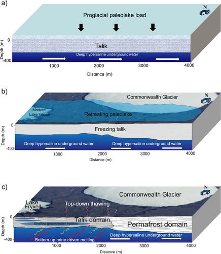
Global warming has prompted globally widespread permafrost thawing, resulting in enhanced greenhouse gas release into the atmosphere. Studies conducted in the Northern Hemisphere reveal an alarming increase in permafrost thawing. However, similar data from Antarctica are scarce. We conducted a 2-D Deep Electrical Resistivity Tomography (DERT) survey in Taylor Valley, Antarctica, to image the distribution of permafrost, its thicknesses, lower boundaries, and hydrogeology. Results show resistive, discontinuous domains that we suggest represent permafrost units. We also find highly conductive layers (5–10 Ω·m), between 300–350 m and 600–650 m below ground level and a shallower (∼50–100 m depth) conductive layer. The combined data set reveals a broad brine system in Taylor Valley, implying multi-tiered groundwater circulation: a shallow, localized system linked with surface water bodies and a separate deeper, regional circulation system. The arrangement of these brines across different levels, coupled with the uneven permafrost distribution, underscores potential interplay between the two systems.
期刊介绍:
Geophysical Research Letters (GRL) publishes high-impact, innovative, and timely research on major scientific advances in all the major geoscience disciplines. Papers are communications-length articles and should have broad and immediate implications in their discipline or across the geosciences. GRLmaintains the fastest turn-around of all high-impact publications in the geosciences and works closely with authors to ensure broad visibility of top papers.
 求助内容:
求助内容: 应助结果提醒方式:


