{"title":"将土壤侵蚀和沉积物迁移过程与可变渗透能力模型(VIC-SED)耦合起来,以满足粗时空分辨率的应用需求","authors":"Xianhong Xie, Xu Liang","doi":"10.1029/2024MS004307","DOIUrl":null,"url":null,"abstract":"<p>Understanding soil erosion and sediment transport from the hillslope scale to the regional scale is crucial for studies on water quality, soil-water conservation, the lateral carbon cycle, environmental zoning and vulnerability. However, most existing erosion and sediment transport models are only applicable at the hillslope scale or for small watersheds with fine spatial resolutions (typically much less than 1 km). This study presents a process-based soil erosion and sediment transport model for model applications designed for applications with coarse spatial (e.g., ≥10 km) and temporal (e.g., from hourly to daily) resolutions. This new model, referred to as VIC-SED, effectively accounts for interactions between erosion and hydrological processes. This is achieved by tightly coupling the erosion processes with a hydrologically based Three-layer Variable Infiltration Capacity (VIC-3L) land surface model (LSM) and to a multi-scale routing (MSR) model. VIC-SED considers the impacts of (a) the spatio-temporal variability of rainfall intensity on erosion processes and (b) soil moisture on the soil detachment process. VIC-SED is evaluated in two watersheds. Results demonstrate that VIC-SED is capable of reproducing water and suspended sediment discharges at coarse spatial resolutions and varying temporal scales varying from 15-min to daily intervals. Our study indicates that the VIC-SED model is a promising tool for studying and assessing the impacts of climate and land cover changes on suspended sediment yields over large regions using coarse spatial and temporal resolutions.</p>","PeriodicalId":14881,"journal":{"name":"Journal of Advances in Modeling Earth Systems","volume":"16 9","pages":""},"PeriodicalIF":4.4000,"publicationDate":"2024-09-14","publicationTypes":"Journal Article","fieldsOfStudy":null,"isOpenAccess":false,"openAccessPdf":"https://onlinelibrary.wiley.com/doi/epdf/10.1029/2024MS004307","citationCount":"0","resultStr":"{\"title\":\"Coupling Soil Erosion and Sediment Transport Processes With the Variable Infiltration Capacity Model (VIC-SED) for Applications Suitable With Coarse Spatial and Temporal Resolutions\",\"authors\":\"Xianhong Xie, Xu Liang\",\"doi\":\"10.1029/2024MS004307\",\"DOIUrl\":null,\"url\":null,\"abstract\":\"<p>Understanding soil erosion and sediment transport from the hillslope scale to the regional scale is crucial for studies on water quality, soil-water conservation, the lateral carbon cycle, environmental zoning and vulnerability. However, most existing erosion and sediment transport models are only applicable at the hillslope scale or for small watersheds with fine spatial resolutions (typically much less than 1 km). This study presents a process-based soil erosion and sediment transport model for model applications designed for applications with coarse spatial (e.g., ≥10 km) and temporal (e.g., from hourly to daily) resolutions. This new model, referred to as VIC-SED, effectively accounts for interactions between erosion and hydrological processes. This is achieved by tightly coupling the erosion processes with a hydrologically based Three-layer Variable Infiltration Capacity (VIC-3L) land surface model (LSM) and to a multi-scale routing (MSR) model. VIC-SED considers the impacts of (a) the spatio-temporal variability of rainfall intensity on erosion processes and (b) soil moisture on the soil detachment process. VIC-SED is evaluated in two watersheds. Results demonstrate that VIC-SED is capable of reproducing water and suspended sediment discharges at coarse spatial resolutions and varying temporal scales varying from 15-min to daily intervals. Our study indicates that the VIC-SED model is a promising tool for studying and assessing the impacts of climate and land cover changes on suspended sediment yields over large regions using coarse spatial and temporal resolutions.</p>\",\"PeriodicalId\":14881,\"journal\":{\"name\":\"Journal of Advances in Modeling Earth Systems\",\"volume\":\"16 9\",\"pages\":\"\"},\"PeriodicalIF\":4.4000,\"publicationDate\":\"2024-09-14\",\"publicationTypes\":\"Journal Article\",\"fieldsOfStudy\":null,\"isOpenAccess\":false,\"openAccessPdf\":\"https://onlinelibrary.wiley.com/doi/epdf/10.1029/2024MS004307\",\"citationCount\":\"0\",\"resultStr\":null,\"platform\":\"Semanticscholar\",\"paperid\":null,\"PeriodicalName\":\"Journal of Advances in Modeling Earth Systems\",\"FirstCategoryId\":\"89\",\"ListUrlMain\":\"https://onlinelibrary.wiley.com/doi/10.1029/2024MS004307\",\"RegionNum\":2,\"RegionCategory\":\"地球科学\",\"ArticlePicture\":[],\"TitleCN\":null,\"AbstractTextCN\":null,\"PMCID\":null,\"EPubDate\":\"\",\"PubModel\":\"\",\"JCR\":\"Q1\",\"JCRName\":\"METEOROLOGY & ATMOSPHERIC SCIENCES\",\"Score\":null,\"Total\":0}","platform":"Semanticscholar","paperid":null,"PeriodicalName":"Journal of Advances in Modeling Earth Systems","FirstCategoryId":"89","ListUrlMain":"https://onlinelibrary.wiley.com/doi/10.1029/2024MS004307","RegionNum":2,"RegionCategory":"地球科学","ArticlePicture":[],"TitleCN":null,"AbstractTextCN":null,"PMCID":null,"EPubDate":"","PubModel":"","JCR":"Q1","JCRName":"METEOROLOGY & ATMOSPHERIC SCIENCES","Score":null,"Total":0}
Coupling Soil Erosion and Sediment Transport Processes With the Variable Infiltration Capacity Model (VIC-SED) for Applications Suitable With Coarse Spatial and Temporal Resolutions
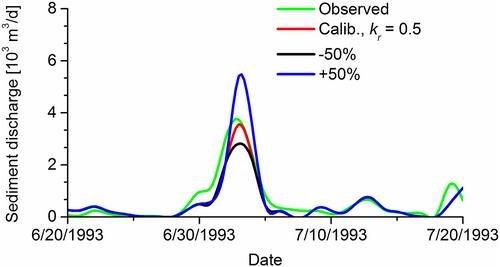
Understanding soil erosion and sediment transport from the hillslope scale to the regional scale is crucial for studies on water quality, soil-water conservation, the lateral carbon cycle, environmental zoning and vulnerability. However, most existing erosion and sediment transport models are only applicable at the hillslope scale or for small watersheds with fine spatial resolutions (typically much less than 1 km). This study presents a process-based soil erosion and sediment transport model for model applications designed for applications with coarse spatial (e.g., ≥10 km) and temporal (e.g., from hourly to daily) resolutions. This new model, referred to as VIC-SED, effectively accounts for interactions between erosion and hydrological processes. This is achieved by tightly coupling the erosion processes with a hydrologically based Three-layer Variable Infiltration Capacity (VIC-3L) land surface model (LSM) and to a multi-scale routing (MSR) model. VIC-SED considers the impacts of (a) the spatio-temporal variability of rainfall intensity on erosion processes and (b) soil moisture on the soil detachment process. VIC-SED is evaluated in two watersheds. Results demonstrate that VIC-SED is capable of reproducing water and suspended sediment discharges at coarse spatial resolutions and varying temporal scales varying from 15-min to daily intervals. Our study indicates that the VIC-SED model is a promising tool for studying and assessing the impacts of climate and land cover changes on suspended sediment yields over large regions using coarse spatial and temporal resolutions.
期刊介绍:
The Journal of Advances in Modeling Earth Systems (JAMES) is committed to advancing the science of Earth systems modeling by offering high-quality scientific research through online availability and open access licensing. JAMES invites authors and readers from the international Earth systems modeling community.
Open access. Articles are available free of charge for everyone with Internet access to view and download.
Formal peer review.
Supplemental material, such as code samples, images, and visualizations, is published at no additional charge.
No additional charge for color figures.
Modest page charges to cover production costs.
Articles published in high-quality full text PDF, HTML, and XML.
Internal and external reference linking, DOI registration, and forward linking via CrossRef.
 求助内容:
求助内容: 应助结果提醒方式:


