{"title":"基于深度学习图像分割的大尺度岩溶地区石漠化严重程度识别与因子分析","authors":"","doi":"10.1016/j.ecolind.2024.112565","DOIUrl":null,"url":null,"abstract":"<div><p>Land rocky desertification (RD) is one of the most serious environmental disasters in karst landforms. Identifying the rocky desertification severity level (RDSL) is a key task in the prevention and control projects of rocky desertification in karst areas. How to efficiently and accurately identify the RDSL is an urgent issue. It requires higher accuracy and more advanced techniques. Currently, machine learning-based remote sensing technology (RST) faces challenges in identifying the RDSL, including insufficient dataset features, low accuracy of identification models, and incomplete exploration of rocky desertification driving factors. To address these issues, this study leverages multi-source remote sensing satellite data and related product data to construct a multidimensional dataset with feature factors. By combining convolutional neural networks (CNN) and graph neural networks (GNN), a graph convolutional network segmentation model based on deep learning image segmentation is proposed for the automatic identification of RDSL. In addition, the study has investigated the spatiotemporal changes of RD in Guizhou Province in recent years and explored the impacts of various natural driving factors on the RDSLs. The experimental results indicate that the multidimensional feature dataset (Dataset-2) contributes to enhancing the identification accuracy of the model. The proposed model has capabilities such as composite representation in non-Euclidean space, deep extraction of image semantics, and multiscale segmentation and fusion. The model achieves an Mean Intersection over Union (MIoU) of 84.724, which outperforms other mainstream image segmentation methods. Although rocky desertification from 2015 to 2022 in Guizhou Province is significantly distributed, there is a trend toward mitigation. This study provides effective technical tools and data support for exploring the evolution process of desertification in subtropical karst areas, as well as for the implementation of projects related to environmental protection, afforestation, soil and water conservation, and land monitoring.</p></div>","PeriodicalId":11459,"journal":{"name":"Ecological Indicators","volume":null,"pages":null},"PeriodicalIF":7.0000,"publicationDate":"2024-09-14","publicationTypes":"Journal Article","fieldsOfStudy":null,"isOpenAccess":false,"openAccessPdf":"https://www.sciencedirect.com/science/article/pii/S1470160X24010227/pdfft?md5=34fff5a949f60056dedd4fa964234378&pid=1-s2.0-S1470160X24010227-main.pdf","citationCount":"0","resultStr":"{\"title\":\"Identification and factor analysis of rocky desertification severity levels in large-scale karst areas based on deep learning image segmentation\",\"authors\":\"\",\"doi\":\"10.1016/j.ecolind.2024.112565\",\"DOIUrl\":null,\"url\":null,\"abstract\":\"<div><p>Land rocky desertification (RD) is one of the most serious environmental disasters in karst landforms. Identifying the rocky desertification severity level (RDSL) is a key task in the prevention and control projects of rocky desertification in karst areas. How to efficiently and accurately identify the RDSL is an urgent issue. It requires higher accuracy and more advanced techniques. Currently, machine learning-based remote sensing technology (RST) faces challenges in identifying the RDSL, including insufficient dataset features, low accuracy of identification models, and incomplete exploration of rocky desertification driving factors. To address these issues, this study leverages multi-source remote sensing satellite data and related product data to construct a multidimensional dataset with feature factors. By combining convolutional neural networks (CNN) and graph neural networks (GNN), a graph convolutional network segmentation model based on deep learning image segmentation is proposed for the automatic identification of RDSL. In addition, the study has investigated the spatiotemporal changes of RD in Guizhou Province in recent years and explored the impacts of various natural driving factors on the RDSLs. The experimental results indicate that the multidimensional feature dataset (Dataset-2) contributes to enhancing the identification accuracy of the model. The proposed model has capabilities such as composite representation in non-Euclidean space, deep extraction of image semantics, and multiscale segmentation and fusion. The model achieves an Mean Intersection over Union (MIoU) of 84.724, which outperforms other mainstream image segmentation methods. Although rocky desertification from 2015 to 2022 in Guizhou Province is significantly distributed, there is a trend toward mitigation. This study provides effective technical tools and data support for exploring the evolution process of desertification in subtropical karst areas, as well as for the implementation of projects related to environmental protection, afforestation, soil and water conservation, and land monitoring.</p></div>\",\"PeriodicalId\":11459,\"journal\":{\"name\":\"Ecological Indicators\",\"volume\":null,\"pages\":null},\"PeriodicalIF\":7.0000,\"publicationDate\":\"2024-09-14\",\"publicationTypes\":\"Journal Article\",\"fieldsOfStudy\":null,\"isOpenAccess\":false,\"openAccessPdf\":\"https://www.sciencedirect.com/science/article/pii/S1470160X24010227/pdfft?md5=34fff5a949f60056dedd4fa964234378&pid=1-s2.0-S1470160X24010227-main.pdf\",\"citationCount\":\"0\",\"resultStr\":null,\"platform\":\"Semanticscholar\",\"paperid\":null,\"PeriodicalName\":\"Ecological Indicators\",\"FirstCategoryId\":\"93\",\"ListUrlMain\":\"https://www.sciencedirect.com/science/article/pii/S1470160X24010227\",\"RegionNum\":2,\"RegionCategory\":\"环境科学与生态学\",\"ArticlePicture\":[],\"TitleCN\":null,\"AbstractTextCN\":null,\"PMCID\":null,\"EPubDate\":\"\",\"PubModel\":\"\",\"JCR\":\"Q1\",\"JCRName\":\"ENVIRONMENTAL SCIENCES\",\"Score\":null,\"Total\":0}","platform":"Semanticscholar","paperid":null,"PeriodicalName":"Ecological Indicators","FirstCategoryId":"93","ListUrlMain":"https://www.sciencedirect.com/science/article/pii/S1470160X24010227","RegionNum":2,"RegionCategory":"环境科学与生态学","ArticlePicture":[],"TitleCN":null,"AbstractTextCN":null,"PMCID":null,"EPubDate":"","PubModel":"","JCR":"Q1","JCRName":"ENVIRONMENTAL SCIENCES","Score":null,"Total":0}
Identification and factor analysis of rocky desertification severity levels in large-scale karst areas based on deep learning image segmentation
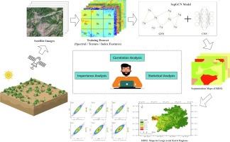
Land rocky desertification (RD) is one of the most serious environmental disasters in karst landforms. Identifying the rocky desertification severity level (RDSL) is a key task in the prevention and control projects of rocky desertification in karst areas. How to efficiently and accurately identify the RDSL is an urgent issue. It requires higher accuracy and more advanced techniques. Currently, machine learning-based remote sensing technology (RST) faces challenges in identifying the RDSL, including insufficient dataset features, low accuracy of identification models, and incomplete exploration of rocky desertification driving factors. To address these issues, this study leverages multi-source remote sensing satellite data and related product data to construct a multidimensional dataset with feature factors. By combining convolutional neural networks (CNN) and graph neural networks (GNN), a graph convolutional network segmentation model based on deep learning image segmentation is proposed for the automatic identification of RDSL. In addition, the study has investigated the spatiotemporal changes of RD in Guizhou Province in recent years and explored the impacts of various natural driving factors on the RDSLs. The experimental results indicate that the multidimensional feature dataset (Dataset-2) contributes to enhancing the identification accuracy of the model. The proposed model has capabilities such as composite representation in non-Euclidean space, deep extraction of image semantics, and multiscale segmentation and fusion. The model achieves an Mean Intersection over Union (MIoU) of 84.724, which outperforms other mainstream image segmentation methods. Although rocky desertification from 2015 to 2022 in Guizhou Province is significantly distributed, there is a trend toward mitigation. This study provides effective technical tools and data support for exploring the evolution process of desertification in subtropical karst areas, as well as for the implementation of projects related to environmental protection, afforestation, soil and water conservation, and land monitoring.
期刊介绍:
The ultimate aim of Ecological Indicators is to integrate the monitoring and assessment of ecological and environmental indicators with management practices. The journal provides a forum for the discussion of the applied scientific development and review of traditional indicator approaches as well as for theoretical, modelling and quantitative applications such as index development. Research into the following areas will be published.
• All aspects of ecological and environmental indicators and indices.
• New indicators, and new approaches and methods for indicator development, testing and use.
• Development and modelling of indices, e.g. application of indicator suites across multiple scales and resources.
• Analysis and research of resource, system- and scale-specific indicators.
• Methods for integration of social and other valuation metrics for the production of scientifically rigorous and politically-relevant assessments using indicator-based monitoring and assessment programs.
• How research indicators can be transformed into direct application for management purposes.
• Broader assessment objectives and methods, e.g. biodiversity, biological integrity, and sustainability, through the use of indicators.
• Resource-specific indicators such as landscape, agroecosystems, forests, wetlands, etc.

 求助内容:
求助内容: 应助结果提醒方式:


