{"title":"利用遥感估测植物生长和确定需水量的新方法","authors":"A. A. Baradaran, M. S. Tavazoei","doi":"10.1007/s13762-024-06020-w","DOIUrl":null,"url":null,"abstract":"<div><p>Due to different climatic conditions and the high cost of devices, monitoring plant growth is complex and costly. Remote sensing of agricultural lands on a large scale using satellite imagery is more appropriate than hardware equipment such as sensors. One of the main challenges in plant growth is the rate of plant evapotranspiration discussed in the FAO-56 paper. The rate of plant evapotranspiration in the initial, development, and late growth stages is an important issue. Factors such as irrigation method, surface albedo, height above sea level, aerodynamic conditions, leaf and stomata, and soil texture are main to review plant growth from placement to harvest. In this research using Landsat 8 satellite imagery and vegetation indices, we present an approach in which exist several important indicators for sensing plant growth, determining soil texture and moisture, land slope, and improving cloud effects. The water required by the plant at different stages of growth and the equations in the FAO-56 paper estimate and improve using these indices. We have used cubic spline interpolation, Pearson correlation coefficient, explanation coefficient (R<sup>2</sup>), Root Mean Square Error (RMSE), Mean Absolute Deviation (MAD), and the Mean Standard Error (MSE) to evaluate and compare the accuracy of each index. Finally, the correlation equation of each index is calculated with its actual values. We have also used hypothesis and regression analysis testing to prove efficiency and predict crop behavior.</p><p>The results show that the proposed approach by evaluating spatial and temporal data in different climates leads to greater efficiency and crop. The study can consider important parameters in precision agriculture to achieve efficiency, productivity, quality, profitability, and sustainability of crops.</p><h3>Graphical Abstract</h3><div><figure><div><div><picture><source><img></source></picture></div></div></figure></div></div>","PeriodicalId":589,"journal":{"name":"International Journal of Environmental Science and Technology","volume":"22 5","pages":"3419 - 3450"},"PeriodicalIF":3.0000,"publicationDate":"2024-09-10","publicationTypes":"Journal Article","fieldsOfStudy":null,"isOpenAccess":false,"openAccessPdf":"","citationCount":"0","resultStr":"{\"title\":\"A new approach for estimating plant growth and determining water requirement using remote sensing\",\"authors\":\"A. A. Baradaran, M. S. Tavazoei\",\"doi\":\"10.1007/s13762-024-06020-w\",\"DOIUrl\":null,\"url\":null,\"abstract\":\"<div><p>Due to different climatic conditions and the high cost of devices, monitoring plant growth is complex and costly. Remote sensing of agricultural lands on a large scale using satellite imagery is more appropriate than hardware equipment such as sensors. One of the main challenges in plant growth is the rate of plant evapotranspiration discussed in the FAO-56 paper. The rate of plant evapotranspiration in the initial, development, and late growth stages is an important issue. Factors such as irrigation method, surface albedo, height above sea level, aerodynamic conditions, leaf and stomata, and soil texture are main to review plant growth from placement to harvest. In this research using Landsat 8 satellite imagery and vegetation indices, we present an approach in which exist several important indicators for sensing plant growth, determining soil texture and moisture, land slope, and improving cloud effects. The water required by the plant at different stages of growth and the equations in the FAO-56 paper estimate and improve using these indices. We have used cubic spline interpolation, Pearson correlation coefficient, explanation coefficient (R<sup>2</sup>), Root Mean Square Error (RMSE), Mean Absolute Deviation (MAD), and the Mean Standard Error (MSE) to evaluate and compare the accuracy of each index. Finally, the correlation equation of each index is calculated with its actual values. We have also used hypothesis and regression analysis testing to prove efficiency and predict crop behavior.</p><p>The results show that the proposed approach by evaluating spatial and temporal data in different climates leads to greater efficiency and crop. The study can consider important parameters in precision agriculture to achieve efficiency, productivity, quality, profitability, and sustainability of crops.</p><h3>Graphical Abstract</h3><div><figure><div><div><picture><source><img></source></picture></div></div></figure></div></div>\",\"PeriodicalId\":589,\"journal\":{\"name\":\"International Journal of Environmental Science and Technology\",\"volume\":\"22 5\",\"pages\":\"3419 - 3450\"},\"PeriodicalIF\":3.0000,\"publicationDate\":\"2024-09-10\",\"publicationTypes\":\"Journal Article\",\"fieldsOfStudy\":null,\"isOpenAccess\":false,\"openAccessPdf\":\"\",\"citationCount\":\"0\",\"resultStr\":null,\"platform\":\"Semanticscholar\",\"paperid\":null,\"PeriodicalName\":\"International Journal of Environmental Science and Technology\",\"FirstCategoryId\":\"93\",\"ListUrlMain\":\"https://link.springer.com/article/10.1007/s13762-024-06020-w\",\"RegionNum\":4,\"RegionCategory\":\"环境科学与生态学\",\"ArticlePicture\":[],\"TitleCN\":null,\"AbstractTextCN\":null,\"PMCID\":null,\"EPubDate\":\"\",\"PubModel\":\"\",\"JCR\":\"Q2\",\"JCRName\":\"ENVIRONMENTAL SCIENCES\",\"Score\":null,\"Total\":0}","platform":"Semanticscholar","paperid":null,"PeriodicalName":"International Journal of Environmental Science and Technology","FirstCategoryId":"93","ListUrlMain":"https://link.springer.com/article/10.1007/s13762-024-06020-w","RegionNum":4,"RegionCategory":"环境科学与生态学","ArticlePicture":[],"TitleCN":null,"AbstractTextCN":null,"PMCID":null,"EPubDate":"","PubModel":"","JCR":"Q2","JCRName":"ENVIRONMENTAL SCIENCES","Score":null,"Total":0}
A new approach for estimating plant growth and determining water requirement using remote sensing
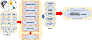
Due to different climatic conditions and the high cost of devices, monitoring plant growth is complex and costly. Remote sensing of agricultural lands on a large scale using satellite imagery is more appropriate than hardware equipment such as sensors. One of the main challenges in plant growth is the rate of plant evapotranspiration discussed in the FAO-56 paper. The rate of plant evapotranspiration in the initial, development, and late growth stages is an important issue. Factors such as irrigation method, surface albedo, height above sea level, aerodynamic conditions, leaf and stomata, and soil texture are main to review plant growth from placement to harvest. In this research using Landsat 8 satellite imagery and vegetation indices, we present an approach in which exist several important indicators for sensing plant growth, determining soil texture and moisture, land slope, and improving cloud effects. The water required by the plant at different stages of growth and the equations in the FAO-56 paper estimate and improve using these indices. We have used cubic spline interpolation, Pearson correlation coefficient, explanation coefficient (R2), Root Mean Square Error (RMSE), Mean Absolute Deviation (MAD), and the Mean Standard Error (MSE) to evaluate and compare the accuracy of each index. Finally, the correlation equation of each index is calculated with its actual values. We have also used hypothesis and regression analysis testing to prove efficiency and predict crop behavior.
The results show that the proposed approach by evaluating spatial and temporal data in different climates leads to greater efficiency and crop. The study can consider important parameters in precision agriculture to achieve efficiency, productivity, quality, profitability, and sustainability of crops.
期刊介绍:
International Journal of Environmental Science and Technology (IJEST) is an international scholarly refereed research journal which aims to promote the theory and practice of environmental science and technology, innovation, engineering and management.
A broad outline of the journal''s scope includes: peer reviewed original research articles, case and technical reports, reviews and analyses papers, short communications and notes to the editor, in interdisciplinary information on the practice and status of research in environmental science and technology, both natural and man made.
The main aspects of research areas include, but are not exclusive to; environmental chemistry and biology, environments pollution control and abatement technology, transport and fate of pollutants in the environment, concentrations and dispersion of wastes in air, water, and soil, point and non-point sources pollution, heavy metals and organic compounds in the environment, atmospheric pollutants and trace gases, solid and hazardous waste management; soil biodegradation and bioremediation of contaminated sites; environmental impact assessment, industrial ecology, ecological and human risk assessment; improved energy management and auditing efficiency and environmental standards and criteria.

 求助内容:
求助内容: 应助结果提醒方式:


