Jonathan M. Friedman, Anne C. Tillery, Samuel Alfieri, Elizabeth Skaggs, Patrick B. Shafroth, Craig D. Allen
{"title":"美国新墨西哥州杰米斯山严重野火和洪水后泥石流沉积物的重新分布","authors":"Jonathan M. Friedman, Anne C. Tillery, Samuel Alfieri, Elizabeth Skaggs, Patrick B. Shafroth, Craig D. Allen","doi":"10.1002/esp.5964","DOIUrl":null,"url":null,"abstract":"<p>Severe fire on steep slopes increases stormwater runoff and the occurrence of runoff-initiated debris flows. Predicting locations of debris flows and their downstream effects on trunk streams requires watershed-scale high-resolution topographic data. Intense precipitation in July and September 2013 following the June 2011 Las Conchas Fire in the Jemez Mountains, New Mexico, led to widespread debris flows in the watershed of Rito de los Frijoles. We differenced lidar Digital Elevation Models (DEMs) collected in 2010 and 2016 to map subwatersheds experiencing debris flows and changes in elevation of the trunk stream. Debris flow occurrence was well predicted by previous assessments of debris-flow hazard; debris flows occurred in 7 of 9 sub-basins where the debris-flow hazard was above 60% for the 25-year rainfall event, and in 0 of 21 basins where debris flow hazard was less than 60%. Debris flows resulted in fan deposition at the confluence with the trunk stream followed by transport during three documented floods. The bed of the 22 km trunk stream increased in elevation by a mean of 0.29 m, but the local change in thalweg elevation was controlled by inputs of water and sediment and longitudinal variation in gradient. Downstream of the mouths of tributaries with debris flows, the thalweg of the trunk stream rose as much as 2 m. Downstream of the mouths of tributaries without debris flows the thalweg of the main stem degraded by as much as 2 m, mobilizing sediment that was then deposited further downstream where the gradient of the trunk stream decreases. In conclusion, the transport of sediment generated by debris flows was predictably related to spatial variation in sediment supply, discharge and gradient.</p>","PeriodicalId":11408,"journal":{"name":"Earth Surface Processes and Landforms","volume":"49 13","pages":"4263-4274"},"PeriodicalIF":2.8000,"publicationDate":"2024-08-13","publicationTypes":"Journal Article","fieldsOfStudy":null,"isOpenAccess":false,"openAccessPdf":"","citationCount":"0","resultStr":"{\"title\":\"Redistribution of debris-flow sediment following severe wildfire and floods in the Jemez Mountains, New Mexico, USA\",\"authors\":\"Jonathan M. Friedman, Anne C. Tillery, Samuel Alfieri, Elizabeth Skaggs, Patrick B. Shafroth, Craig D. Allen\",\"doi\":\"10.1002/esp.5964\",\"DOIUrl\":null,\"url\":null,\"abstract\":\"<p>Severe fire on steep slopes increases stormwater runoff and the occurrence of runoff-initiated debris flows. Predicting locations of debris flows and their downstream effects on trunk streams requires watershed-scale high-resolution topographic data. Intense precipitation in July and September 2013 following the June 2011 Las Conchas Fire in the Jemez Mountains, New Mexico, led to widespread debris flows in the watershed of Rito de los Frijoles. We differenced lidar Digital Elevation Models (DEMs) collected in 2010 and 2016 to map subwatersheds experiencing debris flows and changes in elevation of the trunk stream. Debris flow occurrence was well predicted by previous assessments of debris-flow hazard; debris flows occurred in 7 of 9 sub-basins where the debris-flow hazard was above 60% for the 25-year rainfall event, and in 0 of 21 basins where debris flow hazard was less than 60%. Debris flows resulted in fan deposition at the confluence with the trunk stream followed by transport during three documented floods. The bed of the 22 km trunk stream increased in elevation by a mean of 0.29 m, but the local change in thalweg elevation was controlled by inputs of water and sediment and longitudinal variation in gradient. Downstream of the mouths of tributaries with debris flows, the thalweg of the trunk stream rose as much as 2 m. Downstream of the mouths of tributaries without debris flows the thalweg of the main stem degraded by as much as 2 m, mobilizing sediment that was then deposited further downstream where the gradient of the trunk stream decreases. In conclusion, the transport of sediment generated by debris flows was predictably related to spatial variation in sediment supply, discharge and gradient.</p>\",\"PeriodicalId\":11408,\"journal\":{\"name\":\"Earth Surface Processes and Landforms\",\"volume\":\"49 13\",\"pages\":\"4263-4274\"},\"PeriodicalIF\":2.8000,\"publicationDate\":\"2024-08-13\",\"publicationTypes\":\"Journal Article\",\"fieldsOfStudy\":null,\"isOpenAccess\":false,\"openAccessPdf\":\"\",\"citationCount\":\"0\",\"resultStr\":null,\"platform\":\"Semanticscholar\",\"paperid\":null,\"PeriodicalName\":\"Earth Surface Processes and Landforms\",\"FirstCategoryId\":\"89\",\"ListUrlMain\":\"https://onlinelibrary.wiley.com/doi/10.1002/esp.5964\",\"RegionNum\":3,\"RegionCategory\":\"地球科学\",\"ArticlePicture\":[],\"TitleCN\":null,\"AbstractTextCN\":null,\"PMCID\":null,\"EPubDate\":\"\",\"PubModel\":\"\",\"JCR\":\"Q2\",\"JCRName\":\"GEOGRAPHY, PHYSICAL\",\"Score\":null,\"Total\":0}","platform":"Semanticscholar","paperid":null,"PeriodicalName":"Earth Surface Processes and Landforms","FirstCategoryId":"89","ListUrlMain":"https://onlinelibrary.wiley.com/doi/10.1002/esp.5964","RegionNum":3,"RegionCategory":"地球科学","ArticlePicture":[],"TitleCN":null,"AbstractTextCN":null,"PMCID":null,"EPubDate":"","PubModel":"","JCR":"Q2","JCRName":"GEOGRAPHY, PHYSICAL","Score":null,"Total":0}
Redistribution of debris-flow sediment following severe wildfire and floods in the Jemez Mountains, New Mexico, USA
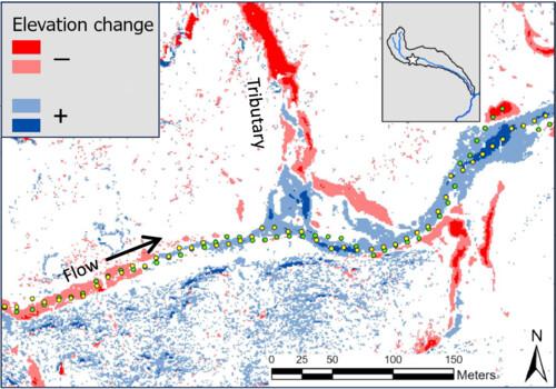
Severe fire on steep slopes increases stormwater runoff and the occurrence of runoff-initiated debris flows. Predicting locations of debris flows and their downstream effects on trunk streams requires watershed-scale high-resolution topographic data. Intense precipitation in July and September 2013 following the June 2011 Las Conchas Fire in the Jemez Mountains, New Mexico, led to widespread debris flows in the watershed of Rito de los Frijoles. We differenced lidar Digital Elevation Models (DEMs) collected in 2010 and 2016 to map subwatersheds experiencing debris flows and changes in elevation of the trunk stream. Debris flow occurrence was well predicted by previous assessments of debris-flow hazard; debris flows occurred in 7 of 9 sub-basins where the debris-flow hazard was above 60% for the 25-year rainfall event, and in 0 of 21 basins where debris flow hazard was less than 60%. Debris flows resulted in fan deposition at the confluence with the trunk stream followed by transport during three documented floods. The bed of the 22 km trunk stream increased in elevation by a mean of 0.29 m, but the local change in thalweg elevation was controlled by inputs of water and sediment and longitudinal variation in gradient. Downstream of the mouths of tributaries with debris flows, the thalweg of the trunk stream rose as much as 2 m. Downstream of the mouths of tributaries without debris flows the thalweg of the main stem degraded by as much as 2 m, mobilizing sediment that was then deposited further downstream where the gradient of the trunk stream decreases. In conclusion, the transport of sediment generated by debris flows was predictably related to spatial variation in sediment supply, discharge and gradient.
期刊介绍:
Earth Surface Processes and Landforms is an interdisciplinary international journal concerned with:
the interactions between surface processes and landforms and landscapes;
that lead to physical, chemical and biological changes; and which in turn create;
current landscapes and the geological record of past landscapes.
Its focus is core to both physical geographical and geological communities, and also the wider geosciences

 求助内容:
求助内容: 应助结果提醒方式:


