{"title":"利用树木年代学分析和电阻率断层扫描研究捷克共和国喀尔巴阡山脉飞沙岩深层滑坡的长期运动活动和内部结构","authors":"Jan Klimeš, Filip Hartvich, Karel Šilhán","doi":"10.1007/s10346-024-02330-9","DOIUrl":null,"url":null,"abstract":"<p>Complex or compound landslides, which combine different movement types with sliding planes at various depths and with varying movement acceleration frequencies, are highly demanding for landform mapping, movement monitoring and reliable hazard assessment. In this work, several techniques including dendrogeomorphological investigation were combined to describe surface morphology, underground structures and movement dynamics of the compound and deep-seated landslide aiming to provide reliable information for its hazard assessment. Interpretation of high-quality digital elevation model and detailed field morphological mapping along with geological information provided context for the interpretation of electric resistivity tomography profiles and enabled the description of properties of two distinct landforms, which are typically identified on a compound or complex deep-seated landslides in the studied region—shallow slides and landslide blocks. Dendrogeomorphological investigation proved for the first time the movement accelerations of the landslide blocks, which reactivate approximately half as often as shallow slides. It also showed different trees’ responses to the movements of these two landforms. Trees on the shallow landslide responded mainly with abrupt growth suppression (54.4%) to movements of its highly disturbed material. In contrast, trees on landslide blocks exhibited a dominant response (84.7%) with reaction wood to tilting of the landslide blocks composed of more coherent rock material. The research demonstrated that the dendrogeomorphological investigations provide reliable identification of years with accelerated movements, which corresponds well to instrumental, near-surface monitoring of the landslide. And at the same time, the method provided densely spatially distributed information about partial landslide reactivations during several decades in conditions (e.g. dense forests), where remote sensing methods are difficult to apply. Therefore, we argue that the dendrogeomorphological research is well applicable for hazard assessment of partial failures (cf., shallow slides and landslide blocks) of compound or complex landslides providing information also about the type of landslide movements (sliding vs. surface tilting) and character of the deformed material (highly disturbed vs. more coherent).</p>","PeriodicalId":17938,"journal":{"name":"Landslides","volume":"27 1","pages":""},"PeriodicalIF":7.0000,"publicationDate":"2024-08-16","publicationTypes":"Journal Article","fieldsOfStudy":null,"isOpenAccess":false,"openAccessPdf":"","citationCount":"0","resultStr":"{\"title\":\"Long-term movement activity and internal structure of deep-seated landslide by using dendrochronology analysis and electric resistivity tomography in flysch rocks, Carpathians, Czech Republic\",\"authors\":\"Jan Klimeš, Filip Hartvich, Karel Šilhán\",\"doi\":\"10.1007/s10346-024-02330-9\",\"DOIUrl\":null,\"url\":null,\"abstract\":\"<p>Complex or compound landslides, which combine different movement types with sliding planes at various depths and with varying movement acceleration frequencies, are highly demanding for landform mapping, movement monitoring and reliable hazard assessment. In this work, several techniques including dendrogeomorphological investigation were combined to describe surface morphology, underground structures and movement dynamics of the compound and deep-seated landslide aiming to provide reliable information for its hazard assessment. Interpretation of high-quality digital elevation model and detailed field morphological mapping along with geological information provided context for the interpretation of electric resistivity tomography profiles and enabled the description of properties of two distinct landforms, which are typically identified on a compound or complex deep-seated landslides in the studied region—shallow slides and landslide blocks. Dendrogeomorphological investigation proved for the first time the movement accelerations of the landslide blocks, which reactivate approximately half as often as shallow slides. It also showed different trees’ responses to the movements of these two landforms. Trees on the shallow landslide responded mainly with abrupt growth suppression (54.4%) to movements of its highly disturbed material. In contrast, trees on landslide blocks exhibited a dominant response (84.7%) with reaction wood to tilting of the landslide blocks composed of more coherent rock material. The research demonstrated that the dendrogeomorphological investigations provide reliable identification of years with accelerated movements, which corresponds well to instrumental, near-surface monitoring of the landslide. And at the same time, the method provided densely spatially distributed information about partial landslide reactivations during several decades in conditions (e.g. dense forests), where remote sensing methods are difficult to apply. Therefore, we argue that the dendrogeomorphological research is well applicable for hazard assessment of partial failures (cf., shallow slides and landslide blocks) of compound or complex landslides providing information also about the type of landslide movements (sliding vs. surface tilting) and character of the deformed material (highly disturbed vs. more coherent).</p>\",\"PeriodicalId\":17938,\"journal\":{\"name\":\"Landslides\",\"volume\":\"27 1\",\"pages\":\"\"},\"PeriodicalIF\":7.0000,\"publicationDate\":\"2024-08-16\",\"publicationTypes\":\"Journal Article\",\"fieldsOfStudy\":null,\"isOpenAccess\":false,\"openAccessPdf\":\"\",\"citationCount\":\"0\",\"resultStr\":null,\"platform\":\"Semanticscholar\",\"paperid\":null,\"PeriodicalName\":\"Landslides\",\"FirstCategoryId\":\"89\",\"ListUrlMain\":\"https://doi.org/10.1007/s10346-024-02330-9\",\"RegionNum\":2,\"RegionCategory\":\"工程技术\",\"ArticlePicture\":[],\"TitleCN\":null,\"AbstractTextCN\":null,\"PMCID\":null,\"EPubDate\":\"\",\"PubModel\":\"\",\"JCR\":\"Q1\",\"JCRName\":\"ENGINEERING, GEOLOGICAL\",\"Score\":null,\"Total\":0}","platform":"Semanticscholar","paperid":null,"PeriodicalName":"Landslides","FirstCategoryId":"89","ListUrlMain":"https://doi.org/10.1007/s10346-024-02330-9","RegionNum":2,"RegionCategory":"工程技术","ArticlePicture":[],"TitleCN":null,"AbstractTextCN":null,"PMCID":null,"EPubDate":"","PubModel":"","JCR":"Q1","JCRName":"ENGINEERING, GEOLOGICAL","Score":null,"Total":0}
Long-term movement activity and internal structure of deep-seated landslide by using dendrochronology analysis and electric resistivity tomography in flysch rocks, Carpathians, Czech Republic
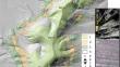
Complex or compound landslides, which combine different movement types with sliding planes at various depths and with varying movement acceleration frequencies, are highly demanding for landform mapping, movement monitoring and reliable hazard assessment. In this work, several techniques including dendrogeomorphological investigation were combined to describe surface morphology, underground structures and movement dynamics of the compound and deep-seated landslide aiming to provide reliable information for its hazard assessment. Interpretation of high-quality digital elevation model and detailed field morphological mapping along with geological information provided context for the interpretation of electric resistivity tomography profiles and enabled the description of properties of two distinct landforms, which are typically identified on a compound or complex deep-seated landslides in the studied region—shallow slides and landslide blocks. Dendrogeomorphological investigation proved for the first time the movement accelerations of the landslide blocks, which reactivate approximately half as often as shallow slides. It also showed different trees’ responses to the movements of these two landforms. Trees on the shallow landslide responded mainly with abrupt growth suppression (54.4%) to movements of its highly disturbed material. In contrast, trees on landslide blocks exhibited a dominant response (84.7%) with reaction wood to tilting of the landslide blocks composed of more coherent rock material. The research demonstrated that the dendrogeomorphological investigations provide reliable identification of years with accelerated movements, which corresponds well to instrumental, near-surface monitoring of the landslide. And at the same time, the method provided densely spatially distributed information about partial landslide reactivations during several decades in conditions (e.g. dense forests), where remote sensing methods are difficult to apply. Therefore, we argue that the dendrogeomorphological research is well applicable for hazard assessment of partial failures (cf., shallow slides and landslide blocks) of compound or complex landslides providing information also about the type of landslide movements (sliding vs. surface tilting) and character of the deformed material (highly disturbed vs. more coherent).
期刊介绍:
Landslides are gravitational mass movements of rock, debris or earth. They may occur in conjunction with other major natural disasters such as floods, earthquakes and volcanic eruptions. Expanding urbanization and changing land-use practices have increased the incidence of landslide disasters. Landslides as catastrophic events include human injury, loss of life and economic devastation and are studied as part of the fields of earth, water and engineering sciences. The aim of the journal Landslides is to be the common platform for the publication of integrated research on landslide processes, hazards, risk analysis, mitigation, and the protection of our cultural heritage and the environment. The journal publishes research papers, news of recent landslide events and information on the activities of the International Consortium on Landslides.
- Landslide dynamics, mechanisms and processes
- Landslide risk evaluation: hazard assessment, hazard mapping, and vulnerability assessment
- Geological, Geotechnical, Hydrological and Geophysical modeling
- Effects of meteorological, hydrological and global climatic change factors
- Monitoring including remote sensing and other non-invasive systems
- New technology, expert and intelligent systems
- Application of GIS techniques
- Rock slides, rock falls, debris flows, earth flows, and lateral spreads
- Large-scale landslides, lahars and pyroclastic flows in volcanic zones
- Marine and reservoir related landslides
- Landslide related tsunamis and seiches
- Landslide disasters in urban areas and along critical infrastructure
- Landslides and natural resources
- Land development and land-use practices
- Landslide remedial measures / prevention works
- Temporal and spatial prediction of landslides
- Early warning and evacuation
- Global landslide database
 求助内容:
求助内容: 应助结果提醒方式:


