Muhammad Tayyib Riaz, Muhammad Basharat, Khawaja Shoaib Ahmed, Yasir Sirfraz, Amir Shahzad, Nisar Ali Shah
{"title":"巴基斯坦北部由降雨引发的大规模断层控制滑坡的破坏机理","authors":"Muhammad Tayyib Riaz, Muhammad Basharat, Khawaja Shoaib Ahmed, Yasir Sirfraz, Amir Shahzad, Nisar Ali Shah","doi":"10.1007/s10346-024-02342-5","DOIUrl":null,"url":null,"abstract":"<p>A massive landslide occurred in Domeshi area, District Muzaffarabad, Pakistan, in two distinct phases: an initial movement on August 1, followed by complete failure on August 4, 2023. The landslide movement persisted for 96 h, with a runout distance of 500 m. The event destroyed numerous residential structures, impacting multiple families, and causing extensive damage to cultivated land and road infrastructure. To comprehensively understand the failure mechanisms, a detailed study was undertaken, encompassing site investigations, unmanned aerial vehicle (UAV) photography, geotechnical and geophysical investigations, petrographic analysis, kinematics, and numerical simulations. The field evidence indicates that the active deformation along the Jhelum Fault (JF) within the landslide’s main body weakened the surrounding rock formations. Intense rainfall saturated pre-existing fractures, creating critical zones of weakness. Highly plastic clays along fault plane contributed significantly to volume changes, especially during and after rainfall events. Kinematic analysis identified bedding joints as prevalent failure planes for planar sliding. Geophysical survey revealed a layer of unconsolidated material extending 25–30 m below the landslide’s scarp, accompanied by various fractures, including a deep fracture (i.e., JF) up to 300 m depth. Petrographic investigations showed microfractures, micro faults, and intragranular mineral breakage, indicative of intense tectonic stresses. Slope stability analysis indicated factors of safety (FoS) and strength reduction factor (SRF) less than 1, suggesting the potential for further failure in the lower sections of the landslide. Multiple factors, including slope geometry, active tectonics, material composition, and anthropogenic factors (i.e., slope loading and cutting for road and building construction, improper drainage distribution), contributed to the landslide's occurrence, however, the rainfall emerged as the primary triggering event.</p>","PeriodicalId":17938,"journal":{"name":"Landslides","volume":"43 1","pages":""},"PeriodicalIF":7.0000,"publicationDate":"2024-08-19","publicationTypes":"Journal Article","fieldsOfStudy":null,"isOpenAccess":false,"openAccessPdf":"","citationCount":"0","resultStr":"{\"title\":\"Failure mechanism of a massive fault–controlled rainfall–triggered landslide in northern Pakistan\",\"authors\":\"Muhammad Tayyib Riaz, Muhammad Basharat, Khawaja Shoaib Ahmed, Yasir Sirfraz, Amir Shahzad, Nisar Ali Shah\",\"doi\":\"10.1007/s10346-024-02342-5\",\"DOIUrl\":null,\"url\":null,\"abstract\":\"<p>A massive landslide occurred in Domeshi area, District Muzaffarabad, Pakistan, in two distinct phases: an initial movement on August 1, followed by complete failure on August 4, 2023. The landslide movement persisted for 96 h, with a runout distance of 500 m. The event destroyed numerous residential structures, impacting multiple families, and causing extensive damage to cultivated land and road infrastructure. To comprehensively understand the failure mechanisms, a detailed study was undertaken, encompassing site investigations, unmanned aerial vehicle (UAV) photography, geotechnical and geophysical investigations, petrographic analysis, kinematics, and numerical simulations. The field evidence indicates that the active deformation along the Jhelum Fault (JF) within the landslide’s main body weakened the surrounding rock formations. Intense rainfall saturated pre-existing fractures, creating critical zones of weakness. Highly plastic clays along fault plane contributed significantly to volume changes, especially during and after rainfall events. Kinematic analysis identified bedding joints as prevalent failure planes for planar sliding. Geophysical survey revealed a layer of unconsolidated material extending 25–30 m below the landslide’s scarp, accompanied by various fractures, including a deep fracture (i.e., JF) up to 300 m depth. Petrographic investigations showed microfractures, micro faults, and intragranular mineral breakage, indicative of intense tectonic stresses. Slope stability analysis indicated factors of safety (FoS) and strength reduction factor (SRF) less than 1, suggesting the potential for further failure in the lower sections of the landslide. Multiple factors, including slope geometry, active tectonics, material composition, and anthropogenic factors (i.e., slope loading and cutting for road and building construction, improper drainage distribution), contributed to the landslide's occurrence, however, the rainfall emerged as the primary triggering event.</p>\",\"PeriodicalId\":17938,\"journal\":{\"name\":\"Landslides\",\"volume\":\"43 1\",\"pages\":\"\"},\"PeriodicalIF\":7.0000,\"publicationDate\":\"2024-08-19\",\"publicationTypes\":\"Journal Article\",\"fieldsOfStudy\":null,\"isOpenAccess\":false,\"openAccessPdf\":\"\",\"citationCount\":\"0\",\"resultStr\":null,\"platform\":\"Semanticscholar\",\"paperid\":null,\"PeriodicalName\":\"Landslides\",\"FirstCategoryId\":\"89\",\"ListUrlMain\":\"https://doi.org/10.1007/s10346-024-02342-5\",\"RegionNum\":2,\"RegionCategory\":\"工程技术\",\"ArticlePicture\":[],\"TitleCN\":null,\"AbstractTextCN\":null,\"PMCID\":null,\"EPubDate\":\"\",\"PubModel\":\"\",\"JCR\":\"Q1\",\"JCRName\":\"ENGINEERING, GEOLOGICAL\",\"Score\":null,\"Total\":0}","platform":"Semanticscholar","paperid":null,"PeriodicalName":"Landslides","FirstCategoryId":"89","ListUrlMain":"https://doi.org/10.1007/s10346-024-02342-5","RegionNum":2,"RegionCategory":"工程技术","ArticlePicture":[],"TitleCN":null,"AbstractTextCN":null,"PMCID":null,"EPubDate":"","PubModel":"","JCR":"Q1","JCRName":"ENGINEERING, GEOLOGICAL","Score":null,"Total":0}
Failure mechanism of a massive fault–controlled rainfall–triggered landslide in northern Pakistan
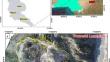
A massive landslide occurred in Domeshi area, District Muzaffarabad, Pakistan, in two distinct phases: an initial movement on August 1, followed by complete failure on August 4, 2023. The landslide movement persisted for 96 h, with a runout distance of 500 m. The event destroyed numerous residential structures, impacting multiple families, and causing extensive damage to cultivated land and road infrastructure. To comprehensively understand the failure mechanisms, a detailed study was undertaken, encompassing site investigations, unmanned aerial vehicle (UAV) photography, geotechnical and geophysical investigations, petrographic analysis, kinematics, and numerical simulations. The field evidence indicates that the active deformation along the Jhelum Fault (JF) within the landslide’s main body weakened the surrounding rock formations. Intense rainfall saturated pre-existing fractures, creating critical zones of weakness. Highly plastic clays along fault plane contributed significantly to volume changes, especially during and after rainfall events. Kinematic analysis identified bedding joints as prevalent failure planes for planar sliding. Geophysical survey revealed a layer of unconsolidated material extending 25–30 m below the landslide’s scarp, accompanied by various fractures, including a deep fracture (i.e., JF) up to 300 m depth. Petrographic investigations showed microfractures, micro faults, and intragranular mineral breakage, indicative of intense tectonic stresses. Slope stability analysis indicated factors of safety (FoS) and strength reduction factor (SRF) less than 1, suggesting the potential for further failure in the lower sections of the landslide. Multiple factors, including slope geometry, active tectonics, material composition, and anthropogenic factors (i.e., slope loading and cutting for road and building construction, improper drainage distribution), contributed to the landslide's occurrence, however, the rainfall emerged as the primary triggering event.
期刊介绍:
Landslides are gravitational mass movements of rock, debris or earth. They may occur in conjunction with other major natural disasters such as floods, earthquakes and volcanic eruptions. Expanding urbanization and changing land-use practices have increased the incidence of landslide disasters. Landslides as catastrophic events include human injury, loss of life and economic devastation and are studied as part of the fields of earth, water and engineering sciences. The aim of the journal Landslides is to be the common platform for the publication of integrated research on landslide processes, hazards, risk analysis, mitigation, and the protection of our cultural heritage and the environment. The journal publishes research papers, news of recent landslide events and information on the activities of the International Consortium on Landslides.
- Landslide dynamics, mechanisms and processes
- Landslide risk evaluation: hazard assessment, hazard mapping, and vulnerability assessment
- Geological, Geotechnical, Hydrological and Geophysical modeling
- Effects of meteorological, hydrological and global climatic change factors
- Monitoring including remote sensing and other non-invasive systems
- New technology, expert and intelligent systems
- Application of GIS techniques
- Rock slides, rock falls, debris flows, earth flows, and lateral spreads
- Large-scale landslides, lahars and pyroclastic flows in volcanic zones
- Marine and reservoir related landslides
- Landslide related tsunamis and seiches
- Landslide disasters in urban areas and along critical infrastructure
- Landslides and natural resources
- Land development and land-use practices
- Landslide remedial measures / prevention works
- Temporal and spatial prediction of landslides
- Early warning and evacuation
- Global landslide database

 求助内容:
求助内容: 应助结果提醒方式:


