{"title":"利用遥感和地理信息系统技术评估土地利用和土地覆被的变化:克什米尔山谷案例研究","authors":"Injila Hamid, Lateef Ahmad Dar, Bertug Akintug","doi":"10.1007/s12040-024-02369-1","DOIUrl":null,"url":null,"abstract":"<p>Land use land cover (LULC) changes hugely influence the ecological balance of an ecosystem, which adversely affects the inhabitants, making them more vulnerable to natural calamities. The LULC change studies are therefore carried out to analyze the impact of these changes on the overall ecology of an area and are very helpful in policy framing and proper management of the available natural resources. In this study, changes in the land use and land cover for a three-decade period spanning from 1992 to 2020 have been monitored in the valley of Kashmir using remotely sensed satellite data obtained from USGS/NASA’s Landsat repository. Considerable changes in the LULC patterns were observed with a significant reduction in the area covered by water (18.21%), forest (13.56%), snow/glacial cover (29.32%) and agriculture (22.37%) during the past three decades. Concurrently, expansion in the land covered by urban areas (22.33%), barren land (37.32%), plantation (14.53%) and marshes (13.21%) were noted. The calculated Normalized Difference Water Index (NDWI) confirmed an overall reduction of 51.1% in the water and glacial cover of the study area. Significant changes in the form of forest, water and glacial cover transforming into urban, marshy and barren areas can be largely accredited to increased human interference that may have serious repercussions on the environment.</p>","PeriodicalId":15609,"journal":{"name":"Journal of Earth System Science","volume":"9 1","pages":""},"PeriodicalIF":1.7000,"publicationDate":"2024-08-31","publicationTypes":"Journal Article","fieldsOfStudy":null,"isOpenAccess":false,"openAccessPdf":"","citationCount":"0","resultStr":"{\"title\":\"Assessing land use land cover change using remote sensing and GIS techniques: A case study of Kashmir Valley\",\"authors\":\"Injila Hamid, Lateef Ahmad Dar, Bertug Akintug\",\"doi\":\"10.1007/s12040-024-02369-1\",\"DOIUrl\":null,\"url\":null,\"abstract\":\"<p>Land use land cover (LULC) changes hugely influence the ecological balance of an ecosystem, which adversely affects the inhabitants, making them more vulnerable to natural calamities. The LULC change studies are therefore carried out to analyze the impact of these changes on the overall ecology of an area and are very helpful in policy framing and proper management of the available natural resources. In this study, changes in the land use and land cover for a three-decade period spanning from 1992 to 2020 have been monitored in the valley of Kashmir using remotely sensed satellite data obtained from USGS/NASA’s Landsat repository. Considerable changes in the LULC patterns were observed with a significant reduction in the area covered by water (18.21%), forest (13.56%), snow/glacial cover (29.32%) and agriculture (22.37%) during the past three decades. Concurrently, expansion in the land covered by urban areas (22.33%), barren land (37.32%), plantation (14.53%) and marshes (13.21%) were noted. The calculated Normalized Difference Water Index (NDWI) confirmed an overall reduction of 51.1% in the water and glacial cover of the study area. Significant changes in the form of forest, water and glacial cover transforming into urban, marshy and barren areas can be largely accredited to increased human interference that may have serious repercussions on the environment.</p>\",\"PeriodicalId\":15609,\"journal\":{\"name\":\"Journal of Earth System Science\",\"volume\":\"9 1\",\"pages\":\"\"},\"PeriodicalIF\":1.7000,\"publicationDate\":\"2024-08-31\",\"publicationTypes\":\"Journal Article\",\"fieldsOfStudy\":null,\"isOpenAccess\":false,\"openAccessPdf\":\"\",\"citationCount\":\"0\",\"resultStr\":null,\"platform\":\"Semanticscholar\",\"paperid\":null,\"PeriodicalName\":\"Journal of Earth System Science\",\"FirstCategoryId\":\"89\",\"ListUrlMain\":\"https://doi.org/10.1007/s12040-024-02369-1\",\"RegionNum\":4,\"RegionCategory\":\"地球科学\",\"ArticlePicture\":[],\"TitleCN\":null,\"AbstractTextCN\":null,\"PMCID\":null,\"EPubDate\":\"\",\"PubModel\":\"\",\"JCR\":\"Q3\",\"JCRName\":\"GEOSCIENCES, MULTIDISCIPLINARY\",\"Score\":null,\"Total\":0}","platform":"Semanticscholar","paperid":null,"PeriodicalName":"Journal of Earth System Science","FirstCategoryId":"89","ListUrlMain":"https://doi.org/10.1007/s12040-024-02369-1","RegionNum":4,"RegionCategory":"地球科学","ArticlePicture":[],"TitleCN":null,"AbstractTextCN":null,"PMCID":null,"EPubDate":"","PubModel":"","JCR":"Q3","JCRName":"GEOSCIENCES, MULTIDISCIPLINARY","Score":null,"Total":0}
Assessing land use land cover change using remote sensing and GIS techniques: A case study of Kashmir Valley
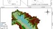
Land use land cover (LULC) changes hugely influence the ecological balance of an ecosystem, which adversely affects the inhabitants, making them more vulnerable to natural calamities. The LULC change studies are therefore carried out to analyze the impact of these changes on the overall ecology of an area and are very helpful in policy framing and proper management of the available natural resources. In this study, changes in the land use and land cover for a three-decade period spanning from 1992 to 2020 have been monitored in the valley of Kashmir using remotely sensed satellite data obtained from USGS/NASA’s Landsat repository. Considerable changes in the LULC patterns were observed with a significant reduction in the area covered by water (18.21%), forest (13.56%), snow/glacial cover (29.32%) and agriculture (22.37%) during the past three decades. Concurrently, expansion in the land covered by urban areas (22.33%), barren land (37.32%), plantation (14.53%) and marshes (13.21%) were noted. The calculated Normalized Difference Water Index (NDWI) confirmed an overall reduction of 51.1% in the water and glacial cover of the study area. Significant changes in the form of forest, water and glacial cover transforming into urban, marshy and barren areas can be largely accredited to increased human interference that may have serious repercussions on the environment.
期刊介绍:
The Journal of Earth System Science, an International Journal, was earlier a part of the Proceedings of the Indian Academy of Sciences – Section A begun in 1934, and later split in 1978 into theme journals. This journal was published as Proceedings – Earth and Planetary Sciences since 1978, and in 2005 was renamed ‘Journal of Earth System Science’.
The journal is highly inter-disciplinary and publishes scholarly research – new data, ideas, and conceptual advances – in Earth System Science. The focus is on the evolution of the Earth as a system: manuscripts describing changes of anthropogenic origin in a limited region are not considered unless they go beyond describing the changes to include an analysis of earth-system processes. The journal''s scope includes the solid earth (geosphere), the atmosphere, the hydrosphere (including cryosphere), and the biosphere; it also addresses related aspects of planetary and space sciences. Contributions pertaining to the Indian sub- continent and the surrounding Indian-Ocean region are particularly welcome. Given that a large number of manuscripts report either observations or model results for a limited domain, manuscripts intended for publication in JESS are expected to fulfill at least one of the following three criteria.
The data should be of relevance and should be of statistically significant size and from a region from where such data are sparse. If the data are from a well-sampled region, the data size should be considerable and advance our knowledge of the region.
A model study is carried out to explain observations reported either in the same manuscript or in the literature.
The analysis, whether of data or with models, is novel and the inferences advance the current knowledge.
 求助内容:
求助内容: 应助结果提醒方式:


