利用声纳系统探测海底气体排放区

IF 1.3 4区 地球科学 Q4 OCEANOGRAPHY
V. I. Kaevitser, V. M. Smirnov, I. V. Smolyaninov
{"title":"利用声纳系统探测海底气体排放区","authors":"V. I. Kaevitser, V. M. Smirnov, I. V. Smolyaninov","doi":"10.1134/s0001437024700280","DOIUrl":null,"url":null,"abstract":"<h3 data-test=\"abstract-sub-heading\">Abstract</h3><p>The study presents and analyzes the experimental results of geological and geomorphological observations in some marine areas with active gas emission from bottom sediments. The study was carried out using an instrumental complex of geophysical sonar equipment, which included a subbottom profiler and side scan bathymetric sonar that uses an interferometric method for measuring depths in the field of view. The results confirm the possibility of using the complex to classify the seabed morphology and control the processes of gas unloading. The use of sonar equipment for remote seabed mapping during satellite observations can be used to interpret the results of satellite remote sensing of the atmosphere.</p>","PeriodicalId":54692,"journal":{"name":"Oceanology","volume":null,"pages":null},"PeriodicalIF":1.3000,"publicationDate":"2024-08-26","publicationTypes":"Journal Article","fieldsOfStudy":null,"isOpenAccess":false,"openAccessPdf":"","citationCount":"0","resultStr":"{\"title\":\"Use of Sonar Systems to Detect Areas of Gas Discharge of the Seabed\",\"authors\":\"V. I. Kaevitser, V. M. Smirnov, I. V. Smolyaninov\",\"doi\":\"10.1134/s0001437024700280\",\"DOIUrl\":null,\"url\":null,\"abstract\":\"<h3 data-test=\\\"abstract-sub-heading\\\">Abstract</h3><p>The study presents and analyzes the experimental results of geological and geomorphological observations in some marine areas with active gas emission from bottom sediments. The study was carried out using an instrumental complex of geophysical sonar equipment, which included a subbottom profiler and side scan bathymetric sonar that uses an interferometric method for measuring depths in the field of view. The results confirm the possibility of using the complex to classify the seabed morphology and control the processes of gas unloading. The use of sonar equipment for remote seabed mapping during satellite observations can be used to interpret the results of satellite remote sensing of the atmosphere.</p>\",\"PeriodicalId\":54692,\"journal\":{\"name\":\"Oceanology\",\"volume\":null,\"pages\":null},\"PeriodicalIF\":1.3000,\"publicationDate\":\"2024-08-26\",\"publicationTypes\":\"Journal Article\",\"fieldsOfStudy\":null,\"isOpenAccess\":false,\"openAccessPdf\":\"\",\"citationCount\":\"0\",\"resultStr\":null,\"platform\":\"Semanticscholar\",\"paperid\":null,\"PeriodicalName\":\"Oceanology\",\"FirstCategoryId\":\"89\",\"ListUrlMain\":\"https://doi.org/10.1134/s0001437024700280\",\"RegionNum\":4,\"RegionCategory\":\"地球科学\",\"ArticlePicture\":[],\"TitleCN\":null,\"AbstractTextCN\":null,\"PMCID\":null,\"EPubDate\":\"\",\"PubModel\":\"\",\"JCR\":\"Q4\",\"JCRName\":\"OCEANOGRAPHY\",\"Score\":null,\"Total\":0}","platform":"Semanticscholar","paperid":null,"PeriodicalName":"Oceanology","FirstCategoryId":"89","ListUrlMain":"https://doi.org/10.1134/s0001437024700280","RegionNum":4,"RegionCategory":"地球科学","ArticlePicture":[],"TitleCN":null,"AbstractTextCN":null,"PMCID":null,"EPubDate":"","PubModel":"","JCR":"Q4","JCRName":"OCEANOGRAPHY","Score":null,"Total":0}
引用次数: 0

摘要

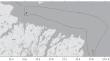
摘要 该研究介绍并分析了在一些海底沉积物气体排放活跃的海域进行地质和地貌观测的实验结果。这项研究是利用地球物理声纳设备仪器综合体进行的,其中包括一台海底剖面仪和侧扫测深声纳,后者采用干涉测量法测量视场深度。结果证实,可以利用该综合设备对海底形态进行分类,并控制天然气的卸载过程。在卫星观测期间使用声纳设备进行遥控海底测绘可用于解释大气层卫星遥感的结果。
本文章由计算机程序翻译,如有差异,请以英文原文为准。

Use of Sonar Systems to Detect Areas of Gas Discharge of the Seabed

Use of Sonar Systems to Detect Areas of Gas Discharge of the Seabed

Abstract

The study presents and analyzes the experimental results of geological and geomorphological observations in some marine areas with active gas emission from bottom sediments. The study was carried out using an instrumental complex of geophysical sonar equipment, which included a subbottom profiler and side scan bathymetric sonar that uses an interferometric method for measuring depths in the field of view. The results confirm the possibility of using the complex to classify the seabed morphology and control the processes of gas unloading. The use of sonar equipment for remote seabed mapping during satellite observations can be used to interpret the results of satellite remote sensing of the atmosphere.

求助全文
通过发布文献求助,成功后即可免费获取论文全文。 去求助
来源期刊
Oceanology
Oceanology 地学-海洋学
CiteScore
2.00
自引率
20.00%
发文量
83
审稿时长
6-12 weeks
期刊介绍: Oceanology, founded in 1961, is the leading journal in all areas of the marine sciences. It publishes original papers in all fields of theoretical and experimental research in physical, chemical, biological, geological, and technical oceanology. The journal also offers reviews and information about conferences, symposia, cruises, and other events of interest to the oceanographic community.
×
引用
GB/T 7714-2015
复制
MLA
复制
APA
复制
导出至
BibTeX EndNote RefMan NoteFirst NoteExpress
×
提示
您的信息不完整,为了账户安全,请先补充。
现在去补充
×
提示
您因"违规操作"
具体请查看互助需知
我知道了
×
提示
确定
请完成安全验证×
copy
已复制链接
快去分享给好友吧!
我知道了
右上角分享
点击右上角分享
0
联系我们:info@booksci.cn Book学术提供免费学术资源搜索服务,方便国内外学者检索中英文文献。致力于提供最便捷和优质的服务体验。 Copyright © 2023 布克学术 All rights reserved.
京ICP备2023020795号-1
ghs 京公网安备 11010802042870号
Book学术文献互助
Book学术文献互助群
群 号:481959085
Book学术官方微信