Michael Angelopoulos, Trond Ryberg, Christian Frigaard Rasmussen, Christian Haberland, Bennet Juhls, Scott Dallimore, Julia Boike, Pier Paul Overduin
{"title":"被动地震学:北极海底和水下永久冻土的轻量级快速探测","authors":"Michael Angelopoulos, Trond Ryberg, Christian Frigaard Rasmussen, Christian Haberland, Bennet Juhls, Scott Dallimore, Julia Boike, Pier Paul Overduin","doi":"10.1029/2023JF007290","DOIUrl":null,"url":null,"abstract":"<p>Low sea levels during the last Ice Age exposed millions of square kilometers of Arctic shelves which have been subsequently submerged, creating subsea permafrost. In onshore settings, permafrost can also exist beneath water bodies such as coastal lagoons, rivers, and thermokarst lakes. We explored passive seismology as a method for mapping unfrozen sediment thickness above subsea and sub-aquatic permafrost. We present passive seismic data collected with the Mobile Ocean Bottom Seismic Instrument (MOBSI) from the Beaufort Sea near Tuktoyaktuk in Canada, Ivashkina Lagoon on the Bykovsky Peninsula, as well as a lake and river in the Lena Delta, Siberia, Russia. We use borehole data and frost probe measurements to identify permafrost-related H/V measurement peaks and calibrate shear wave velocities for frequency-to-depth conversion. We employ the shortest path and maximum signal amplitude to connect peaks and generate geological profiles. The MOBSI detected the ice-bonded permafrost table beneath the Beaufort Sea, as well as beneath a Siberian lake and lagoon. At Tuktoyaktuk, an ocean bottom seismometer revealed a 5% scatter about the peak frequency for three-minute time windows and over 8 hr of recording time. With peak frequencies ranging from 4.9 ± 0.2 Hz to 27.6 ± 1.4 Hz, the depth to subsea permafrost ranged from 1.4 ± 0.1 m bsl at the shoreline to 14.0 ± 0.4 m bsl 240 m offshore. Given an accurate shear wave velocity, our findings highlight that MOBSI deployment times as short as 3 min are adequate for detecting Arctic subsea and sub-aquatic permafrost.</p>","PeriodicalId":15887,"journal":{"name":"Journal of Geophysical Research: Earth Surface","volume":"129 9","pages":""},"PeriodicalIF":3.5000,"publicationDate":"2024-09-07","publicationTypes":"Journal Article","fieldsOfStudy":null,"isOpenAccess":false,"openAccessPdf":"https://onlinelibrary.wiley.com/doi/epdf/10.1029/2023JF007290","citationCount":"0","resultStr":"{\"title\":\"Passive Seismology: Lightweight and Rapid Detection of Arctic Subsea and Sub-Aquatic Permafrost\",\"authors\":\"Michael Angelopoulos, Trond Ryberg, Christian Frigaard Rasmussen, Christian Haberland, Bennet Juhls, Scott Dallimore, Julia Boike, Pier Paul Overduin\",\"doi\":\"10.1029/2023JF007290\",\"DOIUrl\":null,\"url\":null,\"abstract\":\"<p>Low sea levels during the last Ice Age exposed millions of square kilometers of Arctic shelves which have been subsequently submerged, creating subsea permafrost. In onshore settings, permafrost can also exist beneath water bodies such as coastal lagoons, rivers, and thermokarst lakes. We explored passive seismology as a method for mapping unfrozen sediment thickness above subsea and sub-aquatic permafrost. We present passive seismic data collected with the Mobile Ocean Bottom Seismic Instrument (MOBSI) from the Beaufort Sea near Tuktoyaktuk in Canada, Ivashkina Lagoon on the Bykovsky Peninsula, as well as a lake and river in the Lena Delta, Siberia, Russia. We use borehole data and frost probe measurements to identify permafrost-related H/V measurement peaks and calibrate shear wave velocities for frequency-to-depth conversion. We employ the shortest path and maximum signal amplitude to connect peaks and generate geological profiles. The MOBSI detected the ice-bonded permafrost table beneath the Beaufort Sea, as well as beneath a Siberian lake and lagoon. At Tuktoyaktuk, an ocean bottom seismometer revealed a 5% scatter about the peak frequency for three-minute time windows and over 8 hr of recording time. With peak frequencies ranging from 4.9 ± 0.2 Hz to 27.6 ± 1.4 Hz, the depth to subsea permafrost ranged from 1.4 ± 0.1 m bsl at the shoreline to 14.0 ± 0.4 m bsl 240 m offshore. Given an accurate shear wave velocity, our findings highlight that MOBSI deployment times as short as 3 min are adequate for detecting Arctic subsea and sub-aquatic permafrost.</p>\",\"PeriodicalId\":15887,\"journal\":{\"name\":\"Journal of Geophysical Research: Earth Surface\",\"volume\":\"129 9\",\"pages\":\"\"},\"PeriodicalIF\":3.5000,\"publicationDate\":\"2024-09-07\",\"publicationTypes\":\"Journal Article\",\"fieldsOfStudy\":null,\"isOpenAccess\":false,\"openAccessPdf\":\"https://onlinelibrary.wiley.com/doi/epdf/10.1029/2023JF007290\",\"citationCount\":\"0\",\"resultStr\":null,\"platform\":\"Semanticscholar\",\"paperid\":null,\"PeriodicalName\":\"Journal of Geophysical Research: Earth Surface\",\"FirstCategoryId\":\"89\",\"ListUrlMain\":\"https://onlinelibrary.wiley.com/doi/10.1029/2023JF007290\",\"RegionNum\":2,\"RegionCategory\":\"地球科学\",\"ArticlePicture\":[],\"TitleCN\":null,\"AbstractTextCN\":null,\"PMCID\":null,\"EPubDate\":\"\",\"PubModel\":\"\",\"JCR\":\"Q1\",\"JCRName\":\"GEOSCIENCES, MULTIDISCIPLINARY\",\"Score\":null,\"Total\":0}","platform":"Semanticscholar","paperid":null,"PeriodicalName":"Journal of Geophysical Research: Earth Surface","FirstCategoryId":"89","ListUrlMain":"https://onlinelibrary.wiley.com/doi/10.1029/2023JF007290","RegionNum":2,"RegionCategory":"地球科学","ArticlePicture":[],"TitleCN":null,"AbstractTextCN":null,"PMCID":null,"EPubDate":"","PubModel":"","JCR":"Q1","JCRName":"GEOSCIENCES, MULTIDISCIPLINARY","Score":null,"Total":0}
Passive Seismology: Lightweight and Rapid Detection of Arctic Subsea and Sub-Aquatic Permafrost
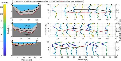
Low sea levels during the last Ice Age exposed millions of square kilometers of Arctic shelves which have been subsequently submerged, creating subsea permafrost. In onshore settings, permafrost can also exist beneath water bodies such as coastal lagoons, rivers, and thermokarst lakes. We explored passive seismology as a method for mapping unfrozen sediment thickness above subsea and sub-aquatic permafrost. We present passive seismic data collected with the Mobile Ocean Bottom Seismic Instrument (MOBSI) from the Beaufort Sea near Tuktoyaktuk in Canada, Ivashkina Lagoon on the Bykovsky Peninsula, as well as a lake and river in the Lena Delta, Siberia, Russia. We use borehole data and frost probe measurements to identify permafrost-related H/V measurement peaks and calibrate shear wave velocities for frequency-to-depth conversion. We employ the shortest path and maximum signal amplitude to connect peaks and generate geological profiles. The MOBSI detected the ice-bonded permafrost table beneath the Beaufort Sea, as well as beneath a Siberian lake and lagoon. At Tuktoyaktuk, an ocean bottom seismometer revealed a 5% scatter about the peak frequency for three-minute time windows and over 8 hr of recording time. With peak frequencies ranging from 4.9 ± 0.2 Hz to 27.6 ± 1.4 Hz, the depth to subsea permafrost ranged from 1.4 ± 0.1 m bsl at the shoreline to 14.0 ± 0.4 m bsl 240 m offshore. Given an accurate shear wave velocity, our findings highlight that MOBSI deployment times as short as 3 min are adequate for detecting Arctic subsea and sub-aquatic permafrost.

 求助内容:
求助内容: 应助结果提醒方式:


