Ke Wang, Jingyi Chen, Eirik Valseth, Gordon Wells, Srinivas Bettadpur, Cathleen E. Jones, Clint Dawson
{"title":"微妙的土地沉降加剧了美国墨西哥湾沿岸未来的风暴潮风险","authors":"Ke Wang, Jingyi Chen, Eirik Valseth, Gordon Wells, Srinivas Bettadpur, Cathleen E. Jones, Clint Dawson","doi":"10.1029/2024JF007858","DOIUrl":null,"url":null,"abstract":"<p>We developed a robust InSAR processing strategy that can effectively mitigate severe decorrelation noise in a large volume of InSAR data. We mapped the average land subsidence rate (2017–2020) over the 131,572 km<sup>2</sup> Upper Texas and Louisiana coasts from Sentinel-1 data, with ∼2 mm/yr accuracy based on independent GPS and tide gauge validation at 189 locations. The improved InSAR observations reveal widespread subsidence that was previously undetected in coastal wetlands and rural areas with small communities. Our InSAR surface deformation map is at the spatial scale that overlaps with the scale of hydrodynamic model grids. This allows us to integrate InSAR observations into operational storm surge models to analyze future flooding risks due to relative sea level change. We found that these subtle millimeter-to-centimeter subsidence features can substantially increase hurricane-induced inundation, and passive flood mapping (known as the “bathtub” approach) can lead to inaccurate flood risk predictions.</p>","PeriodicalId":15887,"journal":{"name":"Journal of Geophysical Research: Earth Surface","volume":"129 9","pages":""},"PeriodicalIF":3.8000,"publicationDate":"2024-09-03","publicationTypes":"Journal Article","fieldsOfStudy":null,"isOpenAccess":false,"openAccessPdf":"https://onlinelibrary.wiley.com/doi/epdf/10.1029/2024JF007858","citationCount":"0","resultStr":"{\"title\":\"Subtle Land Subsidence Elevates Future Storm Surge Risks Along the Gulf Coast of the United States\",\"authors\":\"Ke Wang, Jingyi Chen, Eirik Valseth, Gordon Wells, Srinivas Bettadpur, Cathleen E. Jones, Clint Dawson\",\"doi\":\"10.1029/2024JF007858\",\"DOIUrl\":null,\"url\":null,\"abstract\":\"<p>We developed a robust InSAR processing strategy that can effectively mitigate severe decorrelation noise in a large volume of InSAR data. We mapped the average land subsidence rate (2017–2020) over the 131,572 km<sup>2</sup> Upper Texas and Louisiana coasts from Sentinel-1 data, with ∼2 mm/yr accuracy based on independent GPS and tide gauge validation at 189 locations. The improved InSAR observations reveal widespread subsidence that was previously undetected in coastal wetlands and rural areas with small communities. Our InSAR surface deformation map is at the spatial scale that overlaps with the scale of hydrodynamic model grids. This allows us to integrate InSAR observations into operational storm surge models to analyze future flooding risks due to relative sea level change. We found that these subtle millimeter-to-centimeter subsidence features can substantially increase hurricane-induced inundation, and passive flood mapping (known as the “bathtub” approach) can lead to inaccurate flood risk predictions.</p>\",\"PeriodicalId\":15887,\"journal\":{\"name\":\"Journal of Geophysical Research: Earth Surface\",\"volume\":\"129 9\",\"pages\":\"\"},\"PeriodicalIF\":3.8000,\"publicationDate\":\"2024-09-03\",\"publicationTypes\":\"Journal Article\",\"fieldsOfStudy\":null,\"isOpenAccess\":false,\"openAccessPdf\":\"https://onlinelibrary.wiley.com/doi/epdf/10.1029/2024JF007858\",\"citationCount\":\"0\",\"resultStr\":null,\"platform\":\"Semanticscholar\",\"paperid\":null,\"PeriodicalName\":\"Journal of Geophysical Research: Earth Surface\",\"FirstCategoryId\":\"89\",\"ListUrlMain\":\"https://onlinelibrary.wiley.com/doi/10.1029/2024JF007858\",\"RegionNum\":2,\"RegionCategory\":\"地球科学\",\"ArticlePicture\":[],\"TitleCN\":null,\"AbstractTextCN\":null,\"PMCID\":null,\"EPubDate\":\"\",\"PubModel\":\"\",\"JCR\":\"Q1\",\"JCRName\":\"GEOSCIENCES, MULTIDISCIPLINARY\",\"Score\":null,\"Total\":0}","platform":"Semanticscholar","paperid":null,"PeriodicalName":"Journal of Geophysical Research: Earth Surface","FirstCategoryId":"89","ListUrlMain":"https://onlinelibrary.wiley.com/doi/10.1029/2024JF007858","RegionNum":2,"RegionCategory":"地球科学","ArticlePicture":[],"TitleCN":null,"AbstractTextCN":null,"PMCID":null,"EPubDate":"","PubModel":"","JCR":"Q1","JCRName":"GEOSCIENCES, MULTIDISCIPLINARY","Score":null,"Total":0}
Subtle Land Subsidence Elevates Future Storm Surge Risks Along the Gulf Coast of the United States
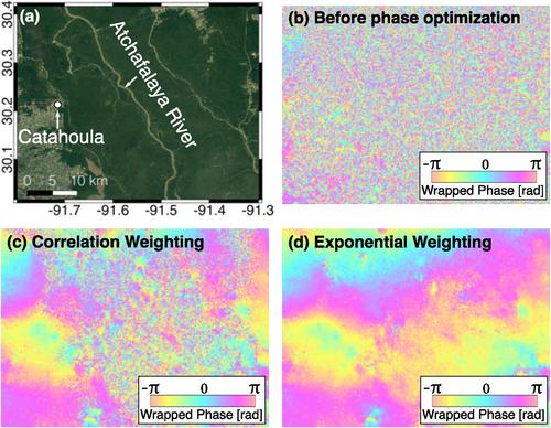
We developed a robust InSAR processing strategy that can effectively mitigate severe decorrelation noise in a large volume of InSAR data. We mapped the average land subsidence rate (2017–2020) over the 131,572 km2 Upper Texas and Louisiana coasts from Sentinel-1 data, with ∼2 mm/yr accuracy based on independent GPS and tide gauge validation at 189 locations. The improved InSAR observations reveal widespread subsidence that was previously undetected in coastal wetlands and rural areas with small communities. Our InSAR surface deformation map is at the spatial scale that overlaps with the scale of hydrodynamic model grids. This allows us to integrate InSAR observations into operational storm surge models to analyze future flooding risks due to relative sea level change. We found that these subtle millimeter-to-centimeter subsidence features can substantially increase hurricane-induced inundation, and passive flood mapping (known as the “bathtub” approach) can lead to inaccurate flood risk predictions.

 求助内容:
求助内容: 应助结果提醒方式:


