Victor Hugo Sarrazin Lima , Fernando António Leal Pacheco , João Paulo Moura , Teresa Cristina Tarlé Pissarra , Renato Farias do Valle Junior , Maytê Maria Abreu Pires de Melo Silva , Adriana Monteiro da Costa , Carlos Alberto Valera , Marília Carvalho de Melo , Luís Filipe Sanches Fernandes
{"title":"保护地下水资源免受多重危害:风险评估与流域管理相结合","authors":"Victor Hugo Sarrazin Lima , Fernando António Leal Pacheco , João Paulo Moura , Teresa Cristina Tarlé Pissarra , Renato Farias do Valle Junior , Maytê Maria Abreu Pires de Melo Silva , Adriana Monteiro da Costa , Carlos Alberto Valera , Marília Carvalho de Melo , Luís Filipe Sanches Fernandes","doi":"10.1016/j.gsd.2024.101326","DOIUrl":null,"url":null,"abstract":"<div><p>Mining areas are abundant in this basin and were allocated high values of <em>H</em> and low to high values of <em>V</em>, requesting implementation of groundwater monitoring and periodic inspection of mining sites, even more because groundwater contamination with iron could be clearly associated with the presence of mine-tailings. The improving groundwater resource protection depends on aligning contamination risk mapping with aquifer protection measures. However, existing methods often fail to align with aquifer protection goals, hindering practical implementation. The study demonstrated integrating vulnerability assessment, hazard evaluation, and groundwater protection initiatives using an L-Matrix approach. Testing this model in a well-documented watershed with multiple hazards to illustrates its applicability, providing a reference for similar scenarios. The risk was assessed through evaluation of aquifer vulnerability, using the DRASTIC method, coupled with the evaluation of a hazard potential considering industrial, livestock/agriculture and urban infrastructure sources in separate. The L-Matrix diagrams consisted of cartesian representations of V versus H, ranging from 0 to 1, segmented into four quadrants bounded by the cut-off lines V = 0.5 and H = 0.5. The quadrants were then linked to aquifer protection measures, with site inspection (high V and H), groundwater monitoring (low V and high H), land use planning (high V and low H), and tolerable expansion of hazardous activities (low V and H). The Paraopeba River basin was used as test site. Mining areas are abundant in this basin and were allocated high values of <em>H</em> and low to high values of <em>V</em>, requesting implementation of groundwater monitoring and periodic inspection of mining sites, even more because groundwater contamination with iron could be clearly associated with the presence of mine-tailings. In the results, it was observed that the DRASTIC vulnerability map of the aquifers has a mean vulnerability around the central value (V = 0.48 ± 0.08). Regarding the distribution of hazards, the average rounds to the value for to (H<sub>industry</sub> = 0.41 ± 0.37, H<sub>agriculture</sub> = 0.33 ± 0.09 and H<sub>infrastructure</sub> = 0.27 ± 0.14). Thus, it is noted that for industrial activities, the risk of contamination could be moderate to high, while for agricultural and livestock activities, the risk lies between low and moderate contamination impact.</p></div>","PeriodicalId":37879,"journal":{"name":"Groundwater for Sustainable Development","volume":"27 ","pages":"Article 101326"},"PeriodicalIF":4.9000,"publicationDate":"2024-08-30","publicationTypes":"Journal Article","fieldsOfStudy":null,"isOpenAccess":false,"openAccessPdf":"https://www.sciencedirect.com/science/article/pii/S2352801X24002492/pdfft?md5=71d259e68c918eefb47589891de5cd3b&pid=1-s2.0-S2352801X24002492-main.pdf","citationCount":"0","resultStr":"{\"title\":\"Protection of groundwater resources from multi-hazards: An integration of risk assessment and watershed management\",\"authors\":\"Victor Hugo Sarrazin Lima , Fernando António Leal Pacheco , João Paulo Moura , Teresa Cristina Tarlé Pissarra , Renato Farias do Valle Junior , Maytê Maria Abreu Pires de Melo Silva , Adriana Monteiro da Costa , Carlos Alberto Valera , Marília Carvalho de Melo , Luís Filipe Sanches Fernandes\",\"doi\":\"10.1016/j.gsd.2024.101326\",\"DOIUrl\":null,\"url\":null,\"abstract\":\"<div><p>Mining areas are abundant in this basin and were allocated high values of <em>H</em> and low to high values of <em>V</em>, requesting implementation of groundwater monitoring and periodic inspection of mining sites, even more because groundwater contamination with iron could be clearly associated with the presence of mine-tailings. The improving groundwater resource protection depends on aligning contamination risk mapping with aquifer protection measures. However, existing methods often fail to align with aquifer protection goals, hindering practical implementation. The study demonstrated integrating vulnerability assessment, hazard evaluation, and groundwater protection initiatives using an L-Matrix approach. Testing this model in a well-documented watershed with multiple hazards to illustrates its applicability, providing a reference for similar scenarios. The risk was assessed through evaluation of aquifer vulnerability, using the DRASTIC method, coupled with the evaluation of a hazard potential considering industrial, livestock/agriculture and urban infrastructure sources in separate. The L-Matrix diagrams consisted of cartesian representations of V versus H, ranging from 0 to 1, segmented into four quadrants bounded by the cut-off lines V = 0.5 and H = 0.5. The quadrants were then linked to aquifer protection measures, with site inspection (high V and H), groundwater monitoring (low V and high H), land use planning (high V and low H), and tolerable expansion of hazardous activities (low V and H). The Paraopeba River basin was used as test site. Mining areas are abundant in this basin and were allocated high values of <em>H</em> and low to high values of <em>V</em>, requesting implementation of groundwater monitoring and periodic inspection of mining sites, even more because groundwater contamination with iron could be clearly associated with the presence of mine-tailings. In the results, it was observed that the DRASTIC vulnerability map of the aquifers has a mean vulnerability around the central value (V = 0.48 ± 0.08). Regarding the distribution of hazards, the average rounds to the value for to (H<sub>industry</sub> = 0.41 ± 0.37, H<sub>agriculture</sub> = 0.33 ± 0.09 and H<sub>infrastructure</sub> = 0.27 ± 0.14). Thus, it is noted that for industrial activities, the risk of contamination could be moderate to high, while for agricultural and livestock activities, the risk lies between low and moderate contamination impact.</p></div>\",\"PeriodicalId\":37879,\"journal\":{\"name\":\"Groundwater for Sustainable Development\",\"volume\":\"27 \",\"pages\":\"Article 101326\"},\"PeriodicalIF\":4.9000,\"publicationDate\":\"2024-08-30\",\"publicationTypes\":\"Journal Article\",\"fieldsOfStudy\":null,\"isOpenAccess\":false,\"openAccessPdf\":\"https://www.sciencedirect.com/science/article/pii/S2352801X24002492/pdfft?md5=71d259e68c918eefb47589891de5cd3b&pid=1-s2.0-S2352801X24002492-main.pdf\",\"citationCount\":\"0\",\"resultStr\":null,\"platform\":\"Semanticscholar\",\"paperid\":null,\"PeriodicalName\":\"Groundwater for Sustainable Development\",\"FirstCategoryId\":\"1085\",\"ListUrlMain\":\"https://www.sciencedirect.com/science/article/pii/S2352801X24002492\",\"RegionNum\":0,\"RegionCategory\":null,\"ArticlePicture\":[],\"TitleCN\":null,\"AbstractTextCN\":null,\"PMCID\":null,\"EPubDate\":\"\",\"PubModel\":\"\",\"JCR\":\"Q2\",\"JCRName\":\"ENGINEERING, ENVIRONMENTAL\",\"Score\":null,\"Total\":0}","platform":"Semanticscholar","paperid":null,"PeriodicalName":"Groundwater for Sustainable Development","FirstCategoryId":"1085","ListUrlMain":"https://www.sciencedirect.com/science/article/pii/S2352801X24002492","RegionNum":0,"RegionCategory":null,"ArticlePicture":[],"TitleCN":null,"AbstractTextCN":null,"PMCID":null,"EPubDate":"","PubModel":"","JCR":"Q2","JCRName":"ENGINEERING, ENVIRONMENTAL","Score":null,"Total":0}
引用次数: 0
摘要
该流域矿区众多,H 值较高,V 值从低到高,因此需要对矿区进行地下水监测和定期检查,更重要的是,地下水的铁污染可能与矿尾的存在明显相关。改善地下水资源保护取决于将污染风险绘图与含水层保护措施相结合。然而,现有方法往往无法与含水层保护目标保持一致,阻碍了实际实施。该研究展示了利用 L 矩阵方法整合脆弱性评估、危害评估和地下水保护措施。在一个具有多种危害的有据可查的流域中测试该模型,以说明其适用性,为类似情况提供参考。采用 DRASTIC 方法对含水层的脆弱性进行评估,同时考虑到工业、畜牧业/农业和城市基础设施的潜在危害,分别对风险进行评估。L 矩阵图包括 V 与 H 的直角坐标图,范围从 0 到 1,分为四个象限,以 V = 0.5 和 H = 0.5 为分界线。然后将这些象限与含水层保护措施联系起来,包括现场检查(高 V 值和 H 值)、地下水监测(低 V 值和高 H 值)、土地利用规划(高 V 值和低 H 值)以及危险活动的可容忍扩展(低 V 值和 H 值)。Paraopeba 河流域被用作测试地点。该流域矿区众多,H 值较高,V 值从低到高,因此需要对矿区进行地下水监测和定期检查,更因为地下水的铁污染明显与矿尾的存在有关。结果表明,含水层 DRASTIC 脆弱性图的平均脆弱程度在中心值附近(V = 0.48 ± 0.08)。在危害分布方面,平均值为(Hindustry = 0.41 ± 0.37,Hagriculture = 0.33 ± 0.09,Hinfrastructure = 0.27 ± 0.14)。由此可见,工业活动的污染风险为中度到高度,而农业和畜牧业活动的污染风险则介于低度和中度之间。
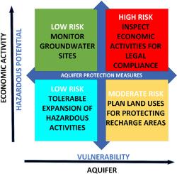
Protection of groundwater resources from multi-hazards: An integration of risk assessment and watershed management
Mining areas are abundant in this basin and were allocated high values of H and low to high values of V, requesting implementation of groundwater monitoring and periodic inspection of mining sites, even more because groundwater contamination with iron could be clearly associated with the presence of mine-tailings. The improving groundwater resource protection depends on aligning contamination risk mapping with aquifer protection measures. However, existing methods often fail to align with aquifer protection goals, hindering practical implementation. The study demonstrated integrating vulnerability assessment, hazard evaluation, and groundwater protection initiatives using an L-Matrix approach. Testing this model in a well-documented watershed with multiple hazards to illustrates its applicability, providing a reference for similar scenarios. The risk was assessed through evaluation of aquifer vulnerability, using the DRASTIC method, coupled with the evaluation of a hazard potential considering industrial, livestock/agriculture and urban infrastructure sources in separate. The L-Matrix diagrams consisted of cartesian representations of V versus H, ranging from 0 to 1, segmented into four quadrants bounded by the cut-off lines V = 0.5 and H = 0.5. The quadrants were then linked to aquifer protection measures, with site inspection (high V and H), groundwater monitoring (low V and high H), land use planning (high V and low H), and tolerable expansion of hazardous activities (low V and H). The Paraopeba River basin was used as test site. Mining areas are abundant in this basin and were allocated high values of H and low to high values of V, requesting implementation of groundwater monitoring and periodic inspection of mining sites, even more because groundwater contamination with iron could be clearly associated with the presence of mine-tailings. In the results, it was observed that the DRASTIC vulnerability map of the aquifers has a mean vulnerability around the central value (V = 0.48 ± 0.08). Regarding the distribution of hazards, the average rounds to the value for to (Hindustry = 0.41 ± 0.37, Hagriculture = 0.33 ± 0.09 and Hinfrastructure = 0.27 ± 0.14). Thus, it is noted that for industrial activities, the risk of contamination could be moderate to high, while for agricultural and livestock activities, the risk lies between low and moderate contamination impact.
期刊介绍:
Groundwater for Sustainable Development is directed to different stakeholders and professionals, including government and non-governmental organizations, international funding agencies, universities, public water institutions, public health and other public/private sector professionals, and other relevant institutions. It is aimed at professionals, academics and students in the fields of disciplines such as: groundwater and its connection to surface hydrology and environment, soil sciences, engineering, ecology, microbiology, atmospheric sciences, analytical chemistry, hydro-engineering, water technology, environmental ethics, economics, public health, policy, as well as social sciences, legal disciplines, or any other area connected with water issues. The objectives of this journal are to facilitate: • The improvement of effective and sustainable management of water resources across the globe. • The improvement of human access to groundwater resources in adequate quantity and good quality. • The meeting of the increasing demand for drinking and irrigation water needed for food security to contribute to a social and economically sound human development. • The creation of a global inter- and multidisciplinary platform and forum to improve our understanding of groundwater resources and to advocate their effective and sustainable management and protection against contamination. • Interdisciplinary information exchange and to stimulate scientific research in the fields of groundwater related sciences and social and health sciences required to achieve the United Nations Millennium Development Goals for sustainable development.

 求助内容:
求助内容: 应助结果提醒方式:


