{"title":"量化降水、地形和人类活动及其耦合对永久性沟谷形成的影响","authors":"","doi":"10.1016/j.geoderma.2024.117015","DOIUrl":null,"url":null,"abstract":"<div><p>Gully erosion poses greater threat to ecological and food security globally. The gully development rate and the contributions of primary influencing factors have not been thoroughly understood, primarily due to the complicated environmental conditions characterized by climate, soil, topography, and human activities. Therefore, this study was conducted to explore the gully development and contributions of its driving factors from 2013 to 2021 based on historical Google Earth images and field investigation in a typical rolling hilly watershed of northeast China. The climatic factors reflected by precipitation, topographical factors related to gully, and anthropological factors reflected by tillage ridge orientation and linear anthropological factors (LAF) including roads and shelterbelts were obtained. The tillage effect index (TEI), LAF effect index (LEI) and the distance from gully to LAF (D<sub>L</sub>) were calculated to analyze the influence of anthropological factors on gully development. The results showed that the linear, areal and volumetric gully development rates (R<sub>L</sub>, R<sub>A</sub> and R<sub>V</sub>) showed great variabilities in different periods with the average of 5.69 m year<sup>−1</sup>, 137.37 m<sup>2</sup> year<sup>−1</sup> and 428.54 m<sup>3</sup> year<sup>−1</sup>, respectively. The accumulated R<sub>L</sub>, R<sub>A</sub> and R<sub>V</sub> increased exponentially or linearly with accumulated precipitation amount (P), erosive rainfall duration (RD), erosive rainfall (ER), maximum 30-min rainfall intensity (I30) and rainfall erosivity (RE) increased (P < 0.001). The slope of the gully head (HS) was identified as the primary topographic factor influencing R<sub>L</sub>. Both R<sub>A</sub> and R<sub>V</sub> showed positive power relationships with the drainage area of the gully (CA) and the upstream gully head (HA). The human activity reflected by tillage ridge orientation, unpaved road and shelterbelts had different effects on R<sub>L</sub> and R<sub>A</sub>. The increased orientation angle between gully and tillage ridge (ROA) mitigated headcut retreat for normal precipitation year but it would aggravate headcut retreat in the periods of continuous heavy rainfall. Gully bank with the ROA of 30−90° was more prone to areal development. The TEI, LEI and D<sub>L</sub> had significantly positive linear, power or exponential relations with gully development rates. The PLSR and VPA analysis indicated that topography, the interaction between topography and human activity, and the coupled effects of precipitation, topography and human activity were the main contributor of R<sub>L</sub>, R<sub>A</sub> and R<sub>V</sub>, respectively, and accounted for 34 %, 50 %, and 40 % of total variability of R<sub>L</sub>, R<sub>A</sub> and R<sub>A</sub>, respectively. This study can provide guidance for the control of gully erosion and the optimization of land use structure in the gully catchment.</p></div>","PeriodicalId":12511,"journal":{"name":"Geoderma","volume":null,"pages":null},"PeriodicalIF":5.6000,"publicationDate":"2024-09-01","publicationTypes":"Journal Article","fieldsOfStudy":null,"isOpenAccess":false,"openAccessPdf":"https://www.sciencedirect.com/science/article/pii/S0016706124002441/pdfft?md5=50b31b88815f70f0a6fa8264994552ac&pid=1-s2.0-S0016706124002441-main.pdf","citationCount":"0","resultStr":"{\"title\":\"Quantifying the contributions of precipitation, topography and human activity and their coupling to the development of permanent gully\",\"authors\":\"\",\"doi\":\"10.1016/j.geoderma.2024.117015\",\"DOIUrl\":null,\"url\":null,\"abstract\":\"<div><p>Gully erosion poses greater threat to ecological and food security globally. The gully development rate and the contributions of primary influencing factors have not been thoroughly understood, primarily due to the complicated environmental conditions characterized by climate, soil, topography, and human activities. Therefore, this study was conducted to explore the gully development and contributions of its driving factors from 2013 to 2021 based on historical Google Earth images and field investigation in a typical rolling hilly watershed of northeast China. The climatic factors reflected by precipitation, topographical factors related to gully, and anthropological factors reflected by tillage ridge orientation and linear anthropological factors (LAF) including roads and shelterbelts were obtained. The tillage effect index (TEI), LAF effect index (LEI) and the distance from gully to LAF (D<sub>L</sub>) were calculated to analyze the influence of anthropological factors on gully development. The results showed that the linear, areal and volumetric gully development rates (R<sub>L</sub>, R<sub>A</sub> and R<sub>V</sub>) showed great variabilities in different periods with the average of 5.69 m year<sup>−1</sup>, 137.37 m<sup>2</sup> year<sup>−1</sup> and 428.54 m<sup>3</sup> year<sup>−1</sup>, respectively. The accumulated R<sub>L</sub>, R<sub>A</sub> and R<sub>V</sub> increased exponentially or linearly with accumulated precipitation amount (P), erosive rainfall duration (RD), erosive rainfall (ER), maximum 30-min rainfall intensity (I30) and rainfall erosivity (RE) increased (P < 0.001). The slope of the gully head (HS) was identified as the primary topographic factor influencing R<sub>L</sub>. Both R<sub>A</sub> and R<sub>V</sub> showed positive power relationships with the drainage area of the gully (CA) and the upstream gully head (HA). The human activity reflected by tillage ridge orientation, unpaved road and shelterbelts had different effects on R<sub>L</sub> and R<sub>A</sub>. The increased orientation angle between gully and tillage ridge (ROA) mitigated headcut retreat for normal precipitation year but it would aggravate headcut retreat in the periods of continuous heavy rainfall. Gully bank with the ROA of 30−90° was more prone to areal development. The TEI, LEI and D<sub>L</sub> had significantly positive linear, power or exponential relations with gully development rates. The PLSR and VPA analysis indicated that topography, the interaction between topography and human activity, and the coupled effects of precipitation, topography and human activity were the main contributor of R<sub>L</sub>, R<sub>A</sub> and R<sub>V</sub>, respectively, and accounted for 34 %, 50 %, and 40 % of total variability of R<sub>L</sub>, R<sub>A</sub> and R<sub>A</sub>, respectively. This study can provide guidance for the control of gully erosion and the optimization of land use structure in the gully catchment.</p></div>\",\"PeriodicalId\":12511,\"journal\":{\"name\":\"Geoderma\",\"volume\":null,\"pages\":null},\"PeriodicalIF\":5.6000,\"publicationDate\":\"2024-09-01\",\"publicationTypes\":\"Journal Article\",\"fieldsOfStudy\":null,\"isOpenAccess\":false,\"openAccessPdf\":\"https://www.sciencedirect.com/science/article/pii/S0016706124002441/pdfft?md5=50b31b88815f70f0a6fa8264994552ac&pid=1-s2.0-S0016706124002441-main.pdf\",\"citationCount\":\"0\",\"resultStr\":null,\"platform\":\"Semanticscholar\",\"paperid\":null,\"PeriodicalName\":\"Geoderma\",\"FirstCategoryId\":\"97\",\"ListUrlMain\":\"https://www.sciencedirect.com/science/article/pii/S0016706124002441\",\"RegionNum\":1,\"RegionCategory\":\"农林科学\",\"ArticlePicture\":[],\"TitleCN\":null,\"AbstractTextCN\":null,\"PMCID\":null,\"EPubDate\":\"\",\"PubModel\":\"\",\"JCR\":\"Q1\",\"JCRName\":\"SOIL SCIENCE\",\"Score\":null,\"Total\":0}","platform":"Semanticscholar","paperid":null,"PeriodicalName":"Geoderma","FirstCategoryId":"97","ListUrlMain":"https://www.sciencedirect.com/science/article/pii/S0016706124002441","RegionNum":1,"RegionCategory":"农林科学","ArticlePicture":[],"TitleCN":null,"AbstractTextCN":null,"PMCID":null,"EPubDate":"","PubModel":"","JCR":"Q1","JCRName":"SOIL SCIENCE","Score":null,"Total":0}
Quantifying the contributions of precipitation, topography and human activity and their coupling to the development of permanent gully
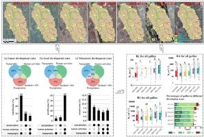
Gully erosion poses greater threat to ecological and food security globally. The gully development rate and the contributions of primary influencing factors have not been thoroughly understood, primarily due to the complicated environmental conditions characterized by climate, soil, topography, and human activities. Therefore, this study was conducted to explore the gully development and contributions of its driving factors from 2013 to 2021 based on historical Google Earth images and field investigation in a typical rolling hilly watershed of northeast China. The climatic factors reflected by precipitation, topographical factors related to gully, and anthropological factors reflected by tillage ridge orientation and linear anthropological factors (LAF) including roads and shelterbelts were obtained. The tillage effect index (TEI), LAF effect index (LEI) and the distance from gully to LAF (DL) were calculated to analyze the influence of anthropological factors on gully development. The results showed that the linear, areal and volumetric gully development rates (RL, RA and RV) showed great variabilities in different periods with the average of 5.69 m year−1, 137.37 m2 year−1 and 428.54 m3 year−1, respectively. The accumulated RL, RA and RV increased exponentially or linearly with accumulated precipitation amount (P), erosive rainfall duration (RD), erosive rainfall (ER), maximum 30-min rainfall intensity (I30) and rainfall erosivity (RE) increased (P < 0.001). The slope of the gully head (HS) was identified as the primary topographic factor influencing RL. Both RA and RV showed positive power relationships with the drainage area of the gully (CA) and the upstream gully head (HA). The human activity reflected by tillage ridge orientation, unpaved road and shelterbelts had different effects on RL and RA. The increased orientation angle between gully and tillage ridge (ROA) mitigated headcut retreat for normal precipitation year but it would aggravate headcut retreat in the periods of continuous heavy rainfall. Gully bank with the ROA of 30−90° was more prone to areal development. The TEI, LEI and DL had significantly positive linear, power or exponential relations with gully development rates. The PLSR and VPA analysis indicated that topography, the interaction between topography and human activity, and the coupled effects of precipitation, topography and human activity were the main contributor of RL, RA and RV, respectively, and accounted for 34 %, 50 %, and 40 % of total variability of RL, RA and RA, respectively. This study can provide guidance for the control of gully erosion and the optimization of land use structure in the gully catchment.
期刊介绍:
Geoderma - the global journal of soil science - welcomes authors, readers and soil research from all parts of the world, encourages worldwide soil studies, and embraces all aspects of soil science and its associated pedagogy. The journal particularly welcomes interdisciplinary work focusing on dynamic soil processes and functions across space and time.

 求助内容:
求助内容: 应助结果提醒方式:


