Rubson P. Maia, Augusto S. Auler, Francisco H. R. Bezerra, Sérgio V. F. Borges, Vincenzo La Bruna, Diego Pujoni, Eliana E. dos Santos, Alexandre C. Vidal
{"title":"根据巴西伊雷塞盆地碳酸盐岩中的崩塌白云岩推断出的沿断裂走廊流体流动区","authors":"Rubson P. Maia, Augusto S. Auler, Francisco H. R. Bezerra, Sérgio V. F. Borges, Vincenzo La Bruna, Diego Pujoni, Eliana E. dos Santos, Alexandre C. Vidal","doi":"10.1002/esp.5951","DOIUrl":null,"url":null,"abstract":"<p>Dolines are a widespread karst landform, and understanding their genesis can provide critical information about the evolution of subsurface karstification and groundwater flow zones. Swarms of collapse dolines characterise the karst in the southern portion of the Irecê Basin, northeastern Brazil. The basin comprises Neoproterozoic carbonate rocks approximately 100 m thick, bounded by less soluble older quartzites. The distribution of dolines is not uniform, as they cluster along NW-SE axes and are aligned with cave systems and permeability (fracture) corridors mostly associated with the Almas and Água de Rega ephemeral rivers. Detailed analysis of sectors with a higher density of dolines was performed using LiDAR and unmanned aerial vehicle (UAV) imagery at two different scales to obtain morphometric and orientation patterns. As expected, scale dependency is observed, with an increase in density and circularity index at a higher resolution scale, but a decrease in mean area and perimeter. However, Voronoi polygon indices are similar at both scales (6.86 ± 1); the departure from the more stable number of six due to the clustering of dolines associated with NW-SE oriented structural trends. Doline density trends closely follow the orientation of caves, but they are not always spatially connected, since doline evolution may either occlude the caves or be related to a non-identified void. The Irecê Basin karst system displays a continuum of landforms evolving initially from high-density fracture zones (fracture corridors), which work as favourable dissolution zones, grading into more integrated flow routes, cave systems and eventually clusters of collapse dolines. Collapse dolines are widespread karst landforms worldwide, and their genesis requires the presence of dissolution voids at depth, which may pass undetected from the surface. In some sectors of Irecê Basin, the existence of doline alignments but the absence of known caves indicates the potential of collapse dolines to be used as proxies for subsurface karstification. Such an approach may allow the prediction of the location and orientation of subsurface zones of enhanced dissolution that can potentially represent productive aquifers or favourable zones for geofluids.</p>","PeriodicalId":11408,"journal":{"name":"Earth Surface Processes and Landforms","volume":"49 13","pages":"4506-4522"},"PeriodicalIF":2.8000,"publicationDate":"2024-08-05","publicationTypes":"Journal Article","fieldsOfStudy":null,"isOpenAccess":false,"openAccessPdf":"","citationCount":"0","resultStr":"{\"title\":\"Fluid flow zones along fracture corridors inferred from collapse dolines in carbonates of the Irecê Basin, Brazil\",\"authors\":\"Rubson P. Maia, Augusto S. Auler, Francisco H. R. Bezerra, Sérgio V. F. Borges, Vincenzo La Bruna, Diego Pujoni, Eliana E. dos Santos, Alexandre C. Vidal\",\"doi\":\"10.1002/esp.5951\",\"DOIUrl\":null,\"url\":null,\"abstract\":\"<p>Dolines are a widespread karst landform, and understanding their genesis can provide critical information about the evolution of subsurface karstification and groundwater flow zones. Swarms of collapse dolines characterise the karst in the southern portion of the Irecê Basin, northeastern Brazil. The basin comprises Neoproterozoic carbonate rocks approximately 100 m thick, bounded by less soluble older quartzites. The distribution of dolines is not uniform, as they cluster along NW-SE axes and are aligned with cave systems and permeability (fracture) corridors mostly associated with the Almas and Água de Rega ephemeral rivers. Detailed analysis of sectors with a higher density of dolines was performed using LiDAR and unmanned aerial vehicle (UAV) imagery at two different scales to obtain morphometric and orientation patterns. As expected, scale dependency is observed, with an increase in density and circularity index at a higher resolution scale, but a decrease in mean area and perimeter. However, Voronoi polygon indices are similar at both scales (6.86 ± 1); the departure from the more stable number of six due to the clustering of dolines associated with NW-SE oriented structural trends. Doline density trends closely follow the orientation of caves, but they are not always spatially connected, since doline evolution may either occlude the caves or be related to a non-identified void. The Irecê Basin karst system displays a continuum of landforms evolving initially from high-density fracture zones (fracture corridors), which work as favourable dissolution zones, grading into more integrated flow routes, cave systems and eventually clusters of collapse dolines. Collapse dolines are widespread karst landforms worldwide, and their genesis requires the presence of dissolution voids at depth, which may pass undetected from the surface. In some sectors of Irecê Basin, the existence of doline alignments but the absence of known caves indicates the potential of collapse dolines to be used as proxies for subsurface karstification. Such an approach may allow the prediction of the location and orientation of subsurface zones of enhanced dissolution that can potentially represent productive aquifers or favourable zones for geofluids.</p>\",\"PeriodicalId\":11408,\"journal\":{\"name\":\"Earth Surface Processes and Landforms\",\"volume\":\"49 13\",\"pages\":\"4506-4522\"},\"PeriodicalIF\":2.8000,\"publicationDate\":\"2024-08-05\",\"publicationTypes\":\"Journal Article\",\"fieldsOfStudy\":null,\"isOpenAccess\":false,\"openAccessPdf\":\"\",\"citationCount\":\"0\",\"resultStr\":null,\"platform\":\"Semanticscholar\",\"paperid\":null,\"PeriodicalName\":\"Earth Surface Processes and Landforms\",\"FirstCategoryId\":\"89\",\"ListUrlMain\":\"https://onlinelibrary.wiley.com/doi/10.1002/esp.5951\",\"RegionNum\":3,\"RegionCategory\":\"地球科学\",\"ArticlePicture\":[],\"TitleCN\":null,\"AbstractTextCN\":null,\"PMCID\":null,\"EPubDate\":\"\",\"PubModel\":\"\",\"JCR\":\"Q2\",\"JCRName\":\"GEOGRAPHY, PHYSICAL\",\"Score\":null,\"Total\":0}","platform":"Semanticscholar","paperid":null,"PeriodicalName":"Earth Surface Processes and Landforms","FirstCategoryId":"89","ListUrlMain":"https://onlinelibrary.wiley.com/doi/10.1002/esp.5951","RegionNum":3,"RegionCategory":"地球科学","ArticlePicture":[],"TitleCN":null,"AbstractTextCN":null,"PMCID":null,"EPubDate":"","PubModel":"","JCR":"Q2","JCRName":"GEOGRAPHY, PHYSICAL","Score":null,"Total":0}
Fluid flow zones along fracture corridors inferred from collapse dolines in carbonates of the Irecê Basin, Brazil
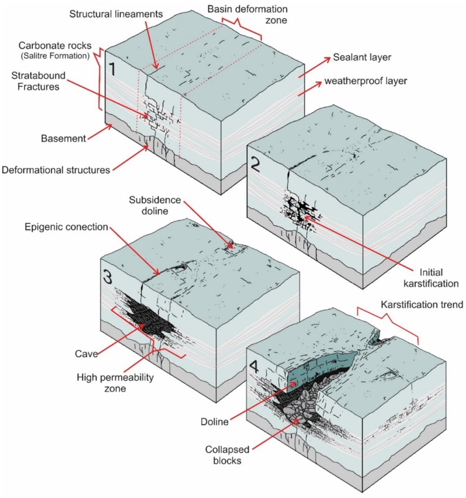
Dolines are a widespread karst landform, and understanding their genesis can provide critical information about the evolution of subsurface karstification and groundwater flow zones. Swarms of collapse dolines characterise the karst in the southern portion of the Irecê Basin, northeastern Brazil. The basin comprises Neoproterozoic carbonate rocks approximately 100 m thick, bounded by less soluble older quartzites. The distribution of dolines is not uniform, as they cluster along NW-SE axes and are aligned with cave systems and permeability (fracture) corridors mostly associated with the Almas and Água de Rega ephemeral rivers. Detailed analysis of sectors with a higher density of dolines was performed using LiDAR and unmanned aerial vehicle (UAV) imagery at two different scales to obtain morphometric and orientation patterns. As expected, scale dependency is observed, with an increase in density and circularity index at a higher resolution scale, but a decrease in mean area and perimeter. However, Voronoi polygon indices are similar at both scales (6.86 ± 1); the departure from the more stable number of six due to the clustering of dolines associated with NW-SE oriented structural trends. Doline density trends closely follow the orientation of caves, but they are not always spatially connected, since doline evolution may either occlude the caves or be related to a non-identified void. The Irecê Basin karst system displays a continuum of landforms evolving initially from high-density fracture zones (fracture corridors), which work as favourable dissolution zones, grading into more integrated flow routes, cave systems and eventually clusters of collapse dolines. Collapse dolines are widespread karst landforms worldwide, and their genesis requires the presence of dissolution voids at depth, which may pass undetected from the surface. In some sectors of Irecê Basin, the existence of doline alignments but the absence of known caves indicates the potential of collapse dolines to be used as proxies for subsurface karstification. Such an approach may allow the prediction of the location and orientation of subsurface zones of enhanced dissolution that can potentially represent productive aquifers or favourable zones for geofluids.
期刊介绍:
Earth Surface Processes and Landforms is an interdisciplinary international journal concerned with:
the interactions between surface processes and landforms and landscapes;
that lead to physical, chemical and biological changes; and which in turn create;
current landscapes and the geological record of past landscapes.
Its focus is core to both physical geographical and geological communities, and also the wider geosciences

 求助内容:
求助内容: 应助结果提醒方式:


