{"title":"确定城市增长的方法基准:土耳其埃斯基谢希尔的时空预测","authors":"Oznur Isinkaralar","doi":"10.1007/s12061-024-09592-9","DOIUrl":null,"url":null,"abstract":"<div><p>Urban growth changes spatial uses over time due to different dynamics. These processes cause many physical, environmental, and socioeconomic problems, such as climate change, pollution, and population-related events. Therefore, it is essential to predict future urban expansion to produce effective policies in sustainable urban planning and make long-term plans. Many models, such as dynamic, statistical, and Cellular Automata and Markov Chain (CA-MC) models, are used in geographic information system (GIS) environments to meet the high-performance requirements of land use modeling. This study estimated the growth of settled areas in Eskişehir city center using models developed using two different methods. In this context, settled areas in the city center were examined within the scope of 1990–2018, and the growth areas of settled areas in 2046 were predicted using the CA-Markov method in Model 1: Quantum GIS (QGIS) MOLUSCE plugin and Model 2: IDRISI Selva. While settled areas are continuously increasing, other urban areas are decreasing. Model 1 predicts an increase of 1195 ha in settled areas by 2046, while Model 2 predicts an increase of 45,022 ha. At the same time, it is concluded that settled areas will grow in a central location in Model 1, while they will spread in an east-west extension in Model 2. The study results show that QGIS-based modeling predicts more limited spatial growth than IDRISI Selva. The research interprets growth in terms of the staging of urban services, the population size of neighboring cities, distances, and income levels based on the internal and external dynamics of the city.</p></div>","PeriodicalId":46392,"journal":{"name":"Applied Spatial Analysis and Policy","volume":"17 4","pages":"1485 - 1495"},"PeriodicalIF":1.9000,"publicationDate":"2024-08-10","publicationTypes":"Journal Article","fieldsOfStudy":null,"isOpenAccess":false,"openAccessPdf":"https://link.springer.com/content/pdf/10.1007/s12061-024-09592-9.pdf","citationCount":"0","resultStr":"{\"title\":\"A Methodological Benchmark in Determining the Urban Growth: Spatiotemporal Projections for Eskişehir, Türkiye\",\"authors\":\"Oznur Isinkaralar\",\"doi\":\"10.1007/s12061-024-09592-9\",\"DOIUrl\":null,\"url\":null,\"abstract\":\"<div><p>Urban growth changes spatial uses over time due to different dynamics. These processes cause many physical, environmental, and socioeconomic problems, such as climate change, pollution, and population-related events. Therefore, it is essential to predict future urban expansion to produce effective policies in sustainable urban planning and make long-term plans. Many models, such as dynamic, statistical, and Cellular Automata and Markov Chain (CA-MC) models, are used in geographic information system (GIS) environments to meet the high-performance requirements of land use modeling. This study estimated the growth of settled areas in Eskişehir city center using models developed using two different methods. In this context, settled areas in the city center were examined within the scope of 1990–2018, and the growth areas of settled areas in 2046 were predicted using the CA-Markov method in Model 1: Quantum GIS (QGIS) MOLUSCE plugin and Model 2: IDRISI Selva. While settled areas are continuously increasing, other urban areas are decreasing. Model 1 predicts an increase of 1195 ha in settled areas by 2046, while Model 2 predicts an increase of 45,022 ha. At the same time, it is concluded that settled areas will grow in a central location in Model 1, while they will spread in an east-west extension in Model 2. The study results show that QGIS-based modeling predicts more limited spatial growth than IDRISI Selva. The research interprets growth in terms of the staging of urban services, the population size of neighboring cities, distances, and income levels based on the internal and external dynamics of the city.</p></div>\",\"PeriodicalId\":46392,\"journal\":{\"name\":\"Applied Spatial Analysis and Policy\",\"volume\":\"17 4\",\"pages\":\"1485 - 1495\"},\"PeriodicalIF\":1.9000,\"publicationDate\":\"2024-08-10\",\"publicationTypes\":\"Journal Article\",\"fieldsOfStudy\":null,\"isOpenAccess\":false,\"openAccessPdf\":\"https://link.springer.com/content/pdf/10.1007/s12061-024-09592-9.pdf\",\"citationCount\":\"0\",\"resultStr\":null,\"platform\":\"Semanticscholar\",\"paperid\":null,\"PeriodicalName\":\"Applied Spatial Analysis and Policy\",\"FirstCategoryId\":\"90\",\"ListUrlMain\":\"https://link.springer.com/article/10.1007/s12061-024-09592-9\",\"RegionNum\":4,\"RegionCategory\":\"社会学\",\"ArticlePicture\":[],\"TitleCN\":null,\"AbstractTextCN\":null,\"PMCID\":null,\"EPubDate\":\"\",\"PubModel\":\"\",\"JCR\":\"Q3\",\"JCRName\":\"ENVIRONMENTAL STUDIES\",\"Score\":null,\"Total\":0}","platform":"Semanticscholar","paperid":null,"PeriodicalName":"Applied Spatial Analysis and Policy","FirstCategoryId":"90","ListUrlMain":"https://link.springer.com/article/10.1007/s12061-024-09592-9","RegionNum":4,"RegionCategory":"社会学","ArticlePicture":[],"TitleCN":null,"AbstractTextCN":null,"PMCID":null,"EPubDate":"","PubModel":"","JCR":"Q3","JCRName":"ENVIRONMENTAL STUDIES","Score":null,"Total":0}
A Methodological Benchmark in Determining the Urban Growth: Spatiotemporal Projections for Eskişehir, Türkiye
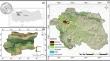
Urban growth changes spatial uses over time due to different dynamics. These processes cause many physical, environmental, and socioeconomic problems, such as climate change, pollution, and population-related events. Therefore, it is essential to predict future urban expansion to produce effective policies in sustainable urban planning and make long-term plans. Many models, such as dynamic, statistical, and Cellular Automata and Markov Chain (CA-MC) models, are used in geographic information system (GIS) environments to meet the high-performance requirements of land use modeling. This study estimated the growth of settled areas in Eskişehir city center using models developed using two different methods. In this context, settled areas in the city center were examined within the scope of 1990–2018, and the growth areas of settled areas in 2046 were predicted using the CA-Markov method in Model 1: Quantum GIS (QGIS) MOLUSCE plugin and Model 2: IDRISI Selva. While settled areas are continuously increasing, other urban areas are decreasing. Model 1 predicts an increase of 1195 ha in settled areas by 2046, while Model 2 predicts an increase of 45,022 ha. At the same time, it is concluded that settled areas will grow in a central location in Model 1, while they will spread in an east-west extension in Model 2. The study results show that QGIS-based modeling predicts more limited spatial growth than IDRISI Selva. The research interprets growth in terms of the staging of urban services, the population size of neighboring cities, distances, and income levels based on the internal and external dynamics of the city.
期刊介绍:
Description
The journal has an applied focus: it actively promotes the importance of geographical research in real world settings
It is policy-relevant: it seeks both a readership and contributions from practitioners as well as academics
The substantive foundation is spatial analysis: the use of quantitative techniques to identify patterns and processes within geographic environments
The combination of these points, which are fully reflected in the naming of the journal, establishes a unique position in the marketplace.
RationaleA geographical perspective has always been crucial to the understanding of the social and physical organisation of the world around us. The techniques of spatial analysis provide a powerful means for the assembly and interpretation of evidence, and thus to address critical questions about issues such as crime and deprivation, immigration and demographic restructuring, retailing activity and employment change, resource management and environmental improvement. Many of these issues are equally important to academic research as they are to policy makers and Applied Spatial Analysis and Policy aims to close the gap between these two perspectives by providing a forum for discussion of applied research in a range of different contexts
Topical and interdisciplinaryIncreasingly government organisations, administrative agencies and private businesses are requiring research to support their ‘evidence-based’ strategies or policies. Geographical location is critical in much of this work which extends across a wide range of disciplines including demography, actuarial sciences, statistics, public sector planning, business planning, economics, epidemiology, sociology, social policy, health research, environmental management.
FocusApplied Spatial Analysis and Policy will draw on applied research from diverse problem domains, such as transport, policing, education, health, environment and leisure, in different international contexts. The journal will therefore provide insights into the variations in phenomena that exist across space, it will provide evidence for comparative policy analysis between domains and between locations, and stimulate ideas about the translation of spatial analysis methods and techniques across varied policy contexts. It is essential to know how to measure, monitor and understand spatial distributions, many of which have implications for those with responsibility to plan and enhance the society and the environment in which we all exist.
Readership and Editorial BoardAs a journal focused on applications of methods of spatial analysis, Applied Spatial Analysis and Policy will be of interest to scholars and students in a wide range of academic fields, to practitioners in government and administrative agencies and to consultants in private sector organisations. The Editorial Board reflects the international and multidisciplinary nature of the journal.

 求助内容:
求助内容: 应助结果提醒方式:


