{"title":"多传感器卫星数据用于破译非洲乍得奥伦加撞击结构中的埋藏线状异常现象","authors":"Mohammed Sultan Alshayef, A P Pradeepkumar","doi":"10.1007/s12040-024-02365-5","DOIUrl":null,"url":null,"abstract":"<p>Deciphering geological phenomena, including planetary evolution, is accomplished by studying Earth’s impact craters. An attempt has been made to identify the buried lineament anomalies using multisensor satellite data in the Aorounga impact structure in Chad, Africa. In order to improve the visibility of buried lineaments, interferometric synthetic aperture radar (InSAR) coherence, backscatter coefficient, land surface temperature (LST), and digital elevation model (DEM) were processed. The analysis of InSAR coherence data reveals that coherence values are low to moderate in disparate regions encompassed by dune systems with rocks and higher in monotonous areas like dynamic dunes and fractured rock exposures. The results show that backscattering coefficient values of VV and VH polarization decreased in buried lineament regions covered by dunes, whereas high backscattering is experienced in regions encompassed by rocks. It was observed that nighttime has the highest LST in the linear features, whereas daytime LST is found to be low in buried lineaments regions. Thus, in this study, the backscatter coefficient of VH and VV polarization and DEM give promising interpretations to other methods for identifying buried lineament features. The study has demonstrated the potential of multisensor satellite data for identifying buried lineament anomalies that could be potential sources of groundwater, minerals, and hydrothermal activity. These anomalies may also be indicators of tectonic and structural activities.</p>","PeriodicalId":15609,"journal":{"name":"Journal of Earth System Science","volume":"44 1","pages":""},"PeriodicalIF":1.7000,"publicationDate":"2024-07-29","publicationTypes":"Journal Article","fieldsOfStudy":null,"isOpenAccess":false,"openAccessPdf":"","citationCount":"0","resultStr":"{\"title\":\"Multisensor satellite data for deciphering buried lineament anomalies in Aorounga impact structure, Chad, Africa\",\"authors\":\"Mohammed Sultan Alshayef, A P Pradeepkumar\",\"doi\":\"10.1007/s12040-024-02365-5\",\"DOIUrl\":null,\"url\":null,\"abstract\":\"<p>Deciphering geological phenomena, including planetary evolution, is accomplished by studying Earth’s impact craters. An attempt has been made to identify the buried lineament anomalies using multisensor satellite data in the Aorounga impact structure in Chad, Africa. In order to improve the visibility of buried lineaments, interferometric synthetic aperture radar (InSAR) coherence, backscatter coefficient, land surface temperature (LST), and digital elevation model (DEM) were processed. The analysis of InSAR coherence data reveals that coherence values are low to moderate in disparate regions encompassed by dune systems with rocks and higher in monotonous areas like dynamic dunes and fractured rock exposures. The results show that backscattering coefficient values of VV and VH polarization decreased in buried lineament regions covered by dunes, whereas high backscattering is experienced in regions encompassed by rocks. It was observed that nighttime has the highest LST in the linear features, whereas daytime LST is found to be low in buried lineaments regions. Thus, in this study, the backscatter coefficient of VH and VV polarization and DEM give promising interpretations to other methods for identifying buried lineament features. The study has demonstrated the potential of multisensor satellite data for identifying buried lineament anomalies that could be potential sources of groundwater, minerals, and hydrothermal activity. These anomalies may also be indicators of tectonic and structural activities.</p>\",\"PeriodicalId\":15609,\"journal\":{\"name\":\"Journal of Earth System Science\",\"volume\":\"44 1\",\"pages\":\"\"},\"PeriodicalIF\":1.7000,\"publicationDate\":\"2024-07-29\",\"publicationTypes\":\"Journal Article\",\"fieldsOfStudy\":null,\"isOpenAccess\":false,\"openAccessPdf\":\"\",\"citationCount\":\"0\",\"resultStr\":null,\"platform\":\"Semanticscholar\",\"paperid\":null,\"PeriodicalName\":\"Journal of Earth System Science\",\"FirstCategoryId\":\"89\",\"ListUrlMain\":\"https://doi.org/10.1007/s12040-024-02365-5\",\"RegionNum\":4,\"RegionCategory\":\"地球科学\",\"ArticlePicture\":[],\"TitleCN\":null,\"AbstractTextCN\":null,\"PMCID\":null,\"EPubDate\":\"\",\"PubModel\":\"\",\"JCR\":\"Q3\",\"JCRName\":\"GEOSCIENCES, MULTIDISCIPLINARY\",\"Score\":null,\"Total\":0}","platform":"Semanticscholar","paperid":null,"PeriodicalName":"Journal of Earth System Science","FirstCategoryId":"89","ListUrlMain":"https://doi.org/10.1007/s12040-024-02365-5","RegionNum":4,"RegionCategory":"地球科学","ArticlePicture":[],"TitleCN":null,"AbstractTextCN":null,"PMCID":null,"EPubDate":"","PubModel":"","JCR":"Q3","JCRName":"GEOSCIENCES, MULTIDISCIPLINARY","Score":null,"Total":0}
Multisensor satellite data for deciphering buried lineament anomalies in Aorounga impact structure, Chad, Africa
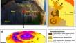
Deciphering geological phenomena, including planetary evolution, is accomplished by studying Earth’s impact craters. An attempt has been made to identify the buried lineament anomalies using multisensor satellite data in the Aorounga impact structure in Chad, Africa. In order to improve the visibility of buried lineaments, interferometric synthetic aperture radar (InSAR) coherence, backscatter coefficient, land surface temperature (LST), and digital elevation model (DEM) were processed. The analysis of InSAR coherence data reveals that coherence values are low to moderate in disparate regions encompassed by dune systems with rocks and higher in monotonous areas like dynamic dunes and fractured rock exposures. The results show that backscattering coefficient values of VV and VH polarization decreased in buried lineament regions covered by dunes, whereas high backscattering is experienced in regions encompassed by rocks. It was observed that nighttime has the highest LST in the linear features, whereas daytime LST is found to be low in buried lineaments regions. Thus, in this study, the backscatter coefficient of VH and VV polarization and DEM give promising interpretations to other methods for identifying buried lineament features. The study has demonstrated the potential of multisensor satellite data for identifying buried lineament anomalies that could be potential sources of groundwater, minerals, and hydrothermal activity. These anomalies may also be indicators of tectonic and structural activities.
期刊介绍:
The Journal of Earth System Science, an International Journal, was earlier a part of the Proceedings of the Indian Academy of Sciences – Section A begun in 1934, and later split in 1978 into theme journals. This journal was published as Proceedings – Earth and Planetary Sciences since 1978, and in 2005 was renamed ‘Journal of Earth System Science’.
The journal is highly inter-disciplinary and publishes scholarly research – new data, ideas, and conceptual advances – in Earth System Science. The focus is on the evolution of the Earth as a system: manuscripts describing changes of anthropogenic origin in a limited region are not considered unless they go beyond describing the changes to include an analysis of earth-system processes. The journal''s scope includes the solid earth (geosphere), the atmosphere, the hydrosphere (including cryosphere), and the biosphere; it also addresses related aspects of planetary and space sciences. Contributions pertaining to the Indian sub- continent and the surrounding Indian-Ocean region are particularly welcome. Given that a large number of manuscripts report either observations or model results for a limited domain, manuscripts intended for publication in JESS are expected to fulfill at least one of the following three criteria.
The data should be of relevance and should be of statistically significant size and from a region from where such data are sparse. If the data are from a well-sampled region, the data size should be considerable and advance our knowledge of the region.
A model study is carried out to explain observations reported either in the same manuscript or in the literature.
The analysis, whether of data or with models, is novel and the inferences advance the current knowledge.
 求助内容:
求助内容: 应助结果提醒方式:


