{"title":"从哨兵-2 时间序列图像中探测坝后沙洲的三维动态:澜沧江-湄公河下游案例研究","authors":"Xiaoyang Li, Hui Fan, Ting Yang","doi":"10.1002/esp.5918","DOIUrl":null,"url":null,"abstract":"<p>Channel sandbars are extremely sensitive to basin-wide natural processes and human activities, and their modifications considerably affect channel stability and river ecosystem health. However, quantitatively detecting the three-dimensional dynamics of channel sandbars at a high spatial resolution over a large area remains challenging. In this study, we propose a semi-automated process to address this challenge by extracting sandbar contours from Sentinel-2 images in the Google Earth Engine (GEE) platform. We then generate contour datasets for each sandbar based on the spatial relationship between contours and water levels at nearby hydrological stations. Subsequently, digital elevation models (DEMs) are created for each sandbar using the contour dataset, and non-linear relations between sandbar areas and water levels are fitted through polynomial curves of degrees 3–6 to calculate changes in sandbar volumes. Finally, we comprehensively analysed the driving mechanisms of sandbar changes in different sub-reaches. Our findings reveal the area and volume of sandbars in three of the four sub-reaches increased significantly between 2018 and 2019; however, these values decreased significantly and continuously between 2019 and 2022. Sandbars located downstream near the dam experienced more severe erosion compared to those farther downstream. Although the morphodynamic processes of each sub-reach were different, extremely low rainfall in 2019–2020 and the operation of the Xayaburi Dam are significant global factors leading to the shrinkage of the sandbars. Furthermore, abnormal erosion with a change rate of −9.62% in area and −8.95% in volume was observed in the sub-reach between Vientiane and Khong Chiam hydrological stations between 2018 and 2019, with the susceptibility of the channel to flow scour and anthropogenic sand mining being significant factors. Although the sediment replenishment from tributaries diminishes the impact of upstream dams and droughts on the reach farther downstream, the threat to channel stability due to excessive sand mining should be given high priority. Our study highlights how satellite remote sensing, specifically utilizing time series images with fine spatio-temporal resolutions, effectively detects three-dimensional variations in sandbars and river geomorphic changes. Additionally, it demonstrates the significant post-dam alteration of erosion patterns and deposition dynamics within the sandbar region of the lower Mekong River.</p>","PeriodicalId":11408,"journal":{"name":"Earth Surface Processes and Landforms","volume":"49 11","pages":"3489-3509"},"PeriodicalIF":2.8000,"publicationDate":"2024-07-26","publicationTypes":"Journal Article","fieldsOfStudy":null,"isOpenAccess":false,"openAccessPdf":"","citationCount":"0","resultStr":"{\"title\":\"Detecting the three-dimensional dynamics of post-dam sandbars from Sentinel-2 time-series images: A case study in the lower Lancang–Mekong River\",\"authors\":\"Xiaoyang Li, Hui Fan, Ting Yang\",\"doi\":\"10.1002/esp.5918\",\"DOIUrl\":null,\"url\":null,\"abstract\":\"<p>Channel sandbars are extremely sensitive to basin-wide natural processes and human activities, and their modifications considerably affect channel stability and river ecosystem health. However, quantitatively detecting the three-dimensional dynamics of channel sandbars at a high spatial resolution over a large area remains challenging. In this study, we propose a semi-automated process to address this challenge by extracting sandbar contours from Sentinel-2 images in the Google Earth Engine (GEE) platform. We then generate contour datasets for each sandbar based on the spatial relationship between contours and water levels at nearby hydrological stations. Subsequently, digital elevation models (DEMs) are created for each sandbar using the contour dataset, and non-linear relations between sandbar areas and water levels are fitted through polynomial curves of degrees 3–6 to calculate changes in sandbar volumes. Finally, we comprehensively analysed the driving mechanisms of sandbar changes in different sub-reaches. Our findings reveal the area and volume of sandbars in three of the four sub-reaches increased significantly between 2018 and 2019; however, these values decreased significantly and continuously between 2019 and 2022. Sandbars located downstream near the dam experienced more severe erosion compared to those farther downstream. Although the morphodynamic processes of each sub-reach were different, extremely low rainfall in 2019–2020 and the operation of the Xayaburi Dam are significant global factors leading to the shrinkage of the sandbars. Furthermore, abnormal erosion with a change rate of −9.62% in area and −8.95% in volume was observed in the sub-reach between Vientiane and Khong Chiam hydrological stations between 2018 and 2019, with the susceptibility of the channel to flow scour and anthropogenic sand mining being significant factors. Although the sediment replenishment from tributaries diminishes the impact of upstream dams and droughts on the reach farther downstream, the threat to channel stability due to excessive sand mining should be given high priority. Our study highlights how satellite remote sensing, specifically utilizing time series images with fine spatio-temporal resolutions, effectively detects three-dimensional variations in sandbars and river geomorphic changes. Additionally, it demonstrates the significant post-dam alteration of erosion patterns and deposition dynamics within the sandbar region of the lower Mekong River.</p>\",\"PeriodicalId\":11408,\"journal\":{\"name\":\"Earth Surface Processes and Landforms\",\"volume\":\"49 11\",\"pages\":\"3489-3509\"},\"PeriodicalIF\":2.8000,\"publicationDate\":\"2024-07-26\",\"publicationTypes\":\"Journal Article\",\"fieldsOfStudy\":null,\"isOpenAccess\":false,\"openAccessPdf\":\"\",\"citationCount\":\"0\",\"resultStr\":null,\"platform\":\"Semanticscholar\",\"paperid\":null,\"PeriodicalName\":\"Earth Surface Processes and Landforms\",\"FirstCategoryId\":\"89\",\"ListUrlMain\":\"https://onlinelibrary.wiley.com/doi/10.1002/esp.5918\",\"RegionNum\":3,\"RegionCategory\":\"地球科学\",\"ArticlePicture\":[],\"TitleCN\":null,\"AbstractTextCN\":null,\"PMCID\":null,\"EPubDate\":\"\",\"PubModel\":\"\",\"JCR\":\"Q2\",\"JCRName\":\"GEOGRAPHY, PHYSICAL\",\"Score\":null,\"Total\":0}","platform":"Semanticscholar","paperid":null,"PeriodicalName":"Earth Surface Processes and Landforms","FirstCategoryId":"89","ListUrlMain":"https://onlinelibrary.wiley.com/doi/10.1002/esp.5918","RegionNum":3,"RegionCategory":"地球科学","ArticlePicture":[],"TitleCN":null,"AbstractTextCN":null,"PMCID":null,"EPubDate":"","PubModel":"","JCR":"Q2","JCRName":"GEOGRAPHY, PHYSICAL","Score":null,"Total":0}
Detecting the three-dimensional dynamics of post-dam sandbars from Sentinel-2 time-series images: A case study in the lower Lancang–Mekong River
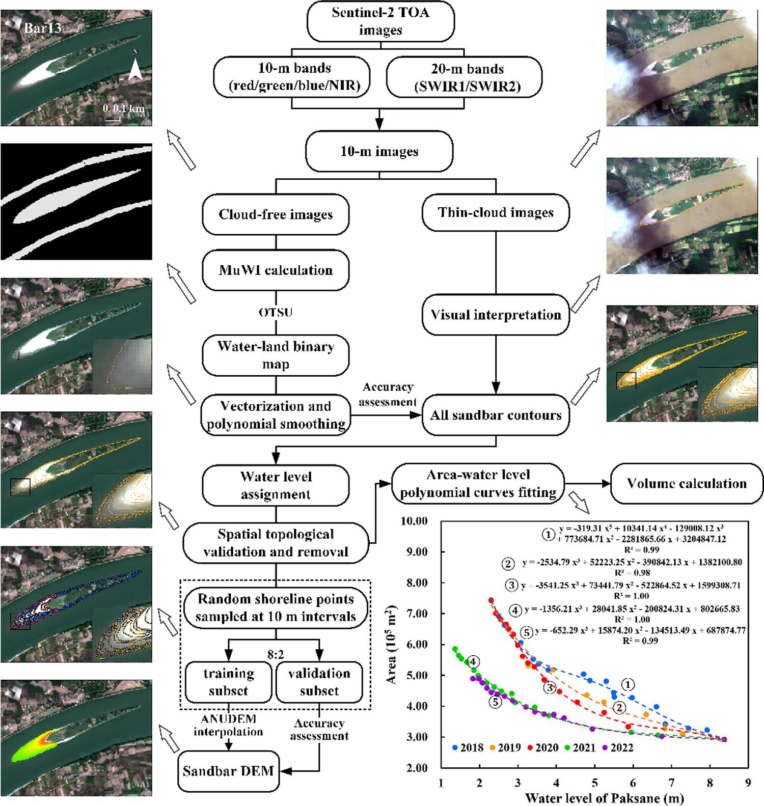
Channel sandbars are extremely sensitive to basin-wide natural processes and human activities, and their modifications considerably affect channel stability and river ecosystem health. However, quantitatively detecting the three-dimensional dynamics of channel sandbars at a high spatial resolution over a large area remains challenging. In this study, we propose a semi-automated process to address this challenge by extracting sandbar contours from Sentinel-2 images in the Google Earth Engine (GEE) platform. We then generate contour datasets for each sandbar based on the spatial relationship between contours and water levels at nearby hydrological stations. Subsequently, digital elevation models (DEMs) are created for each sandbar using the contour dataset, and non-linear relations between sandbar areas and water levels are fitted through polynomial curves of degrees 3–6 to calculate changes in sandbar volumes. Finally, we comprehensively analysed the driving mechanisms of sandbar changes in different sub-reaches. Our findings reveal the area and volume of sandbars in three of the four sub-reaches increased significantly between 2018 and 2019; however, these values decreased significantly and continuously between 2019 and 2022. Sandbars located downstream near the dam experienced more severe erosion compared to those farther downstream. Although the morphodynamic processes of each sub-reach were different, extremely low rainfall in 2019–2020 and the operation of the Xayaburi Dam are significant global factors leading to the shrinkage of the sandbars. Furthermore, abnormal erosion with a change rate of −9.62% in area and −8.95% in volume was observed in the sub-reach between Vientiane and Khong Chiam hydrological stations between 2018 and 2019, with the susceptibility of the channel to flow scour and anthropogenic sand mining being significant factors. Although the sediment replenishment from tributaries diminishes the impact of upstream dams and droughts on the reach farther downstream, the threat to channel stability due to excessive sand mining should be given high priority. Our study highlights how satellite remote sensing, specifically utilizing time series images with fine spatio-temporal resolutions, effectively detects three-dimensional variations in sandbars and river geomorphic changes. Additionally, it demonstrates the significant post-dam alteration of erosion patterns and deposition dynamics within the sandbar region of the lower Mekong River.
期刊介绍:
Earth Surface Processes and Landforms is an interdisciplinary international journal concerned with:
the interactions between surface processes and landforms and landscapes;
that lead to physical, chemical and biological changes; and which in turn create;
current landscapes and the geological record of past landscapes.
Its focus is core to both physical geographical and geological communities, and also the wider geosciences

 求助内容:
求助内容: 应助结果提醒方式:


