Xiaopeng Zhou, Jianhui Deng, Siyuan Zhao, Hua Li, Haonan Cui, Chenglin Ye, Wanyu Hu
{"title":"巨型措拉滑坡坝的形成和溃决及其对西藏东南部金沙江河谷地貌演变的影响","authors":"Xiaopeng Zhou, Jianhui Deng, Siyuan Zhao, Hua Li, Haonan Cui, Chenglin Ye, Wanyu Hu","doi":"10.1007/s10346-024-02318-5","DOIUrl":null,"url":null,"abstract":"<p>The giant Cuola landslide is one of the largest and highest landslide dams in the upper reaches of the Jinsha River, which brought about a substantial influence on the geomorphological evolution of the Jinsha River valley. Through field investigations, UAV photogrammetry, OSL, and <sup>10</sup>Be dating methods, the topographic and geological characteristics of the Cuola landslide dam were examined, and the evolution features of formation and failure were investigated as well. The results indicate that the Cuola landslide, with a volume of ~ 4 × 10<sup>8</sup> m<sup>3</sup> and an age of ~ 50.9 ka BP, was primarily due to a seismic event, and the major failure mode of the ~ 1590-m-high source area on the left bank was attributable to a wedge sliding. The landslide body slid into the valley and climbed ~ 540 m up the right bank with a long runout of 3740 m. The relict landslide deposits demonstrate a large-scale natural dam with a height of 272 m, a length of 1780 m, and a width of 1940 m, which completely blocked the river, and formed a dammed lake with an inundation length of 190 km and an impoundment volume of 10.817 km<sup>3</sup>. The longevity of the landslide dam was discussed in terms of glacial climate, dam morphology, and material characteristics, and fault dislocation was deduced to induce the overtopping dam break at ~ 4 ka BP. The overflowing water preferentially undercut the weak zone created by fault displacement within the dam until the onset of the final breach, facilitated by the warm climatic conditions of Holocene Climatic Optimum. The findings in this study illustrate the dramatic longevity of a natural dam produced by a giant landslide in one of the most deeply incised valleys in the world and provide a conceptual model for a better understanding of landslide-induced landscape evolution of high-relief river catchments.\n</p>","PeriodicalId":17938,"journal":{"name":"Landslides","volume":"34 1","pages":""},"PeriodicalIF":7.0000,"publicationDate":"2024-07-19","publicationTypes":"Journal Article","fieldsOfStudy":null,"isOpenAccess":false,"openAccessPdf":"","citationCount":"0","resultStr":"{\"title\":\"Formation and breach of the giant Cuola landslide dam and their impacts on the landscape evolution of river valley in the Jinsha River, southeastern Tibet\",\"authors\":\"Xiaopeng Zhou, Jianhui Deng, Siyuan Zhao, Hua Li, Haonan Cui, Chenglin Ye, Wanyu Hu\",\"doi\":\"10.1007/s10346-024-02318-5\",\"DOIUrl\":null,\"url\":null,\"abstract\":\"<p>The giant Cuola landslide is one of the largest and highest landslide dams in the upper reaches of the Jinsha River, which brought about a substantial influence on the geomorphological evolution of the Jinsha River valley. Through field investigations, UAV photogrammetry, OSL, and <sup>10</sup>Be dating methods, the topographic and geological characteristics of the Cuola landslide dam were examined, and the evolution features of formation and failure were investigated as well. The results indicate that the Cuola landslide, with a volume of ~ 4 × 10<sup>8</sup> m<sup>3</sup> and an age of ~ 50.9 ka BP, was primarily due to a seismic event, and the major failure mode of the ~ 1590-m-high source area on the left bank was attributable to a wedge sliding. The landslide body slid into the valley and climbed ~ 540 m up the right bank with a long runout of 3740 m. The relict landslide deposits demonstrate a large-scale natural dam with a height of 272 m, a length of 1780 m, and a width of 1940 m, which completely blocked the river, and formed a dammed lake with an inundation length of 190 km and an impoundment volume of 10.817 km<sup>3</sup>. The longevity of the landslide dam was discussed in terms of glacial climate, dam morphology, and material characteristics, and fault dislocation was deduced to induce the overtopping dam break at ~ 4 ka BP. The overflowing water preferentially undercut the weak zone created by fault displacement within the dam until the onset of the final breach, facilitated by the warm climatic conditions of Holocene Climatic Optimum. The findings in this study illustrate the dramatic longevity of a natural dam produced by a giant landslide in one of the most deeply incised valleys in the world and provide a conceptual model for a better understanding of landslide-induced landscape evolution of high-relief river catchments.\\n</p>\",\"PeriodicalId\":17938,\"journal\":{\"name\":\"Landslides\",\"volume\":\"34 1\",\"pages\":\"\"},\"PeriodicalIF\":7.0000,\"publicationDate\":\"2024-07-19\",\"publicationTypes\":\"Journal Article\",\"fieldsOfStudy\":null,\"isOpenAccess\":false,\"openAccessPdf\":\"\",\"citationCount\":\"0\",\"resultStr\":null,\"platform\":\"Semanticscholar\",\"paperid\":null,\"PeriodicalName\":\"Landslides\",\"FirstCategoryId\":\"89\",\"ListUrlMain\":\"https://doi.org/10.1007/s10346-024-02318-5\",\"RegionNum\":2,\"RegionCategory\":\"工程技术\",\"ArticlePicture\":[],\"TitleCN\":null,\"AbstractTextCN\":null,\"PMCID\":null,\"EPubDate\":\"\",\"PubModel\":\"\",\"JCR\":\"Q1\",\"JCRName\":\"ENGINEERING, GEOLOGICAL\",\"Score\":null,\"Total\":0}","platform":"Semanticscholar","paperid":null,"PeriodicalName":"Landslides","FirstCategoryId":"89","ListUrlMain":"https://doi.org/10.1007/s10346-024-02318-5","RegionNum":2,"RegionCategory":"工程技术","ArticlePicture":[],"TitleCN":null,"AbstractTextCN":null,"PMCID":null,"EPubDate":"","PubModel":"","JCR":"Q1","JCRName":"ENGINEERING, GEOLOGICAL","Score":null,"Total":0}
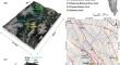
Formation and breach of the giant Cuola landslide dam and their impacts on the landscape evolution of river valley in the Jinsha River, southeastern Tibet
The giant Cuola landslide is one of the largest and highest landslide dams in the upper reaches of the Jinsha River, which brought about a substantial influence on the geomorphological evolution of the Jinsha River valley. Through field investigations, UAV photogrammetry, OSL, and 10Be dating methods, the topographic and geological characteristics of the Cuola landslide dam were examined, and the evolution features of formation and failure were investigated as well. The results indicate that the Cuola landslide, with a volume of ~ 4 × 10⁸ m3 and an age of ~ 50.9 ka BP, was primarily due to a seismic event, and the major failure mode of the ~ 1590-m-high source area on the left bank was attributable to a wedge sliding. The landslide body slid into the valley and climbed ~ 540 m up the right bank with a long runout of 3740 m. The relict landslide deposits demonstrate a large-scale natural dam with a height of 272 m, a length of 1780 m, and a width of 1940 m, which completely blocked the river, and formed a dammed lake with an inundation length of 190 km and an impoundment volume of 10.817 km3. The longevity of the landslide dam was discussed in terms of glacial climate, dam morphology, and material characteristics, and fault dislocation was deduced to induce the overtopping dam break at ~ 4 ka BP. The overflowing water preferentially undercut the weak zone created by fault displacement within the dam until the onset of the final breach, facilitated by the warm climatic conditions of Holocene Climatic Optimum. The findings in this study illustrate the dramatic longevity of a natural dam produced by a giant landslide in one of the most deeply incised valleys in the world and provide a conceptual model for a better understanding of landslide-induced landscape evolution of high-relief river catchments.
期刊介绍:
Landslides are gravitational mass movements of rock, debris or earth. They may occur in conjunction with other major natural disasters such as floods, earthquakes and volcanic eruptions. Expanding urbanization and changing land-use practices have increased the incidence of landslide disasters. Landslides as catastrophic events include human injury, loss of life and economic devastation and are studied as part of the fields of earth, water and engineering sciences. The aim of the journal Landslides is to be the common platform for the publication of integrated research on landslide processes, hazards, risk analysis, mitigation, and the protection of our cultural heritage and the environment. The journal publishes research papers, news of recent landslide events and information on the activities of the International Consortium on Landslides.
- Landslide dynamics, mechanisms and processes
- Landslide risk evaluation: hazard assessment, hazard mapping, and vulnerability assessment
- Geological, Geotechnical, Hydrological and Geophysical modeling
- Effects of meteorological, hydrological and global climatic change factors
- Monitoring including remote sensing and other non-invasive systems
- New technology, expert and intelligent systems
- Application of GIS techniques
- Rock slides, rock falls, debris flows, earth flows, and lateral spreads
- Large-scale landslides, lahars and pyroclastic flows in volcanic zones
- Marine and reservoir related landslides
- Landslide related tsunamis and seiches
- Landslide disasters in urban areas and along critical infrastructure
- Landslides and natural resources
- Land development and land-use practices
- Landslide remedial measures / prevention works
- Temporal and spatial prediction of landslides
- Early warning and evacuation
- Global landslide database

 求助内容:
求助内容: 应助结果提醒方式:


