{"title":"通过卫星图像识别伏尔加河南岸高地的表层碳酸盐土壤和底岩多变的土壤","authors":"I. N. Gorokhova, N. B. Khitrov, L. A. Tarnopolsky","doi":"10.1134/s1064229324600763","DOIUrl":null,"url":null,"abstract":"<h3 data-test=\"abstract-sub-heading\">Abstract</h3><p>The aim of this work is to reveal correlation between the spectral characteristics of the open soil surface on the Pleiades image (April 25, 2020) and soils of a key site with a complex soil cover pattern in the south of the Volga Upland (Volga–Don irrigation system, Volgograd oblast). The study area is specified by the lithological heterogeneity: Paleogene and Neogene sands and loams are overlain by a mantle of Quaternary brown loams of variable thickness from 1–2 m to complete thinning out. The soil cover is represented by light chestnut solonetzic complexes complicated by a mosaic of lithological variants and erosion–accumulative combinations. Eight soil groups have been specified, and a map of their distribution has been developed for the key site of 343 ha with the use of digital methods of processing the spectral characteristics of the satellite image and ground-based soil information. Soil groups differ in general features of the soil surface due to differences in the contents of gravel and stones, texture of the surface horizon (from sand to silt loam), occurrence of brightened crusts, and surface effervescence depending on the thickness of the upper lithological layer. Soils with different horizonation of the profile—agrochestnut soils, agrozems, and agrosolonetzes—fall within the same groups of surface spectral characteristics; vice versa, soils of the same genetic type and, sometimes, subtype fall into different groups. This is explained by the incomplete correspondence of the properties of the soil surface affecting the spectral characteristics to the internal structure of the soil profile as a whole.</p>","PeriodicalId":11892,"journal":{"name":"Eurasian Soil Science","volume":"21 1","pages":""},"PeriodicalIF":1.6000,"publicationDate":"2024-07-22","publicationTypes":"Journal Article","fieldsOfStudy":null,"isOpenAccess":false,"openAccessPdf":"","citationCount":"0","resultStr":"{\"title\":\"Identification of Surface-Carbonate Soils and Soils with Variegated Underlying Rocks in the South of Volga Upland on Satellite Images\",\"authors\":\"I. N. Gorokhova, N. B. Khitrov, L. A. Tarnopolsky\",\"doi\":\"10.1134/s1064229324600763\",\"DOIUrl\":null,\"url\":null,\"abstract\":\"<h3 data-test=\\\"abstract-sub-heading\\\">Abstract</h3><p>The aim of this work is to reveal correlation between the spectral characteristics of the open soil surface on the Pleiades image (April 25, 2020) and soils of a key site with a complex soil cover pattern in the south of the Volga Upland (Volga–Don irrigation system, Volgograd oblast). The study area is specified by the lithological heterogeneity: Paleogene and Neogene sands and loams are overlain by a mantle of Quaternary brown loams of variable thickness from 1–2 m to complete thinning out. The soil cover is represented by light chestnut solonetzic complexes complicated by a mosaic of lithological variants and erosion–accumulative combinations. Eight soil groups have been specified, and a map of their distribution has been developed for the key site of 343 ha with the use of digital methods of processing the spectral characteristics of the satellite image and ground-based soil information. Soil groups differ in general features of the soil surface due to differences in the contents of gravel and stones, texture of the surface horizon (from sand to silt loam), occurrence of brightened crusts, and surface effervescence depending on the thickness of the upper lithological layer. Soils with different horizonation of the profile—agrochestnut soils, agrozems, and agrosolonetzes—fall within the same groups of surface spectral characteristics; vice versa, soils of the same genetic type and, sometimes, subtype fall into different groups. This is explained by the incomplete correspondence of the properties of the soil surface affecting the spectral characteristics to the internal structure of the soil profile as a whole.</p>\",\"PeriodicalId\":11892,\"journal\":{\"name\":\"Eurasian Soil Science\",\"volume\":\"21 1\",\"pages\":\"\"},\"PeriodicalIF\":1.6000,\"publicationDate\":\"2024-07-22\",\"publicationTypes\":\"Journal Article\",\"fieldsOfStudy\":null,\"isOpenAccess\":false,\"openAccessPdf\":\"\",\"citationCount\":\"0\",\"resultStr\":null,\"platform\":\"Semanticscholar\",\"paperid\":null,\"PeriodicalName\":\"Eurasian Soil Science\",\"FirstCategoryId\":\"97\",\"ListUrlMain\":\"https://doi.org/10.1134/s1064229324600763\",\"RegionNum\":4,\"RegionCategory\":\"农林科学\",\"ArticlePicture\":[],\"TitleCN\":null,\"AbstractTextCN\":null,\"PMCID\":null,\"EPubDate\":\"\",\"PubModel\":\"\",\"JCR\":\"Q4\",\"JCRName\":\"SOIL SCIENCE\",\"Score\":null,\"Total\":0}","platform":"Semanticscholar","paperid":null,"PeriodicalName":"Eurasian Soil Science","FirstCategoryId":"97","ListUrlMain":"https://doi.org/10.1134/s1064229324600763","RegionNum":4,"RegionCategory":"农林科学","ArticlePicture":[],"TitleCN":null,"AbstractTextCN":null,"PMCID":null,"EPubDate":"","PubModel":"","JCR":"Q4","JCRName":"SOIL SCIENCE","Score":null,"Total":0}
Identification of Surface-Carbonate Soils and Soils with Variegated Underlying Rocks in the South of Volga Upland on Satellite Images
Abstract
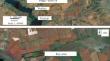
The aim of this work is to reveal correlation between the spectral characteristics of the open soil surface on the Pleiades image (April 25, 2020) and soils of a key site with a complex soil cover pattern in the south of the Volga Upland (Volga–Don irrigation system, Volgograd oblast). The study area is specified by the lithological heterogeneity: Paleogene and Neogene sands and loams are overlain by a mantle of Quaternary brown loams of variable thickness from 1–2 m to complete thinning out. The soil cover is represented by light chestnut solonetzic complexes complicated by a mosaic of lithological variants and erosion–accumulative combinations. Eight soil groups have been specified, and a map of their distribution has been developed for the key site of 343 ha with the use of digital methods of processing the spectral characteristics of the satellite image and ground-based soil information. Soil groups differ in general features of the soil surface due to differences in the contents of gravel and stones, texture of the surface horizon (from sand to silt loam), occurrence of brightened crusts, and surface effervescence depending on the thickness of the upper lithological layer. Soils with different horizonation of the profile—agrochestnut soils, agrozems, and agrosolonetzes—fall within the same groups of surface spectral characteristics; vice versa, soils of the same genetic type and, sometimes, subtype fall into different groups. This is explained by the incomplete correspondence of the properties of the soil surface affecting the spectral characteristics to the internal structure of the soil profile as a whole.
期刊介绍:
Eurasian Soil Science publishes original research papers on global and regional studies discussing both theoretical and experimental problems of genesis, geography, physics, chemistry, biology, fertility, management, conservation, and remediation of soils. Special sections are devoted to current news in the life of the International and Russian soil science societies and to the history of soil sciences.
Since 2000, the journal Agricultural Chemistry, the English version of the journal of the Russian Academy of Sciences Agrokhimiya, has been merged into the journal Eurasian Soil Science and is no longer published as a separate title.
 求助内容:
求助内容: 应助结果提醒方式:


