{"title":"巴西东南部瓜拉尼含水层系统的三维模型和环境脆弱性","authors":"","doi":"10.1016/j.gsd.2024.101285","DOIUrl":null,"url":null,"abstract":"<div><p>The Guarani Aquifer System (GAS) is a vast transboundary continental sedimentary basin in southern South America, encompassing sedimentary rocks and basalt flows across Uruguay, Paraguay, Argentina, and Brazil. It serves as a crucial water resource for urban supply and irrigation. This study aims to propose geophysical, geometric, and fragility models of the GAS in a critical exploitation area, utilizing geological data, geophysical logs, geomorphometry, and information from tubular wells. The models define distinct geophysical ranges for each formation and identify contacts between sedimentary and basaltic rocks. Integration of horizontal and vertical spatial distributions of geophysical and geological data forms a 3D model, revealing basaltic flows and intrusions distribution in fragile areas between formations, and potentially connecting aquifer layers. Natural fragility zones, characterized by high fracture densities, are observed in the central-east region, while outcrop and recharge areas of the main aquifer hydrofacies are found in the north. The 3D model highlights similarities between the topography of the Botucatu Formation (KJb – eolian sandstones) and the potentiometry of GAS at local scales, and overexploitation zones in Ribeirão Preto's city center. The assessment prioritizes areas at risk and conservation strategies for sedimentary aquifers, emphasizing interactions between surface and groundwater and addressing issues of overexploitation, identifying high-impact risks on GAS hydrodynamics and water quality.</p></div>","PeriodicalId":37879,"journal":{"name":"Groundwater for Sustainable Development","volume":null,"pages":null},"PeriodicalIF":4.9000,"publicationDate":"2024-07-18","publicationTypes":"Journal Article","fieldsOfStudy":null,"isOpenAccess":false,"openAccessPdf":"","citationCount":"0","resultStr":"{\"title\":\"Three-dimensional model and environmental fragility in the Guarani Aquifer system, SE-Brazil\",\"authors\":\"\",\"doi\":\"10.1016/j.gsd.2024.101285\",\"DOIUrl\":null,\"url\":null,\"abstract\":\"<div><p>The Guarani Aquifer System (GAS) is a vast transboundary continental sedimentary basin in southern South America, encompassing sedimentary rocks and basalt flows across Uruguay, Paraguay, Argentina, and Brazil. It serves as a crucial water resource for urban supply and irrigation. This study aims to propose geophysical, geometric, and fragility models of the GAS in a critical exploitation area, utilizing geological data, geophysical logs, geomorphometry, and information from tubular wells. The models define distinct geophysical ranges for each formation and identify contacts between sedimentary and basaltic rocks. Integration of horizontal and vertical spatial distributions of geophysical and geological data forms a 3D model, revealing basaltic flows and intrusions distribution in fragile areas between formations, and potentially connecting aquifer layers. Natural fragility zones, characterized by high fracture densities, are observed in the central-east region, while outcrop and recharge areas of the main aquifer hydrofacies are found in the north. The 3D model highlights similarities between the topography of the Botucatu Formation (KJb – eolian sandstones) and the potentiometry of GAS at local scales, and overexploitation zones in Ribeirão Preto's city center. The assessment prioritizes areas at risk and conservation strategies for sedimentary aquifers, emphasizing interactions between surface and groundwater and addressing issues of overexploitation, identifying high-impact risks on GAS hydrodynamics and water quality.</p></div>\",\"PeriodicalId\":37879,\"journal\":{\"name\":\"Groundwater for Sustainable Development\",\"volume\":null,\"pages\":null},\"PeriodicalIF\":4.9000,\"publicationDate\":\"2024-07-18\",\"publicationTypes\":\"Journal Article\",\"fieldsOfStudy\":null,\"isOpenAccess\":false,\"openAccessPdf\":\"\",\"citationCount\":\"0\",\"resultStr\":null,\"platform\":\"Semanticscholar\",\"paperid\":null,\"PeriodicalName\":\"Groundwater for Sustainable Development\",\"FirstCategoryId\":\"1085\",\"ListUrlMain\":\"https://www.sciencedirect.com/science/article/pii/S2352801X2400208X\",\"RegionNum\":0,\"RegionCategory\":null,\"ArticlePicture\":[],\"TitleCN\":null,\"AbstractTextCN\":null,\"PMCID\":null,\"EPubDate\":\"\",\"PubModel\":\"\",\"JCR\":\"Q2\",\"JCRName\":\"ENGINEERING, ENVIRONMENTAL\",\"Score\":null,\"Total\":0}","platform":"Semanticscholar","paperid":null,"PeriodicalName":"Groundwater for Sustainable Development","FirstCategoryId":"1085","ListUrlMain":"https://www.sciencedirect.com/science/article/pii/S2352801X2400208X","RegionNum":0,"RegionCategory":null,"ArticlePicture":[],"TitleCN":null,"AbstractTextCN":null,"PMCID":null,"EPubDate":"","PubModel":"","JCR":"Q2","JCRName":"ENGINEERING, ENVIRONMENTAL","Score":null,"Total":0}
引用次数: 0
摘要
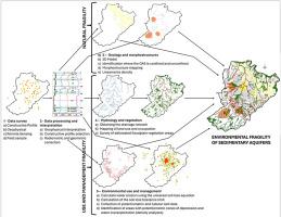
瓜拉尼含水层系统(GAS)是南美洲南部一个巨大的跨界大陆沉积盆地,包括沉积岩和玄武岩流,横跨乌拉圭、巴拉圭、阿根廷和巴西。它是城市供水和灌溉的重要水资源。本研究旨在利用地质数据、地球物理测井记录、地貌测量和管井信息,为重要开采区的 GAS 提出地球物理、几何和脆性模型。这些模型为每个岩层定义了不同的地球物理范围,并确定了沉积岩和玄武岩之间的接触点。整合地球物理和地质数据的水平和垂直空间分布,形成三维模型,揭示玄武岩流和侵入体在地层之间脆弱区域的分布情况,并可能连接含水层。在中东部地区观察到了以高断裂密度为特征的自然脆性区,而在北部则发现了主要含水层水相的露头和补给区。三维模型突出显示了博图卡图地层(KJb--风化砂岩)的地形与当地范围内的 GAS 电位测量之间的相似性,以及里贝朗普雷图市中心的过度开采区。评估确定了沉积含水层的优先风险区域和保护战略,强调了地表水和地下水之间的相互作用,解决了过度开发问题,确定了对瓦斯水动力和水质影响较大的风险。
Three-dimensional model and environmental fragility in the Guarani Aquifer system, SE-Brazil
The Guarani Aquifer System (GAS) is a vast transboundary continental sedimentary basin in southern South America, encompassing sedimentary rocks and basalt flows across Uruguay, Paraguay, Argentina, and Brazil. It serves as a crucial water resource for urban supply and irrigation. This study aims to propose geophysical, geometric, and fragility models of the GAS in a critical exploitation area, utilizing geological data, geophysical logs, geomorphometry, and information from tubular wells. The models define distinct geophysical ranges for each formation and identify contacts between sedimentary and basaltic rocks. Integration of horizontal and vertical spatial distributions of geophysical and geological data forms a 3D model, revealing basaltic flows and intrusions distribution in fragile areas between formations, and potentially connecting aquifer layers. Natural fragility zones, characterized by high fracture densities, are observed in the central-east region, while outcrop and recharge areas of the main aquifer hydrofacies are found in the north. The 3D model highlights similarities between the topography of the Botucatu Formation (KJb – eolian sandstones) and the potentiometry of GAS at local scales, and overexploitation zones in Ribeirão Preto's city center. The assessment prioritizes areas at risk and conservation strategies for sedimentary aquifers, emphasizing interactions between surface and groundwater and addressing issues of overexploitation, identifying high-impact risks on GAS hydrodynamics and water quality.
期刊介绍:
Groundwater for Sustainable Development is directed to different stakeholders and professionals, including government and non-governmental organizations, international funding agencies, universities, public water institutions, public health and other public/private sector professionals, and other relevant institutions. It is aimed at professionals, academics and students in the fields of disciplines such as: groundwater and its connection to surface hydrology and environment, soil sciences, engineering, ecology, microbiology, atmospheric sciences, analytical chemistry, hydro-engineering, water technology, environmental ethics, economics, public health, policy, as well as social sciences, legal disciplines, or any other area connected with water issues. The objectives of this journal are to facilitate: • The improvement of effective and sustainable management of water resources across the globe. • The improvement of human access to groundwater resources in adequate quantity and good quality. • The meeting of the increasing demand for drinking and irrigation water needed for food security to contribute to a social and economically sound human development. • The creation of a global inter- and multidisciplinary platform and forum to improve our understanding of groundwater resources and to advocate their effective and sustainable management and protection against contamination. • Interdisciplinary information exchange and to stimulate scientific research in the fields of groundwater related sciences and social and health sciences required to achieve the United Nations Millennium Development Goals for sustainable development.

 求助内容:
求助内容: 应助结果提醒方式:


