Falak Zahoor, Kondalamahanaty Seshagiri Rao, Neelima Satyam, Mohammad Shafi Mir
{"title":"克什米尔盆地的岩土特征和二维土壤断面模型开发","authors":"Falak Zahoor, Kondalamahanaty Seshagiri Rao, Neelima Satyam, Mohammad Shafi Mir","doi":"10.1007/s12517-024-12016-0","DOIUrl":null,"url":null,"abstract":"<div><p>An integrated analysis of the surface geology with geotechnical parameters of soils within the Kashmir Basin has been presented in this study. Spatial distribution maps of soil properties were prepared using an extensive database of Standard Penetration Test (SPT) reports at ~ 700 sites collected from geotechnical consultancies. The SPT <i>N</i> is high (~ 10–50) in the stiff, dry Pleistocene Karewas and low (< 20) in saturated Recent Alluvial deposits of the Jhelum River. These sedimentary deposits show a low plasticity index (< 17%) as well as the presence of stable clay minerals. The compression index is lower for Karewas (0.08–0.27) than for alluvium (0.16–0.36) indicating higher settlement hazard in the latter. Geological-cum-geotechnical cross-sections along seven transverse and five longitudinal transects were also developed. As an application of this study, the bearing capacity estimates, along with the liquefaction susceptibility map of the soils in the urban area of Greater Srinagar are presented. The alluvial floodplains are revealed to be critical in terms of low ultimate bearing capacity (< 300 kPa) as well as high liquefaction susceptibility (<i>L</i><sub><i>S</i></sub> > 0.8). On the other hand, Karewas show good bearing capacity (> 300 kPa) and medium liquefaction susceptibility (<i>L</i><sub><i>S</i></sub> 0.5–0.8). Based on these geotechnical aspects, Karewa highlands were found to be the most suitable for the expansion of the city and its future urbanisation. The results of this study are aimed to assist civil engineers in the proper design of structures, especially foundations, as well as to support urban planners in creating policies for town planning and expansion strategies in Kashmir.</p></div>","PeriodicalId":476,"journal":{"name":"Arabian Journal of Geosciences","volume":"17 8","pages":""},"PeriodicalIF":1.8270,"publicationDate":"2024-07-13","publicationTypes":"Journal Article","fieldsOfStudy":null,"isOpenAccess":false,"openAccessPdf":"","citationCount":"0","resultStr":"{\"title\":\"Geotechnical characterisation and 2D soil cross-section model development in the Kashmir Basin\",\"authors\":\"Falak Zahoor, Kondalamahanaty Seshagiri Rao, Neelima Satyam, Mohammad Shafi Mir\",\"doi\":\"10.1007/s12517-024-12016-0\",\"DOIUrl\":null,\"url\":null,\"abstract\":\"<div><p>An integrated analysis of the surface geology with geotechnical parameters of soils within the Kashmir Basin has been presented in this study. Spatial distribution maps of soil properties were prepared using an extensive database of Standard Penetration Test (SPT) reports at ~ 700 sites collected from geotechnical consultancies. The SPT <i>N</i> is high (~ 10–50) in the stiff, dry Pleistocene Karewas and low (< 20) in saturated Recent Alluvial deposits of the Jhelum River. These sedimentary deposits show a low plasticity index (< 17%) as well as the presence of stable clay minerals. The compression index is lower for Karewas (0.08–0.27) than for alluvium (0.16–0.36) indicating higher settlement hazard in the latter. Geological-cum-geotechnical cross-sections along seven transverse and five longitudinal transects were also developed. As an application of this study, the bearing capacity estimates, along with the liquefaction susceptibility map of the soils in the urban area of Greater Srinagar are presented. The alluvial floodplains are revealed to be critical in terms of low ultimate bearing capacity (< 300 kPa) as well as high liquefaction susceptibility (<i>L</i><sub><i>S</i></sub> > 0.8). On the other hand, Karewas show good bearing capacity (> 300 kPa) and medium liquefaction susceptibility (<i>L</i><sub><i>S</i></sub> 0.5–0.8). Based on these geotechnical aspects, Karewa highlands were found to be the most suitable for the expansion of the city and its future urbanisation. The results of this study are aimed to assist civil engineers in the proper design of structures, especially foundations, as well as to support urban planners in creating policies for town planning and expansion strategies in Kashmir.</p></div>\",\"PeriodicalId\":476,\"journal\":{\"name\":\"Arabian Journal of Geosciences\",\"volume\":\"17 8\",\"pages\":\"\"},\"PeriodicalIF\":1.8270,\"publicationDate\":\"2024-07-13\",\"publicationTypes\":\"Journal Article\",\"fieldsOfStudy\":null,\"isOpenAccess\":false,\"openAccessPdf\":\"\",\"citationCount\":\"0\",\"resultStr\":null,\"platform\":\"Semanticscholar\",\"paperid\":null,\"PeriodicalName\":\"Arabian Journal of Geosciences\",\"FirstCategoryId\":\"1085\",\"ListUrlMain\":\"https://link.springer.com/article/10.1007/s12517-024-12016-0\",\"RegionNum\":0,\"RegionCategory\":null,\"ArticlePicture\":[],\"TitleCN\":null,\"AbstractTextCN\":null,\"PMCID\":null,\"EPubDate\":\"\",\"PubModel\":\"\",\"JCR\":\"Q2\",\"JCRName\":\"Earth and Planetary Sciences\",\"Score\":null,\"Total\":0}","platform":"Semanticscholar","paperid":null,"PeriodicalName":"Arabian Journal of Geosciences","FirstCategoryId":"1085","ListUrlMain":"https://link.springer.com/article/10.1007/s12517-024-12016-0","RegionNum":0,"RegionCategory":null,"ArticlePicture":[],"TitleCN":null,"AbstractTextCN":null,"PMCID":null,"EPubDate":"","PubModel":"","JCR":"Q2","JCRName":"Earth and Planetary Sciences","Score":null,"Total":0}
引用次数: 0
摘要
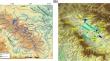
本研究对克什米尔盆地的地表地质和土壤的岩土参数进行了综合分析。利用从岩土工程咨询公司收集的约 700 个地点的标准渗透测试 (SPT) 报告的庞大数据库,绘制了土壤特性的空间分布图。在坚硬、干燥的更新世卡雷瓦土壤中,SPT N 值较高 (~ 10-50),而在饱和的杰赫勒姆河近期冲积层中,SPT N 值较低 (< 20)。这些沉积物显示出较低的塑性指数(17%)以及稳定粘土矿物的存在。卡雷瓦的压缩指数(0.08-0.27)低于冲积层(0.16-0.36),这表明冲积层的沉降危险较高。此外,还绘制了七个横断面和五个纵断面的地质和岩土工程横断面图。作为该研究的一项应用,还提供了大斯利那加城区土壤的承载力估算值和液化敏感性图。结果显示,冲积洪泛平原的极限承载力较低(300 千帕),液化敏感性较高(0.8)。另一方面,Karewas 则显示出良好的承载能力(300 千帕)和中等的液化敏感性(LS 0.5-0.8)。基于这些岩土工程方面的因素,卡雷瓦高地被认为是最适合城市扩张和未来城市化的地方。本研究的结果旨在帮助土木工程师正确设计结构,尤其是地基,并支持城市规划者制定克什米尔城市规划和扩张战略政策。
Geotechnical characterisation and 2D soil cross-section model development in the Kashmir Basin
An integrated analysis of the surface geology with geotechnical parameters of soils within the Kashmir Basin has been presented in this study. Spatial distribution maps of soil properties were prepared using an extensive database of Standard Penetration Test (SPT) reports at ~ 700 sites collected from geotechnical consultancies. The SPT N is high (~ 10–50) in the stiff, dry Pleistocene Karewas and low (< 20) in saturated Recent Alluvial deposits of the Jhelum River. These sedimentary deposits show a low plasticity index (< 17%) as well as the presence of stable clay minerals. The compression index is lower for Karewas (0.08–0.27) than for alluvium (0.16–0.36) indicating higher settlement hazard in the latter. Geological-cum-geotechnical cross-sections along seven transverse and five longitudinal transects were also developed. As an application of this study, the bearing capacity estimates, along with the liquefaction susceptibility map of the soils in the urban area of Greater Srinagar are presented. The alluvial floodplains are revealed to be critical in terms of low ultimate bearing capacity (< 300 kPa) as well as high liquefaction susceptibility (LS > 0.8). On the other hand, Karewas show good bearing capacity (> 300 kPa) and medium liquefaction susceptibility (LS 0.5–0.8). Based on these geotechnical aspects, Karewa highlands were found to be the most suitable for the expansion of the city and its future urbanisation. The results of this study are aimed to assist civil engineers in the proper design of structures, especially foundations, as well as to support urban planners in creating policies for town planning and expansion strategies in Kashmir.
期刊介绍:
The Arabian Journal of Geosciences is the official journal of the Saudi Society for Geosciences and publishes peer-reviewed original and review articles on the entire range of Earth Science themes, focused on, but not limited to, those that have regional significance to the Middle East and the Euro-Mediterranean Zone.
Key topics therefore include; geology, hydrogeology, earth system science, petroleum sciences, geophysics, seismology and crustal structures, tectonics, sedimentology, palaeontology, metamorphic and igneous petrology, natural hazards, environmental sciences and sustainable development, geoarchaeology, geomorphology, paleo-environment studies, oceanography, atmospheric sciences, GIS and remote sensing, geodesy, mineralogy, volcanology, geochemistry and metallogenesis.

 求助内容:
求助内容: 应助结果提醒方式:


