{"title":"利用模拟数据训练卫星测高神经映射方案","authors":"Q. Febvre, J. Le Sommer, C. Ubelmann, R. Fablet","doi":"10.1029/2023MS003959","DOIUrl":null,"url":null,"abstract":"<p>Satellite altimetry combined with data assimilation and optimal interpolation schemes have deeply renewed our ability to monitor sea surface dynamics. Recently, deep learning schemes have emerged as appealing solutions to address space-time interpolation problems. However, the training of state-of-the-art neural schemes on real-world case-studies is hindered by the sparse space-time coverage of the sea surface of real altimetry data set. Here, we introduce an innovative approach that leverages state-of-the-art ocean models to train simulation-based neural schemes for the mapping of sea surface height and demonstrate their performance on real altimetry data sets. We analyze further how the ocean simulation data set used during the training phase impacts this performance. This experimental analysis covers both the resolution from eddy-present configurations to eddy-rich ones, forced simulations versus reanalyzes using data assimilation and tide-free versus tide-resolving simulations. Our benchmarking framework focuses on a Gulf Stream region for a realistic 5-altimeter constellation using NEMO ocean simulations and 4DVarNet mapping schemes. All simulation-based 4DVarNets outperform the operational observation-driven and reanalysis products, namely DUACS and GLORYS. The more realistic the ocean simulation data set used during the training phase, the better the mapping. The best 4DVarNet mapping was trained from an eddy-rich and tide-free simulation data sets. It improves the resolved longitudinal scale from 151 km for DUACS and 241 km for GLORYS to 98 km and reduces the root mean square error by 23% and 61%. These results open research avenues for new synergies between ocean modeling and ocean observation using learning-based approaches.</p>","PeriodicalId":14881,"journal":{"name":"Journal of Advances in Modeling Earth Systems","volume":null,"pages":null},"PeriodicalIF":4.4000,"publicationDate":"2024-07-09","publicationTypes":"Journal Article","fieldsOfStudy":null,"isOpenAccess":false,"openAccessPdf":"https://onlinelibrary.wiley.com/doi/epdf/10.1029/2023MS003959","citationCount":"0","resultStr":"{\"title\":\"Training Neural Mapping Schemes for Satellite Altimetry With Simulation Data\",\"authors\":\"Q. Febvre, J. Le Sommer, C. Ubelmann, R. Fablet\",\"doi\":\"10.1029/2023MS003959\",\"DOIUrl\":null,\"url\":null,\"abstract\":\"<p>Satellite altimetry combined with data assimilation and optimal interpolation schemes have deeply renewed our ability to monitor sea surface dynamics. Recently, deep learning schemes have emerged as appealing solutions to address space-time interpolation problems. However, the training of state-of-the-art neural schemes on real-world case-studies is hindered by the sparse space-time coverage of the sea surface of real altimetry data set. Here, we introduce an innovative approach that leverages state-of-the-art ocean models to train simulation-based neural schemes for the mapping of sea surface height and demonstrate their performance on real altimetry data sets. We analyze further how the ocean simulation data set used during the training phase impacts this performance. This experimental analysis covers both the resolution from eddy-present configurations to eddy-rich ones, forced simulations versus reanalyzes using data assimilation and tide-free versus tide-resolving simulations. Our benchmarking framework focuses on a Gulf Stream region for a realistic 5-altimeter constellation using NEMO ocean simulations and 4DVarNet mapping schemes. All simulation-based 4DVarNets outperform the operational observation-driven and reanalysis products, namely DUACS and GLORYS. The more realistic the ocean simulation data set used during the training phase, the better the mapping. The best 4DVarNet mapping was trained from an eddy-rich and tide-free simulation data sets. It improves the resolved longitudinal scale from 151 km for DUACS and 241 km for GLORYS to 98 km and reduces the root mean square error by 23% and 61%. These results open research avenues for new synergies between ocean modeling and ocean observation using learning-based approaches.</p>\",\"PeriodicalId\":14881,\"journal\":{\"name\":\"Journal of Advances in Modeling Earth Systems\",\"volume\":null,\"pages\":null},\"PeriodicalIF\":4.4000,\"publicationDate\":\"2024-07-09\",\"publicationTypes\":\"Journal Article\",\"fieldsOfStudy\":null,\"isOpenAccess\":false,\"openAccessPdf\":\"https://onlinelibrary.wiley.com/doi/epdf/10.1029/2023MS003959\",\"citationCount\":\"0\",\"resultStr\":null,\"platform\":\"Semanticscholar\",\"paperid\":null,\"PeriodicalName\":\"Journal of Advances in Modeling Earth Systems\",\"FirstCategoryId\":\"89\",\"ListUrlMain\":\"https://onlinelibrary.wiley.com/doi/10.1029/2023MS003959\",\"RegionNum\":2,\"RegionCategory\":\"地球科学\",\"ArticlePicture\":[],\"TitleCN\":null,\"AbstractTextCN\":null,\"PMCID\":null,\"EPubDate\":\"\",\"PubModel\":\"\",\"JCR\":\"Q1\",\"JCRName\":\"METEOROLOGY & ATMOSPHERIC SCIENCES\",\"Score\":null,\"Total\":0}","platform":"Semanticscholar","paperid":null,"PeriodicalName":"Journal of Advances in Modeling Earth Systems","FirstCategoryId":"89","ListUrlMain":"https://onlinelibrary.wiley.com/doi/10.1029/2023MS003959","RegionNum":2,"RegionCategory":"地球科学","ArticlePicture":[],"TitleCN":null,"AbstractTextCN":null,"PMCID":null,"EPubDate":"","PubModel":"","JCR":"Q1","JCRName":"METEOROLOGY & ATMOSPHERIC SCIENCES","Score":null,"Total":0}
Training Neural Mapping Schemes for Satellite Altimetry With Simulation Data
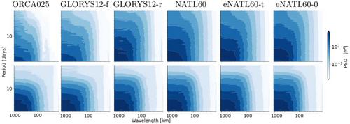
Satellite altimetry combined with data assimilation and optimal interpolation schemes have deeply renewed our ability to monitor sea surface dynamics. Recently, deep learning schemes have emerged as appealing solutions to address space-time interpolation problems. However, the training of state-of-the-art neural schemes on real-world case-studies is hindered by the sparse space-time coverage of the sea surface of real altimetry data set. Here, we introduce an innovative approach that leverages state-of-the-art ocean models to train simulation-based neural schemes for the mapping of sea surface height and demonstrate their performance on real altimetry data sets. We analyze further how the ocean simulation data set used during the training phase impacts this performance. This experimental analysis covers both the resolution from eddy-present configurations to eddy-rich ones, forced simulations versus reanalyzes using data assimilation and tide-free versus tide-resolving simulations. Our benchmarking framework focuses on a Gulf Stream region for a realistic 5-altimeter constellation using NEMO ocean simulations and 4DVarNet mapping schemes. All simulation-based 4DVarNets outperform the operational observation-driven and reanalysis products, namely DUACS and GLORYS. The more realistic the ocean simulation data set used during the training phase, the better the mapping. The best 4DVarNet mapping was trained from an eddy-rich and tide-free simulation data sets. It improves the resolved longitudinal scale from 151 km for DUACS and 241 km for GLORYS to 98 km and reduces the root mean square error by 23% and 61%. These results open research avenues for new synergies between ocean modeling and ocean observation using learning-based approaches.
期刊介绍:
The Journal of Advances in Modeling Earth Systems (JAMES) is committed to advancing the science of Earth systems modeling by offering high-quality scientific research through online availability and open access licensing. JAMES invites authors and readers from the international Earth systems modeling community.
Open access. Articles are available free of charge for everyone with Internet access to view and download.
Formal peer review.
Supplemental material, such as code samples, images, and visualizations, is published at no additional charge.
No additional charge for color figures.
Modest page charges to cover production costs.
Articles published in high-quality full text PDF, HTML, and XML.
Internal and external reference linking, DOI registration, and forward linking via CrossRef.
 求助内容:
求助内容: 应助结果提醒方式:


